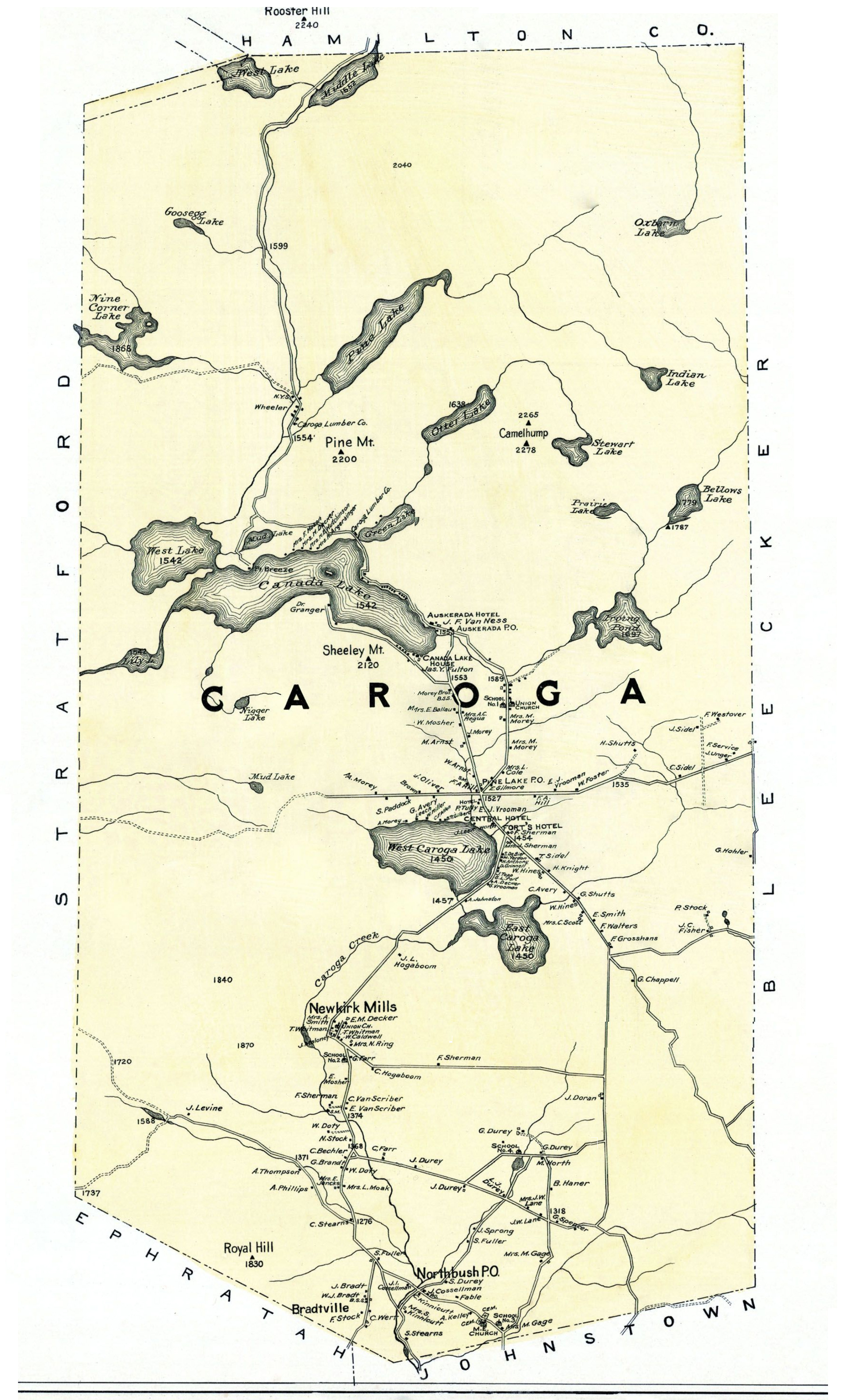
Maps from the past document how the Lake has changed and the community has developed over the years. This page explores a series of maps going back to the middle of the nineteenth century. To flesh out details of the maps, we will depend on Barbara McMartin’s Caroga: an Adirondack Town Recalls Its Past. Names emerge on the maps that appear in the index of McMartin’s book and the family records of Lake residents. Readers are encouraged to correct and supplement this account.
Detail of the 1856 Map of Fulton County:
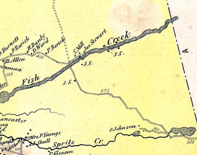
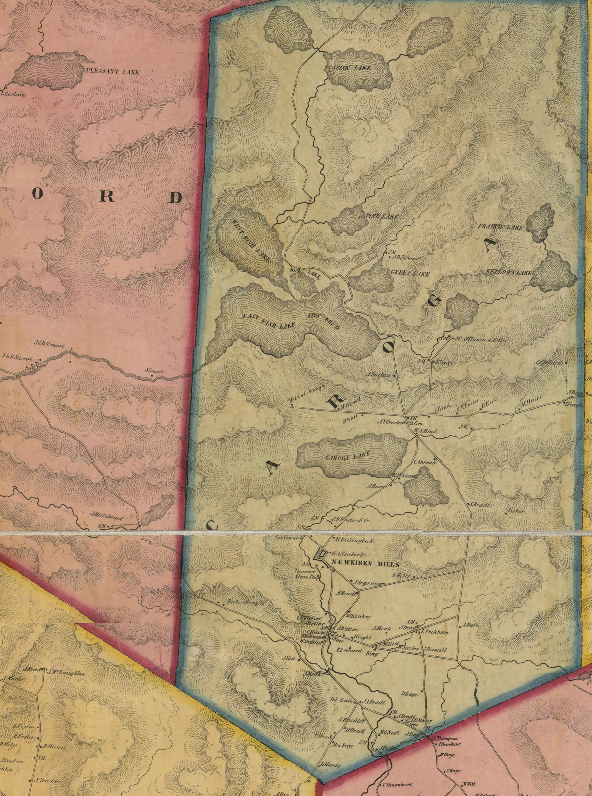 The 1856 map of Fulton County gives us an early picture of the development of the Town of Caroga. Whereas today the Town of Caroga revolves around its lakes, the town’s streams were the focus of the town’s industries at this early period. The streams powered the saw and grist mills. The initials “SM” that dot the 1856 map document the number of saw mills in the Town of Caroga.
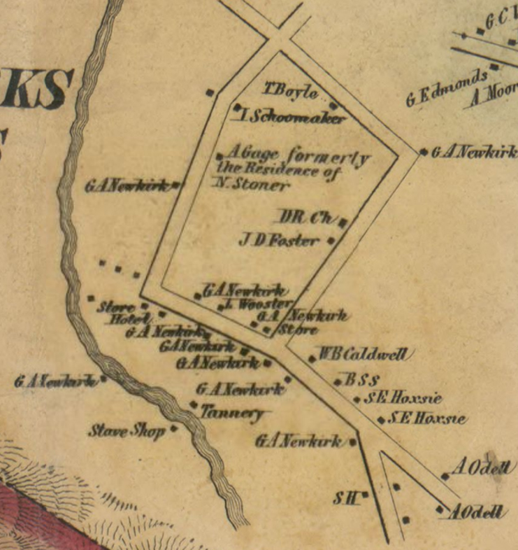
Most significantly was the hamlet of Newkirk Mills, the largest town in Caroga in 1856. Founded by Garrett A. Newkirk, the settlement built along the Caroga Creek had grown to over twenty buildings. Newkirk had built a small dam to power a saw mill there in 1840, and in 1843 with the collaboration of John Littlejohn, Newkirk constructed a tannery, which closed in 1857. As recorded on the map, Newkirk Mills was the last residence of Nick Stoner. The map records other saw mills along the Caroga Creek, inlet to Canada Lake, and the stream entering Green Lake from Otter Lake. Saw mills owned by James and Daniel Stewart appear on the channel leading out of Canada Lake and on the site of the current Stewart’s Landing Dam.
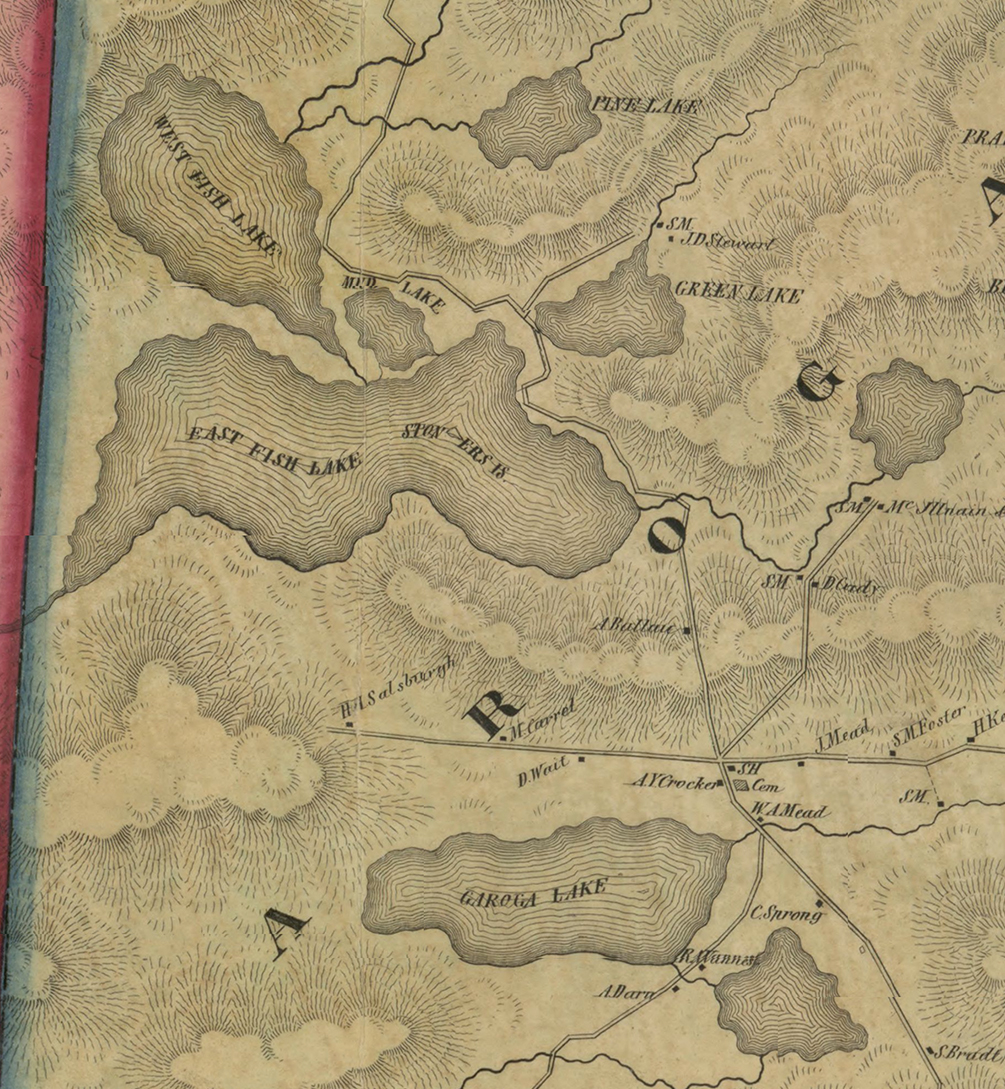 Striking is the absence of any recorded development around the lakes. While the island on Canada Lake has already been named “Stoners Is,” Canada and West Lakes are recorded as East and West Fish Lakes respectively. Caroga is recorded as “Garoga.” Wheelerville does not exist. The omission of Otter and Nine Corner Lakes from the map indicates how little was known of the area at this time.
A road is recorded as leading up from the south through Caroga and Canada Lakes up through what we now know as the Stoner Lakes but here listed as “Stink Lake” and on further north. In 1841, the State Legislature authorized the construction of a road from Newkirk Mills to Piseco (McMartin, p.30). There was also the Caroga and Fonda Plank road which opened in 1849, and was designed to carry lumber and hides from the mills to the rail line in Fonda (McMartin, p. 23).
It is interesting to compare the visual record of 1856 to a nearly contemporary verbal description of the area presented in Jephta Root Simms, Trappers of New York (Albany, 1851):
The southerly portion of country under consideration is hilly and in many places mountainous. The soil is generally stony, though in many instances fertile; but far better adapted to grazing, than the production of grain. The prevailing rock is of the primitive order, consequently the shores of the lakes which sparkle here and there in glens, abound in deposites of beautiful sand. The timber is principally beech, birch, maple, hemlock, and spruce. Much of the hemlock is sawed into fence-boards, and acres of spruce annually wrought into shingles or sawed into floorplank; all of which find a ready market at the nearest accessible point on the Erie Canal; and since Garoga and Fonda plank road is favorable to its removal, not a little will find its way to Fultonville, where considerable quantities were landed before the plank road was laid out.
Much of this country still has a primeval look, but its majestic forest lords and advantageous water powers, must in time invite the thrifty artisan and hardfisted yeoman, to subdue and cultivate it….
Simms views the land from the perspective of the settler eyeing the economic potential of the area which offers the “thrifty artisan and hardfisted yeoman” the challenge to “to subdue and cultivate.” While the rocky soil presents challenges for the farmer, the ample supply of timber, “advantageous water powers,” and “Garoga and Fonda plank road” provide a lot of potential for the lumberman.
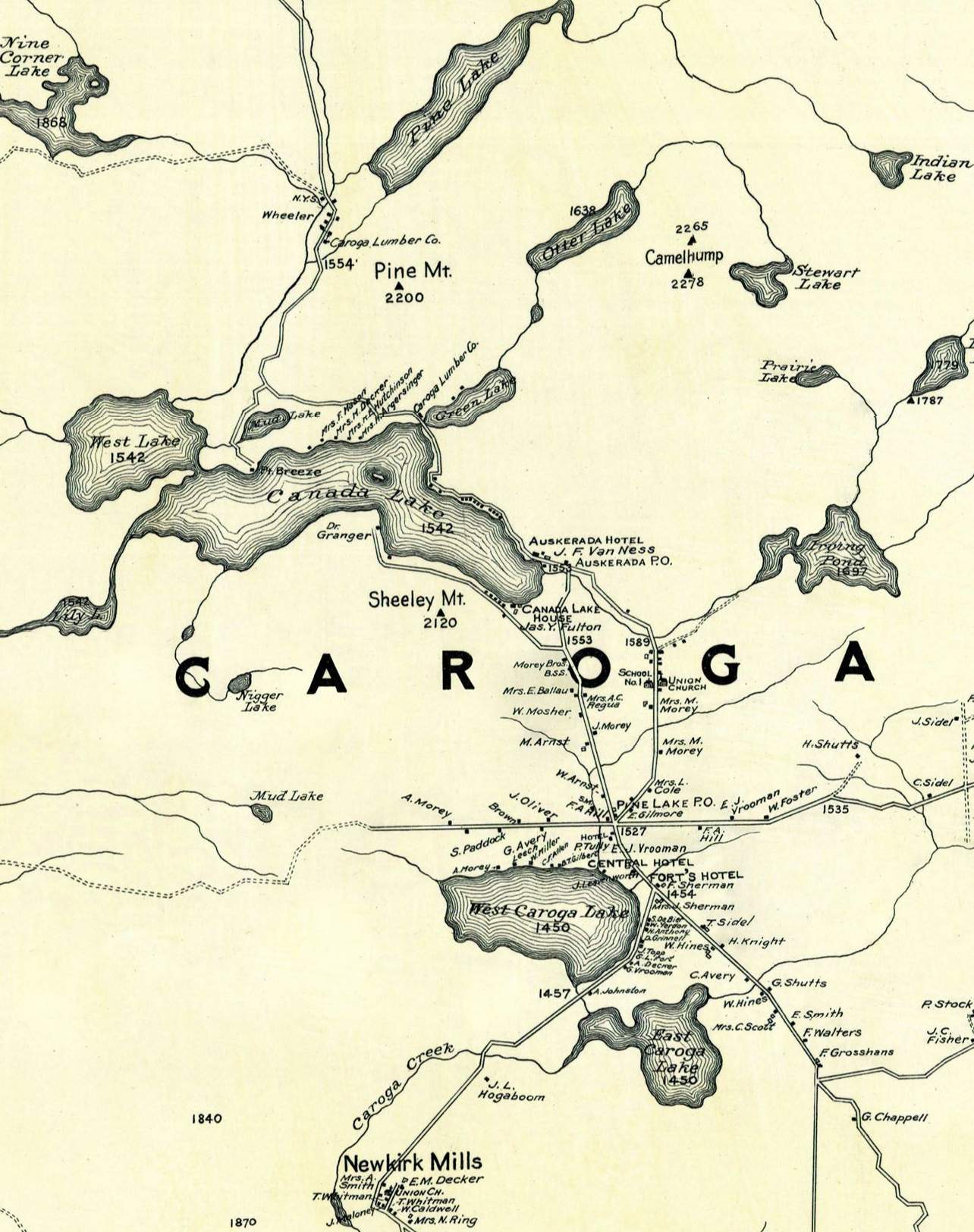
1868 Map of the Town of Caroga:
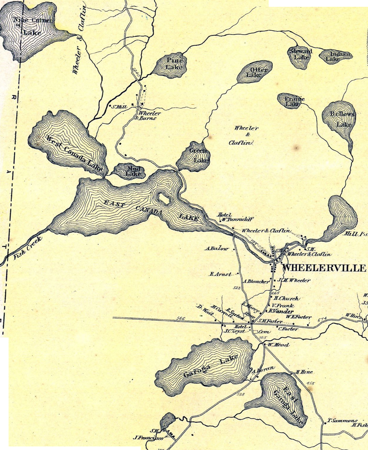
Between the 1856 and 1868 maps, the Town of Caroga had undergone a dramatic change. The map of 1868 is dominated by the names Wheeler & Claflin. In 1865 William Claflin had need of leather to supply his shoe factories in the Boston area. He established a partnership with Jonathan Wheeler. The Wheeler Claflin Company acquired 20,000 acres in the Town of Caroga alone, two-thirds of the town’s land. The large stands of hemlocks were crucial for their tannic acid to cure the leather.
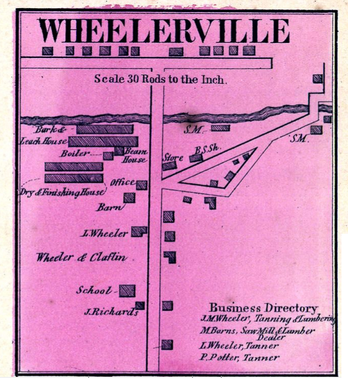
They built huge barns to house the tannery in what became known as Wheelerville. The 1868 map shows Wheelerville as a thriving community [for the Wheeler Claflin Company see McMartin, pp. 32-44]. The depletion of the hemlock forests led to the closing of the tannery by the mid 1880s.
The 1868 map identifies what we know as Irving Pond as Mill Pond. In 1855, James Irving moved to the area and ran a sawmill. 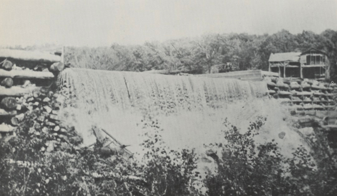 He built the first dam, a wooden structure, to help power the mill. He also used the land now the golf course as pasture land. Subsequent maps of the area will label the pond as Irving Pond. The sawmill would be torn down between 1910 and 1912 [McMartin, pp. 111-114].
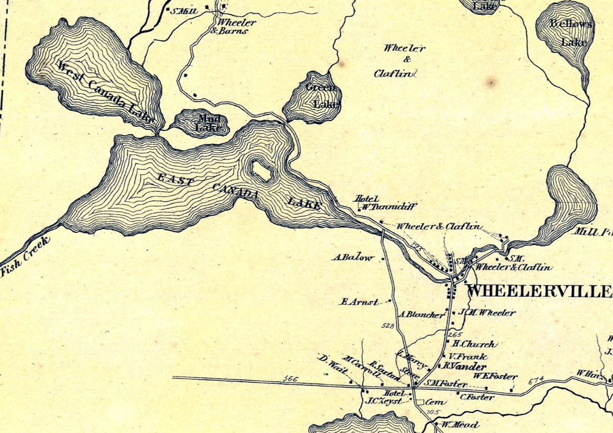 The only building identified on the Lake is the Hotel of W. Tunnicliff. The Canada Lake House was built in 1866 on the site that would later become the Auskerada Hotel. It was managed by W.R. Tunnicliff. This hotel was an early example of the Adirondack resort hotels that became popular beginning in the 1850s [McMartin, pp. 44-46]. In 1884, the Canada Lake House was destroyed by fire. The land was left vacant until the Auskerada was built on the site in 1894.
The 1868 map already identifies family names that will appear regularly in town and family records over the generations: Arnst, Balow, Foster, and Morey. Eune Arnst, who had emigrated from Switzerland, was a shoe maker and farmer and owned a house on London Bridge Road [McMartin, pp. 47-49]. The Arnst property is now the location of the Caroga Historical Museum. His grandson, Alvarado, characterized as the local strongman, appears in the Streeter family records building a light weight rowboat for the Streeter children in 1925. In 1930, Alvarado cut and split 5 cords of wood for the Streeters. The Balow listed is probably the Ballou family. Elizabeth Ballou had purchased in 1859 a 77 acre farm on London Bridge Road [McMartin, p. 30]. In the 1890s, Lewis Ballou was a storied captain of one of the steamers [McMartin, pp. 78-80]. The Foster family had been residents in the area since at least the 1840s [McMartin, p. 30]. A descendant, Burtell Foster was involved with the construction of a number of camps in the building boom of the 1920s. Alanson Morey moved into the area in 1847, and was a blacksmith and farmer. The index of the Caroga book lists a large number of members of the Morey family.
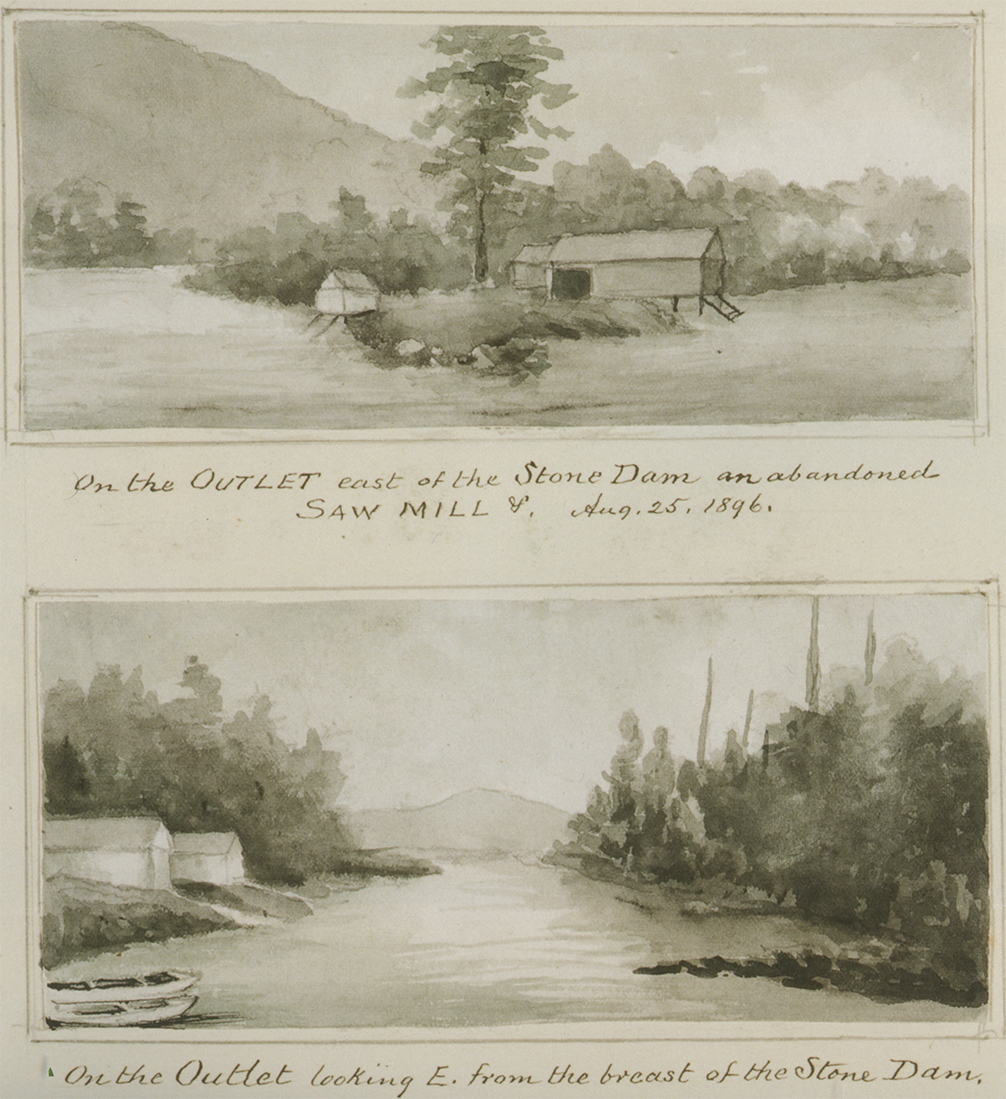
 A detail of the 1868 Stratford map shows the sawmill run by James Stewart on the site of the future Stewart’s Landing Dam. Then the outlet of the Lake was known as Fish Creek. The map also records land owned by James Stewart upstream where an early stone dam was constructed near another sawmill. Rufus Grider in his Canada Lake album includes two sketches from 1896 of the abandoned sawmill east of the stone dam.
Simmons & Van Ness Allotments:
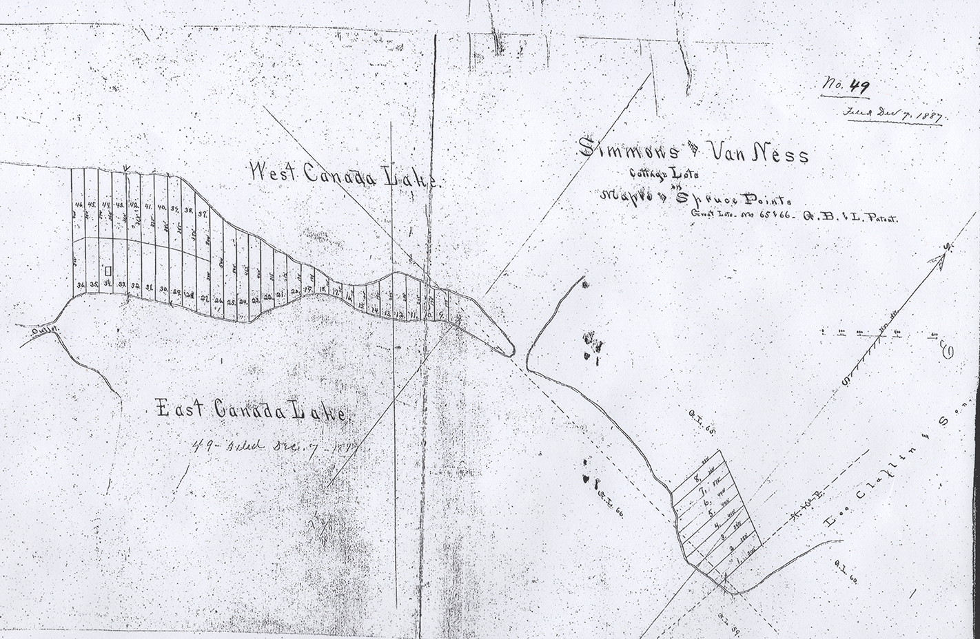
A map dated Dec. 7, 1887 records lots on what was known as Maple & Spruce Points, what are today Dolgeville Point and Point Breeze. A 1904 article recording the foreclosure sale of the Alfred Dolge properties documents that on August 23, 1887, Milton Barnes, who was a partner of Wheeler and Claflin, had conveyed to Joseph Fitch Van Ness and others the properties on Maple and Spruce Points [Book 69 of Deeds at page 268]. Joseph Fitch Van Ness and his partner Albert N. Simmons were two prominent Gloversville businessmen. Van Ness would subsequently become the proprietor of the Auskerada Hotel.
The 1904 article goes on to enumerate a number of the lots sold: on May 2, 1889, Raymond Hillabrandt acquired lot 1 which would become the Point Breeze Club [Book 71, page 284]; E.H. Drumm on December 1, 1892 purchased lot 21 [Book 81, page 578]; Henry and Frank Faville in a deed dated March 26, 1890 bought lots 9-13 [Book 87, page 57]; the Favilles subsequently purchased lot 14 on April 18, 1890. In a deed dated March 12, 1894, Simmons and Van Ness convey the remaining lots to Alfred Dolge [Book 90, page 69].
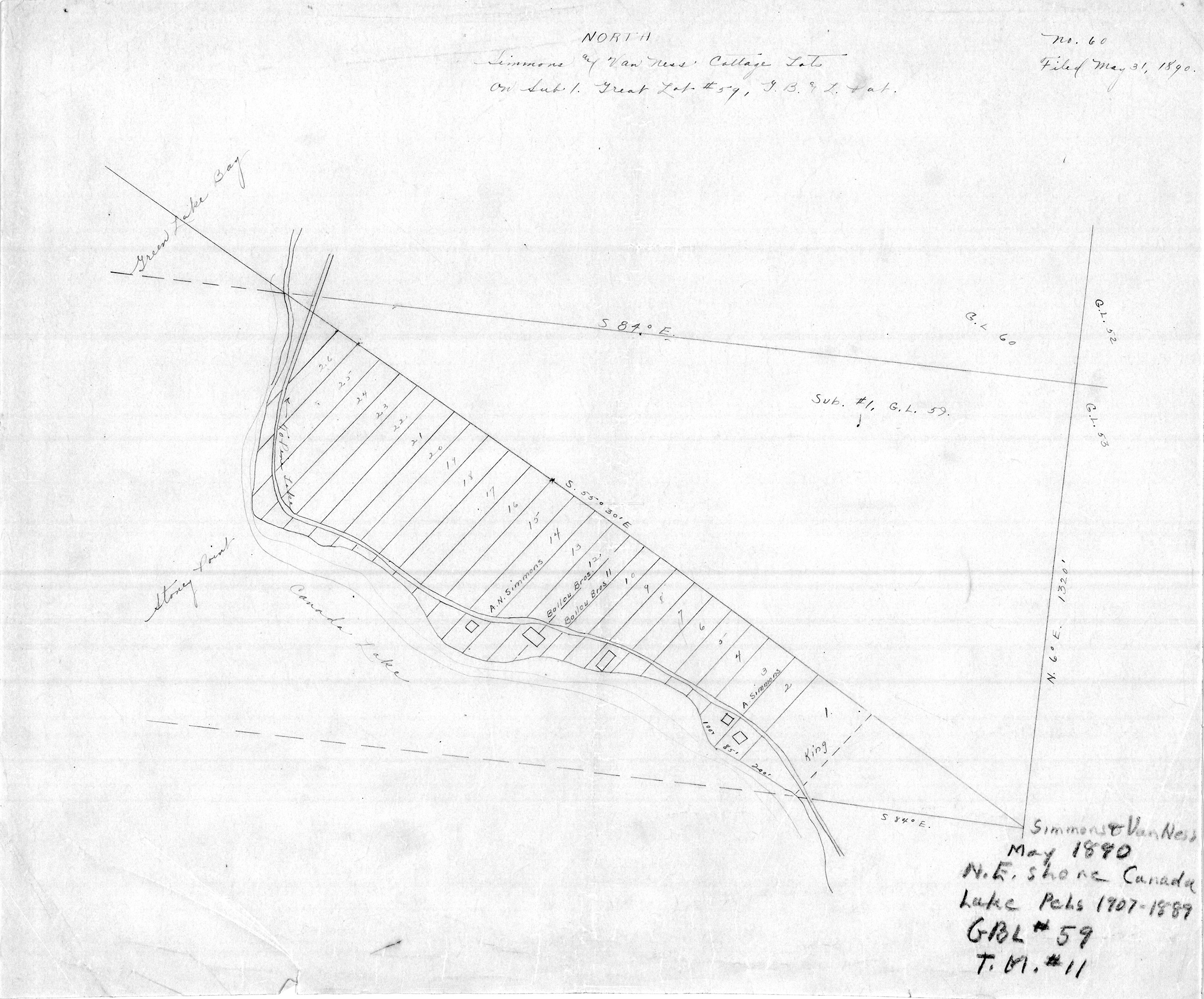
Simmons and Van Ness acquired a second allotment consisting of a string of lots from Stony Point east to what is now 307 Kasson Drive. A map dated May 31, 1890 documents this allotment:
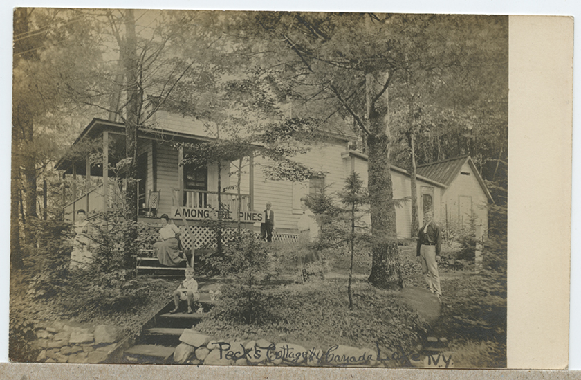
“Peck’s Cottage, Canada Lake, N.Y.,” real photo postcard, ca. 1910.
Andrew Peck would buy up the Stony Point parcels. A real photo postcard shows one of these Peck cottages here named “Among the Pines,” but now known as “Scott Lodge” and owned by the Sasscer family.
Lee Claflin & Son Allotment:
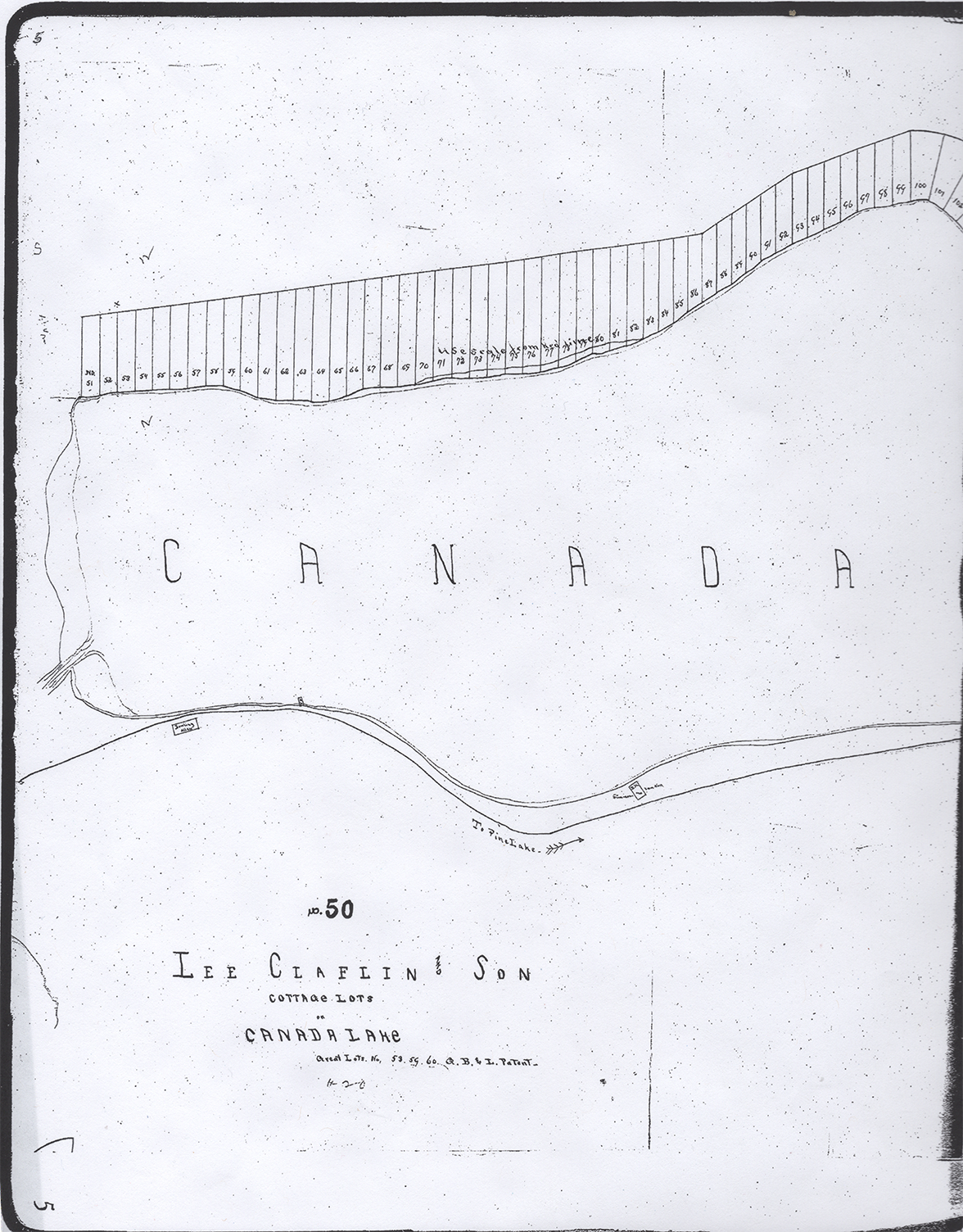
In a letter dated March 5, 1887. Lee Claflin writes to his attorney J. M. Dudley: “It is our intention to have the lake shore surveyed and developed into cottage lots, in such a way that it will be an agreeable place for summer residents and tourists [McMartin, p. 50].” The map above of Lee Claflin cottage lots is undated, but it is likely from 1890 or after. This is based on the inclusion of a reference to Simmons and Van Ness around a structure labelled “BK” on the north shore at the bottom of the map. The map of the Simmons and Van Ness allotment is dated May 31, 1890 and John King acquired Lot 1 in June of 1890. Is “BK” a transcription error for “JK” ?
In a deed dated June 17, 1892, William Claflin and his wife conveyed to Alfred Dolge the Clalfin lands. In a deed dated May 1, 1896, Dolge transferred ownership to his Caroga Land Company [ Book 101 at page 45].
The numbering of the lots along the south shore was continued by Cyrus Durey and the Durey Land and Lumber Company as will be seen later on the tracing of the 1906 map of the Auskerada Park.
The 1897 Auskerada Park Club Map:
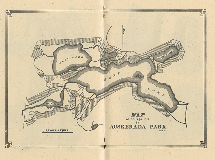 In 1895, Alfred Dolge, a German immigrant, who had built a town, factories, and sawmills and planned railroads and power dams, engaged in a new venture acquiring with a group of investors 4,500 acres in the area around the Canada Lakes with “the purpose of promoting an association to utilize and develop its advantages as a summer resort.” In 1897, they published a lavish pamphlet to advertise what they named the Auskerada Park Club. Included in this pamphlet is a map showing the division of the land into different “cottage lots.” The club would also profit from the sale of timber. The brochure makes clear that the membership will be open to “none but a class of gentlemen whose reputations are beyond question; business and professional men of influence and standing. The success of the Club is assured by the character of the organizers, and the gentlemen whose names have been proposed for membership.”
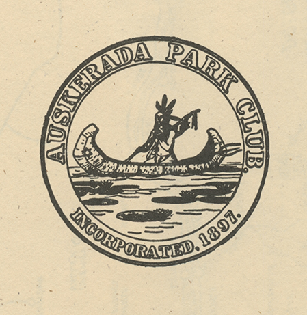 The pamphlet is entitled Aughstagradi, a Tale of the Auskeradas. It begins with the romantic story of Aughstagradi, a young chief of the Hurons, and his outdoing Ongowanda, a chief of the Mohawks. Ongowanda prided himself as a great fisherman. He vowed that we would give his cherished canoe as a token to whoever could outdo him. The most cunning fishers from many tribes had come here to attempt to rival the skill of the Mohawk chief, but all had gone back disappointed. Aughstagradi whose name means “the-chief-who-catches-many-fishes” surpassed Ongowanda. The older chief greets Aughstagradi on the Island, and “with a magnamity that speaks of the depth of his soul, he presents to Aughstagradi the lakes and lands surrounding them” along with his prized canoe as a token of his victory. The seal of the Auskerada Park Club shows Aughstagradi holding a string of fish in Ongowanda’s canoe.
It is notable that the pamphlet gives a Native American origin myth for the lakes. The pamphlet juxtaposes the romantic idea of the “noble savage” of Ongowanda and Aughstagradi to the prospective members of the club who are “business and professional men of influence and standing.” Dolge attempted to rename the lakes the Auskeradas. In the pamphlet, there is no mention of the Nick Stoner legends of the heroic frontiersman.
An alternative version is presented by Rufus Grider in his Canada Lake Album of 1896. He writes: The Mohawk Indians we now know, had a Village at or near this Lake, they named it: KAN-AUGH-TA-AUS-KE-RADA. Not the Lake, but that Village was so called. In the Mohawk language its meaning is —“Village on a Bank or on a Hill.” Kana-augh-ta-Kanata-or Canada means Village, “Auskerada” does not mean “many fishes” as is believed by the people & visitors at the Lake. One of the early steamers on the Lake would be named the “Kanaughta.”
There is no mention in Grider’s account of Aughstagradi, but he does give attention to Nick Stoner. In a section entitled “Stoner’s Island,” Grider gives a brief biography of Stoner’s role as a soldier in the Revolutionary War and the War of 1812 before recounting his activities as a hunter and trapper. Grider talks about how the Island was used as a headquarters for the hunters. A hut on the Island was used for the drying and stretching of skins. Grider sees the significance of Nick Stoner as “the forerunner of Civilization” preparing “the way for the “First Settler” making family life possible in the wilderness, when that is yet in a state of nature.” It would be the story of Nick Stoner and not Aughstagradi that would dominate the local lore of later generations.
Dolge and his partners’ venture with the Auskerada Park Club failed with Dolge declaring bankruptcy in 1898. The unrealistic nature of this venture is apparent when one examines the map and sees that lots have been mapped out over the swampy terrain of areas like much of West Lake.
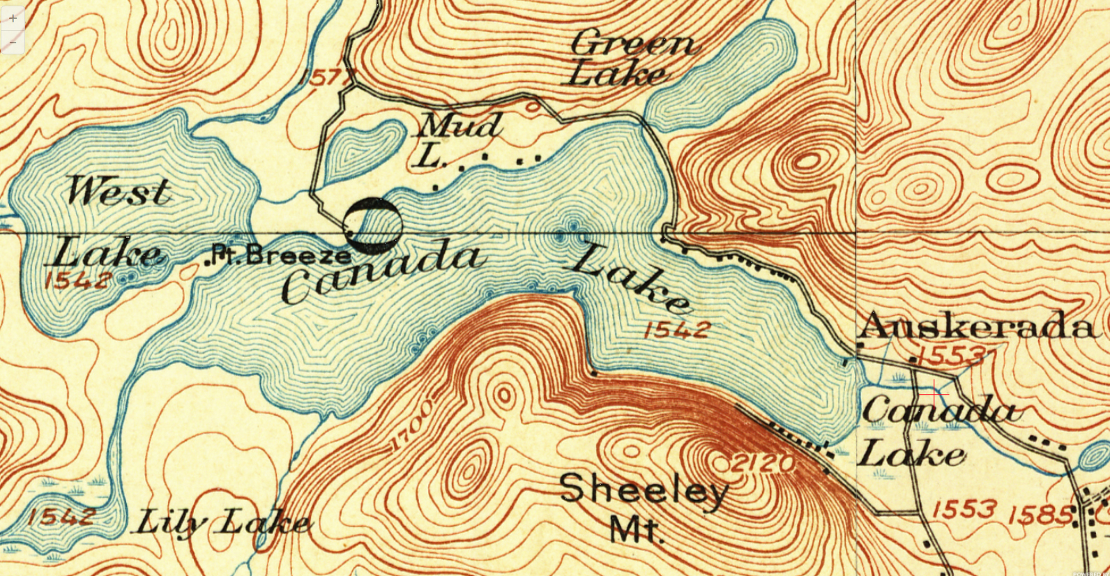
The 1901 USGS Map:
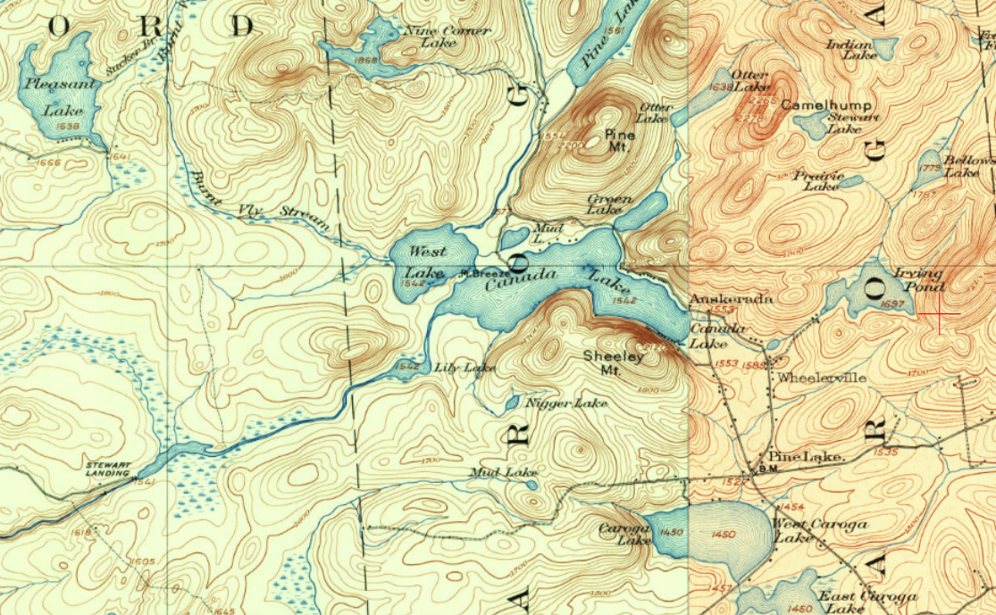
The 1901 map includes the Stewart’s Landing Dam which had been built in the late 1890s [McMartin, pp. 76-77]. Click here for a composite of 1901-1903 USGS maps of the region. Rufus Grider in his Canada Lake Album presents the following description of the outlet in 1896:
The outlet and Lakes connecting are deepened by a stone dam, from there the water descends 4 1/2 feet into Stewart’s Dam, forming another waterpower. There another abandoned village, vacant dwellings and silent Saw Mill exists….
The remains of this earlier stone dam which powered a saw mill are still visible downstream from Lily Lake.
The Stewart’s Landing Dam made the channel more navigable for the steamers that were becoming popular for summer visitors. The 1903 map shows that the road from Stratford ended at Pleasant Lake with only a trail continuing to Pine Lake. So making the channel more navigable helped open the Lake for travelers from the west from towns like Dolgeville.
But this dam did not solve the issues. As shown on the map, the channel leading down to the dam was still very narrow. Where today in many spots there is open water then there were weed beds. In addition, each summer the water level would be drawn down to power the dam. James Y. Fulton, the owner of the Canada Lake House and who was involved in the steamer business, complained that the lakes became “unnaturally low in the summer season, to the injury and annoyance” of summer residents.
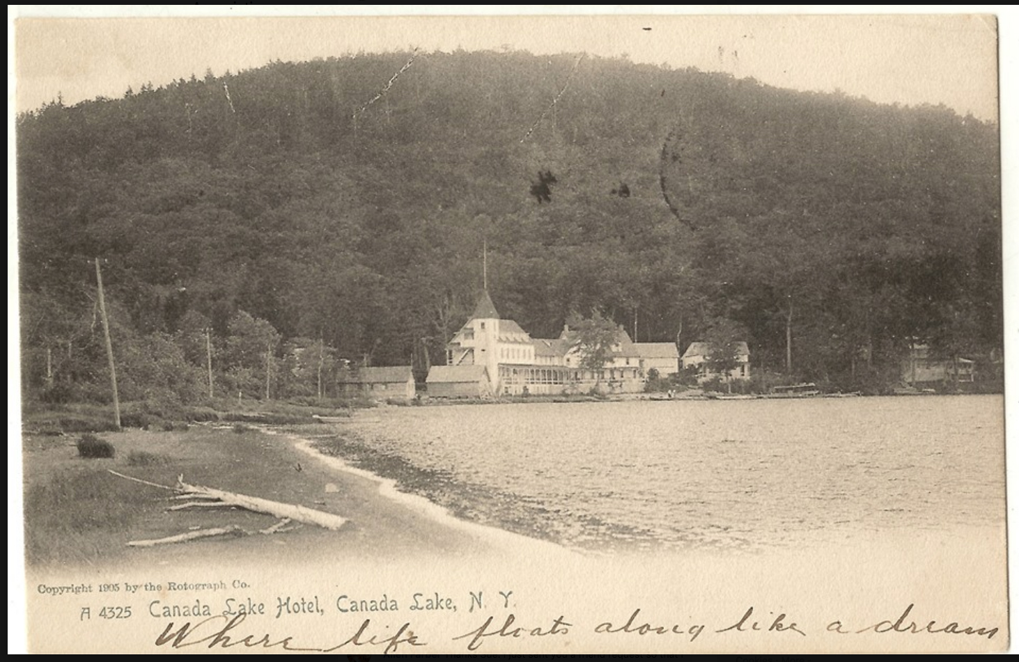
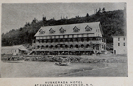
A postcard from 1905 of Fulton’s Canada Lake Hotel supports this complaint. A view of the Auskerada taken about the same time is even more dramatic. There is a beach where today we would expect to see the channel leading under London Bridge.
As documented by the map, the accepted level of the Lake in 1903 was 1542′, over a foot below today’s summer level of 1543.1′. The solution was the creation of a new dam in 1912 and 1913 [McMartin, p. 77].
The 1903 map witnesses the beginnings of a lake community. There were two grand hotels on the Lake: the Auskerada built on the site of the Canada Lake house and a second Canada Lake House that was owned by James Y. Fulton. The prominent appearance of the name “Auskerada” identifies the location of the local Post Office. In 1906, the name was changed to “Canada Lake”, and the office was moved over to Fulton’s Canada Lake House. In 1913, the post office name was changed again, this time to Green Lake [McMartin, p. 74]. What was known as the Pine Lake Post Office was located at what is known as the Five Corners in Caroga [McMartin, p. 32].
The 1903 map documents the construction of camps in the Simmons and Van Ness allotment on Kasson Drive. This map shows no maps as having been constructed to the east of the Simmons and Van Ness properties down to the Auskerada.
Five camps are marked along the north shore. A road leads off of the State Highway to the Point Breeze Club. Godfrey Hillebrandt built a cottage in the 1890s on the point adjacent to the channel leading to West Lake. Hillebrandt along with his friends formed a men’s club. The descendants and relatives of these original members are still residents of the Lake [McMartin, pp. 103-105].
On the south shore, Fulton Road leads off of London Bridge Road to the Canada Lake Hotel and a number of camps around it. In 1903, no South Shore Road is marked, and there is a single camp identified, the summer residence built in the 1890s for the minister of the Johnstown Presbyterian Church.
In 1903 the highway would have continued north through Pine Lake like Rt. 10 does today to Piseco. Today’s Rt. 29A leading out of Pine Lake was an unimproved road.
c. 1905 Sheeley Mountain Panorama:
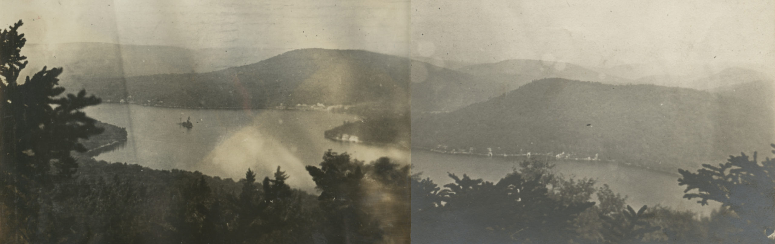
The image above combines two photographs creating a panorama from the top of Sheeley Mountain. The photos were from a descendent of the Mason family who owned a camp known as  “Seven Oaks” on Decker Road. The panorama clearly documents the development of the lake at this period. A good number of the Simmons and Van Ness lots have been developed along what is now Kasson Drive. The three camps on Stony Point have been built. Camps are visible along Decker Road and the lumber company is clearly visible. There are no camps visible on the South Shore. The Presbyterian Church camp is out of sight. The sawmill of the Caroga Land and Lumber Company was constructed during the spring of 1905. This helps to date the photographs to 1905 or later.
1905 Map of the Town of Caroga
The 1905, property map prominently displays the two hotels and their owners with J.F. Van Ness as the owner of the Auskerada and James Y. Fulton for the Canada Lake House.
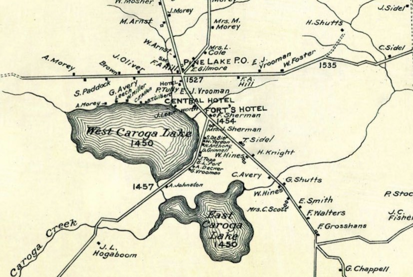
Many of the families that appeared on the 1868 map reappear on this map: Arnst, Ballau, Foster, Morey, among others. New names like Groshans, Sherman, and Vrooman who become important to the history of the Town of Caroga appear on this map.
 A number of property owners are identified on the Lake. Dr. Granger built a camp on the south shore near Sand Point this along with the Presbyterian Church were still the only camps on the south shore beyond those around the Canada Lake House. On the north shore, Mrs F. Mason, Mrs. M. Decker, Mrs. R.E. Hutchinson, and Mrs. Argersinger are identified as owning camps. Eberly Hutchinson had built two camps, one for himself and his mother and the second for his mother’s sister Mrs. Argersinger. These are the last two camps today on Hutchinson Rd.
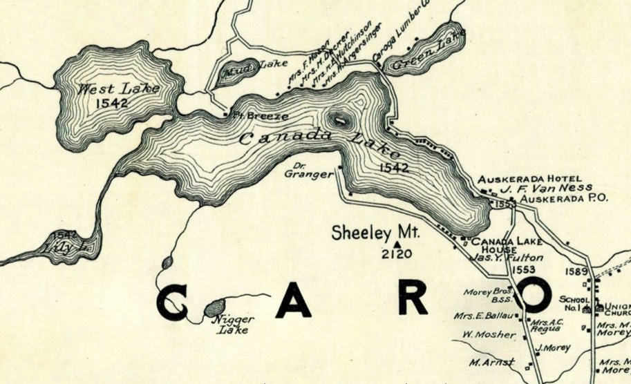
Of particular significance is the identification of the Caroga Lumber Company between Canada and Green Lakes. In 1904, the Caroga Land and Lumber Company had acquired in a bankruptcy sale the lands previously owned by Alfred Dolge. Cyrus Durey, a local businessman and politician, was instrumental in this sale. We know that year Frank Sherman was managing the mill on the Canada Lake site, but by 1908, he had built a dam on Pine Lake and a mill there. Cy Durey maintained control of the Canada Lake interest. He would say: “When my company erected its mill at Green Lake in 1904, there was a recurrence of industrial life and since the timber available for use of that mill has been cut, the life of the Town lies in its summer business, which business has marvelously increased since the construction of the improved roads into the town.”
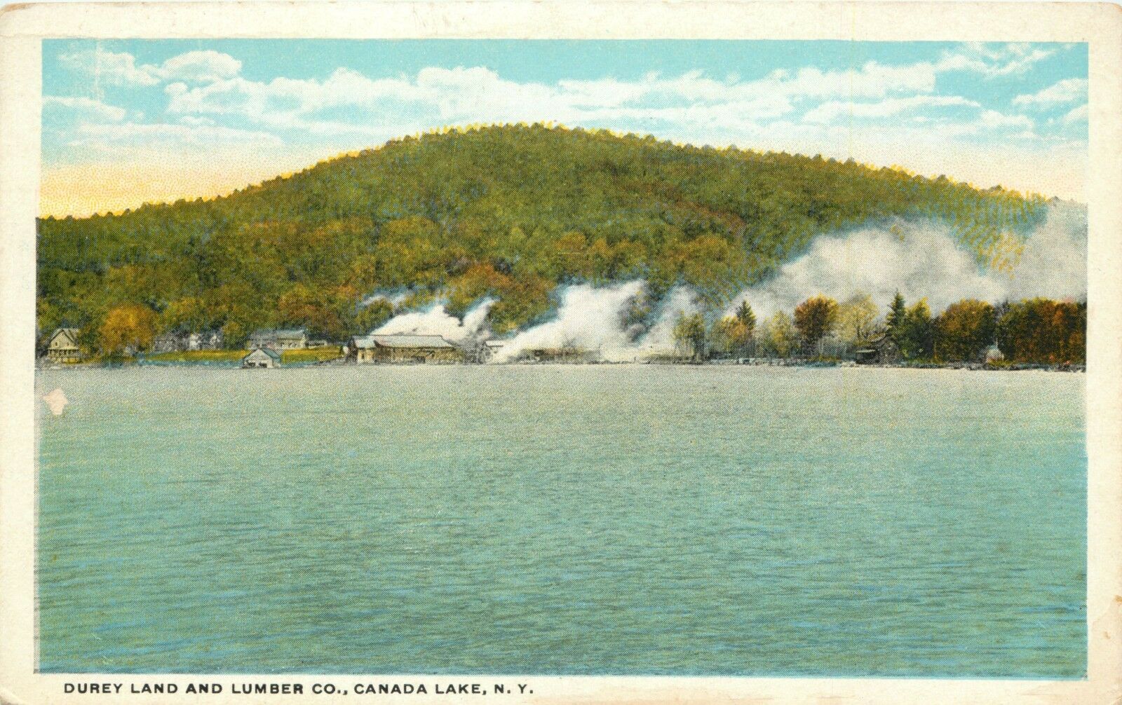
On July 3, 1912, the Caroga Land and Lumber Company was replaced by the Durey Land and Lumber Company. While the sawmill on Canada Lake continued in operation until it burnt in 1926, much of the focus of the business was on the sale of lots for summer residents. Deeds of lake properties regularly document the acquisition of the land from Durey Land and Lumber Company. Cy Durey was instrumental in the development of the area with the building of the new dam in 1912 and 1913 and the creation and improvements of the roads around the lake.
During the summer of 1908, Paul Bransom was renting Dr. Granger’s camp, which was next door to the Dwigwam, built by Clare Victor Dwiggins in 1907 [McMartin, p. 173]. In his memoir All Unplanned, Paul Bransom presents the following account of a conversation that summer with Dwig and Cy Durey:
As I think of that summer back in 1908 when we first saw Canada Lake, I remember one afternoon Dwig and Cy Durey and I were sitting on a patch of lawn near Cy’s house. We were close to a huge pile of logs near the lumber mill, then operating full blast. These logs were ready to be sawed and we sat there munching grass stalks and talking about everything and nothing in particular. Cy turned to me and said, “You ought to have some land up here.”
I replied, “Yes, I would like to.” It had never occurred to me.
Cy continued, “Beyond the Mills Point, west, over there” (he pointed), “there’s a bay where I think there are ten lots in all. You can have them, all the lots in the bay, for a hundred dollars a lot.”
Of course, a thousand dollars was then more money than I had at my disposal and I always had a horror of being in debt. This caution has been a weakness of mine and has cost me dearly. I’ve had many opportunities to get into things entailing the payment of a little money down and a lot later, which I have avoided. I wish I had been more venturesome and had a more “take a chance” attitude because I could have been a millionaire on each of two or three different occasions. I know that now, the way things have turned out. I always made the same mistake. However, I have been well rewarded for my work and have no real regrets that I missed these opportunities to become more wealthy. I am rich in experience and memories!
Well, I didn’t buy Cy Durey’s land at a hundred dollars a lot and I returned nine years later and paid twice as much apiece for two lots! However, our friends, the Sarkas, were more farsighted. They bought five lots of what is now very high-priced land [All Unplanned, p. 99].
Copy of 1906 Map of the Auskerada Park:
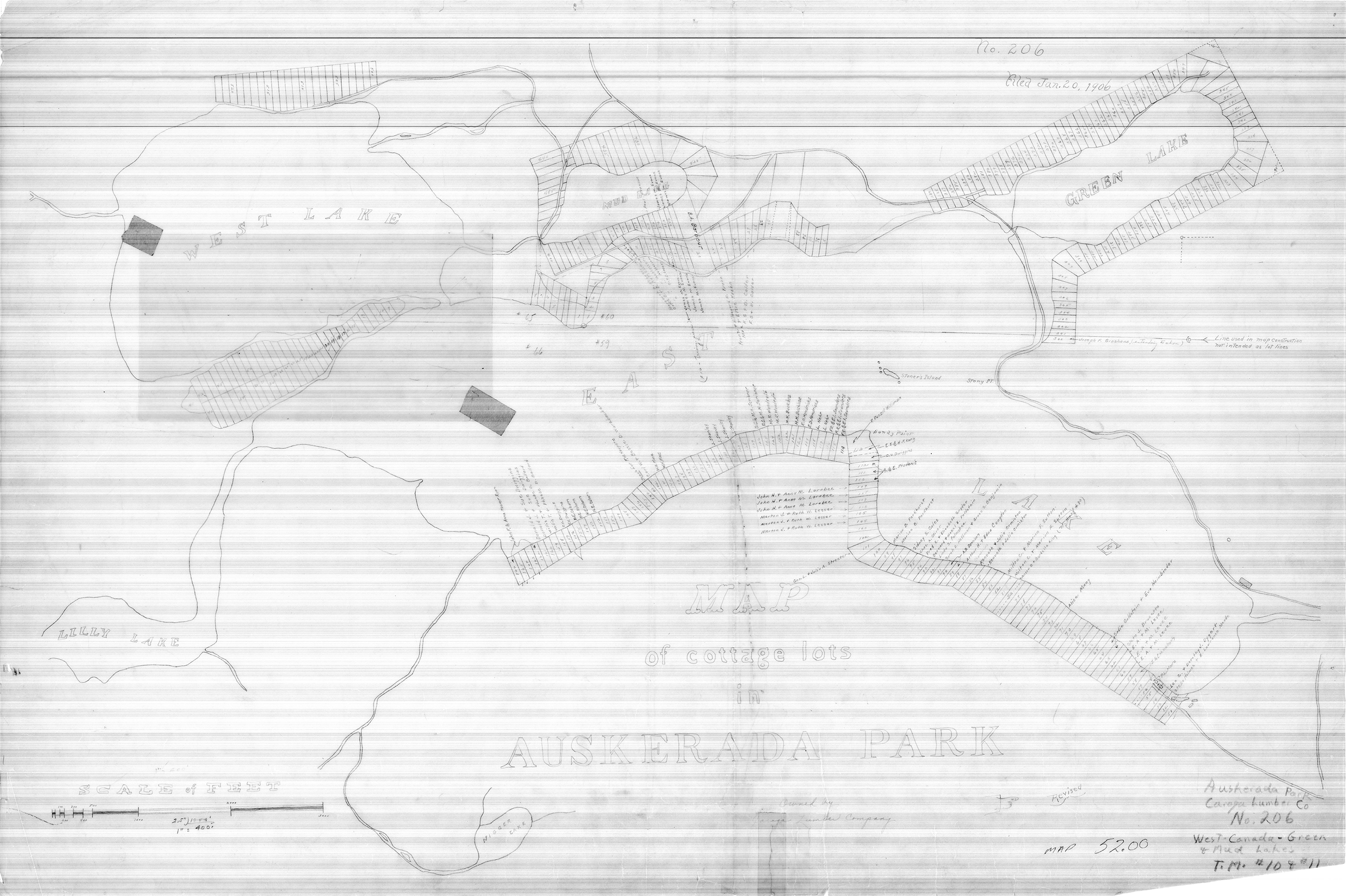
This map is a tracing from a map dated January 20, 1906. The tracing likely was done between 1943 and 1948. Included on the map are the property owners from this later period. This map was probably used in creating the 1945 survey of the south shore.
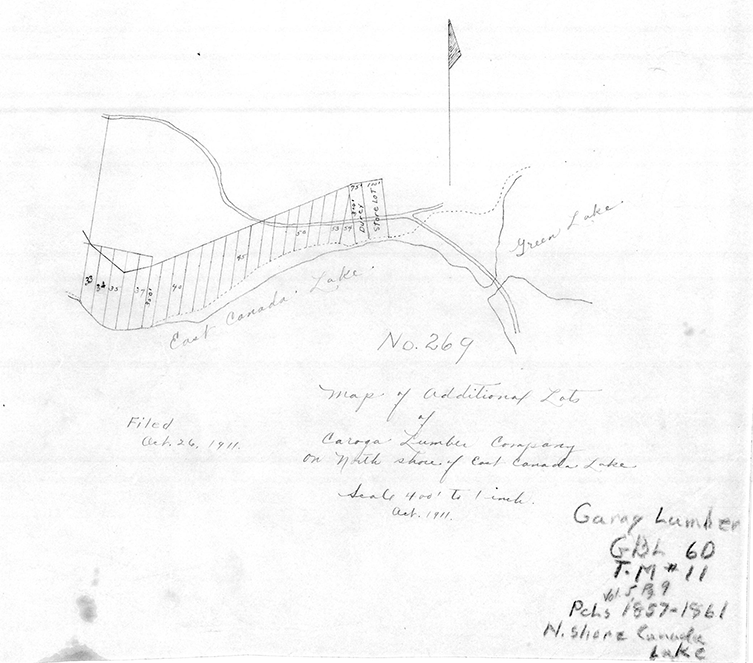
The original 1906 map gives the lot numbers of the Lee Claflin & Son that were used by Durey Land and Lumber Company. These numbers continue to be referenced in deeds to this day. The sequence begins at the first camp to the east of Point Breeze and follows along the north shore until lot 37 at what is now 135 Hutchinson Rd. Lots 38-47 (107 Hutchinson Rd.) are included “upon a map of additional lots of Caroga Lumber Company
The 1934 NYS Technological Survey of Canada Lake:
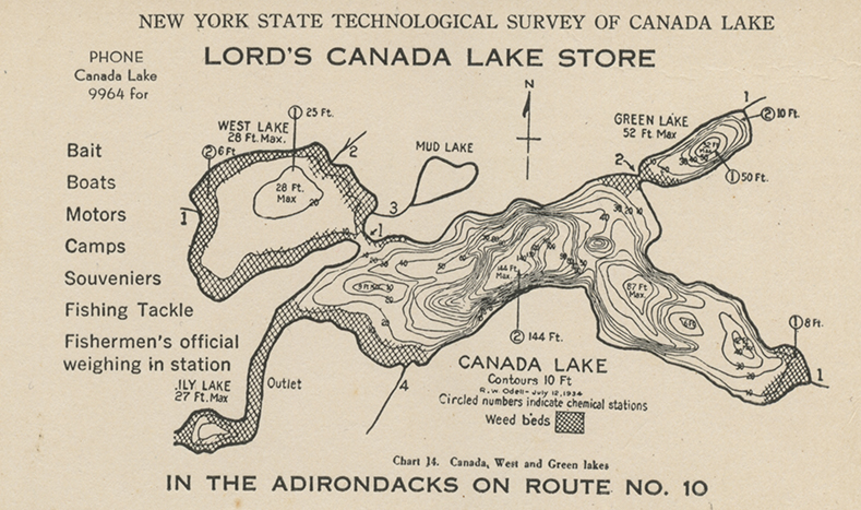
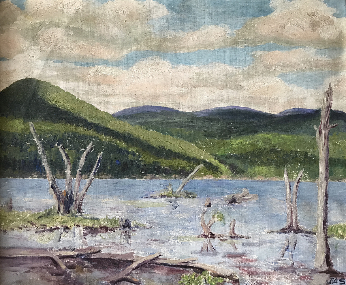
This map that was adapted by the Lords as a postcard advertising the Canada Lake Store highlights the number of weed beds that encircled the Lake. There was little open water in Lily Lake, and the west end of the Lake and West Lake had significant weed beds. The foreground of a painting from the mid 1920s by Julia Allen Streeter shows the trunks of dead trees and patches of weeds. These trees had been killed by the elevated Lake level with the construction of the dam.
Despite the attempt to stabilize the water level by the building of the new dam in 1912 and 1913, water level fluctuation over the course of a season continued to be an issue. A group of Canada Lake lot owners met on August 26, 1922 to create what would become the Canada Lake Protective Association. One of their primary issues was “to make an investigation of the rights of the lot owners with respect to the raising of water in Canada Lake.” Another painting by Julia Allen Streeter from about 1930 documents the dramatic drop in the water level, especially when it is compared to a photo of the same view taken in September, 2018 when the Lake was 1.81′ below today’s accepted summer level of 1543.1′.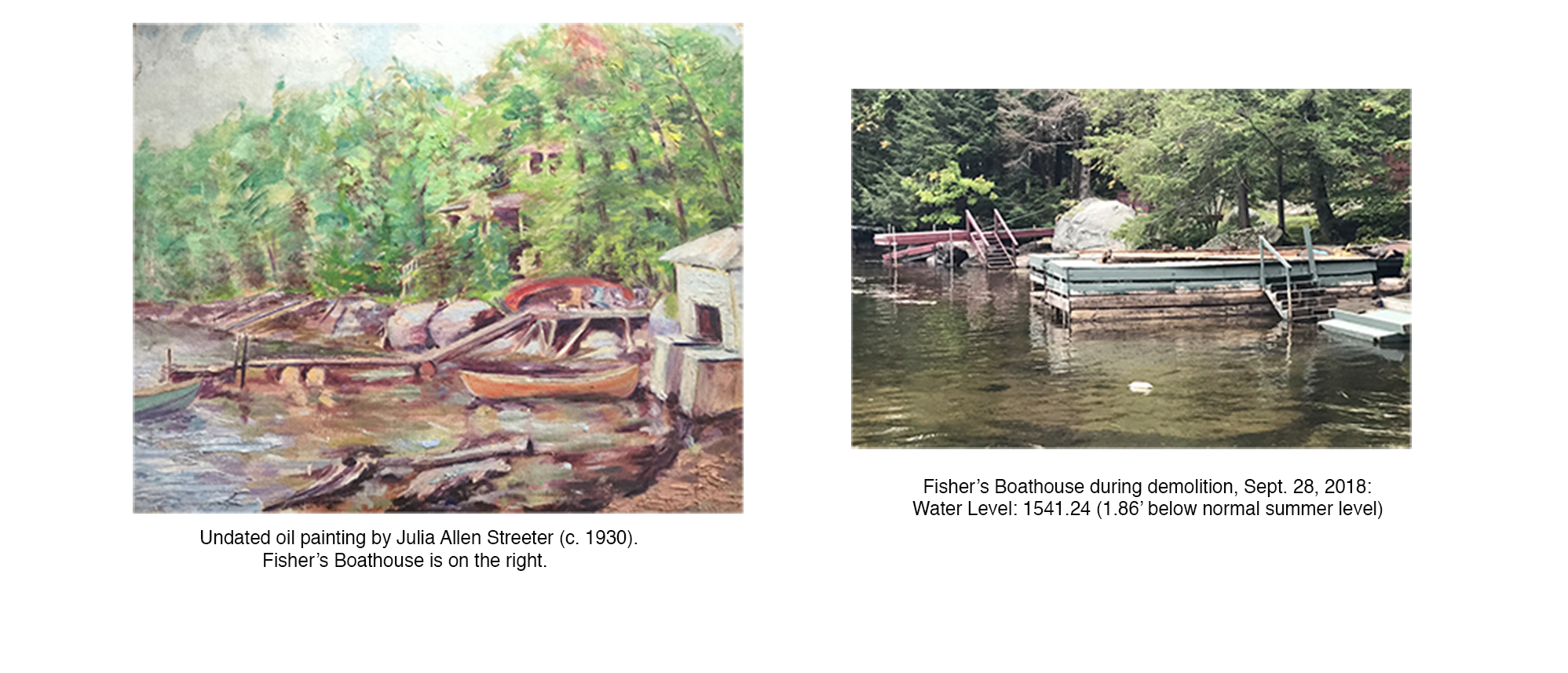 In a 1947 letter, Paul Bransom calls attention to the low water-level: “Another thing you ought to see is the lake water level now! It is like it was several years ago when we had the broad beach all around and when the lake suddenly came up three feet after the heavy rain, remember? Well, we have the same thing now except for the rain which has been non-existent for almost a month –everything is very dry and the governor has ordered all the woods closed and no hunting season (I am glad for the latter!) But, to get back to the water –at the end of your boathouse, just under your diving-board there is now just about six inches of water. You’d have to make a very flat dive now. As Aunt Grace told you we easily walked all the way around the bay and out around “Fort” Breeze point.”
The 1945 USGS Map:
In 1945, USGS published new maps of the region. Click here to see a composite of these maps. By the time of the 1945 USGS Map, most of today’s roads had been created. Most especially the highway over the mountain allowed travellers to bypass the old State Highway along the shore. Cy Durey’s vision of the Lake as a summer community has been achieved. Along the roads most of today’s camps around the Lake had been built. Much of the construction occurred during the 1920s with the majority of the camps having 75′ shorelines.
As an example of this development, in 1923, two lots were bought by the Streeter family for $1200 in Punky Cove. That fall and winter they had Burtell Foster build their camp, costing $2,631. Considering that $100 in 1923 would be equivalent in purchasing power in 2019 to approximately $1,486, the purchase of the land and the construction of the camp were bargains.
An excerpt from a 1925 letter by George Streeter gives us an idea of the expansion and nature of the community. Demonstrating his Classical training, he provides epithets for his neighbors: “Epistle“= McKenzies [Presbyterian minister living in what is now the Fisher/Smith camp]; “Epidaurus” or “Ipecac“= Streeters [George Streeter was a doctor and the asclepeion at Epidaurus was the most celebrated healing center of the Classical world; Ipecac is a plant used to make a medicine that causes vomiting after suspected poisoning]; “Epiglottis“= Scrivens [Mrs. Scrivens was a singer. Her camp is now owned by the Lessers /Youngloves]; “Epilogue“= Russells [Mr. and Mrs. Russell were moving picture makers. The camp is now owned by the Moriarty family]; “Epigram” or “Epithet” or “Epilepsy“= Dwiggins [Clare Victor Dwiggins was a cartoonist]; “Epicurus“= Hackney-Williamson [the “rich relatives” of the Streeters who owned Sand Point. They were being accused of living an Epicurean life of luxury and indulgence].
In 1945, the South Shore Trail was still sparsely populated. Most dramatically, except for two isolated dots on the south shore , no road or camps appear along the channel down to Stewarts Landing. The continuing use of the dam for power meant frequent periods of low water, especially during the late summer, and made it unfeasible to build there.
Jack Fielding’s Maps:
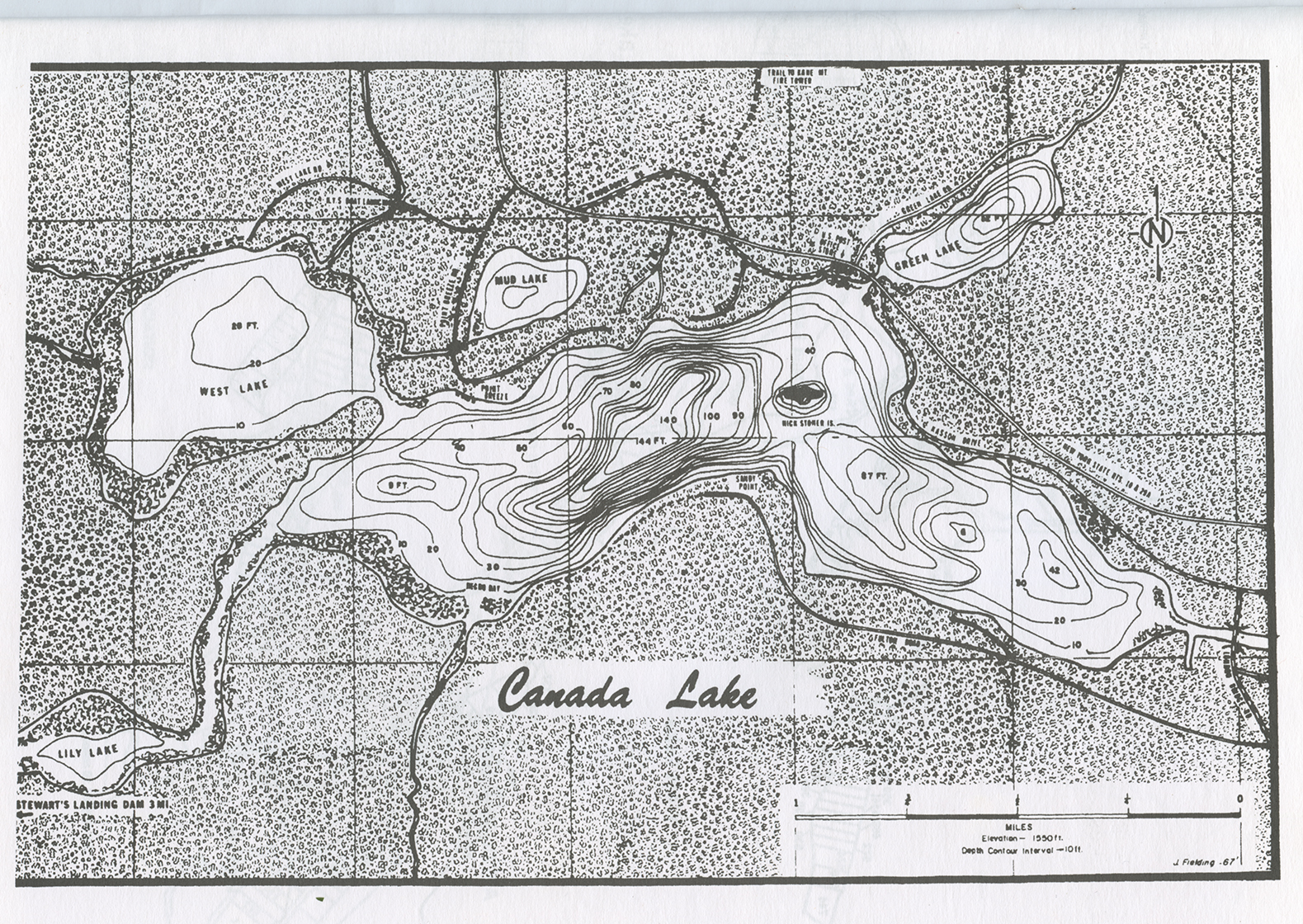 In 1967, Jack Fielding created this map of the Lake depths. This was used as the basis for the same map in the current Directory.
 In 1972, Jack Fielding created for the Canada Lake Protective Association a map of Lake property owners. This map is the progenitor of the directory maps that we have today. This map is a remarkable accomplishment considering that Jack did not have advantages of digital technology. This map gives us a glimpse of the people of the Lake’s past. To help read this map, explore the sections.
 Section 1:
  Section 2:
  Section 3:
 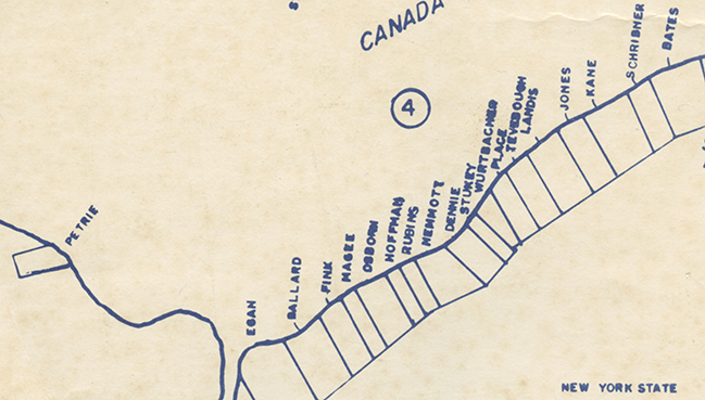 Section 4:
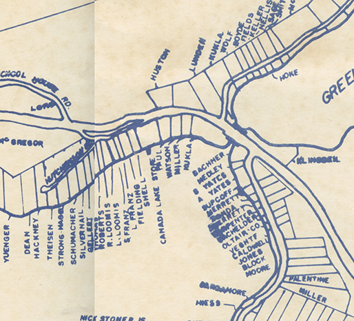 Section 5:
 Section 6:
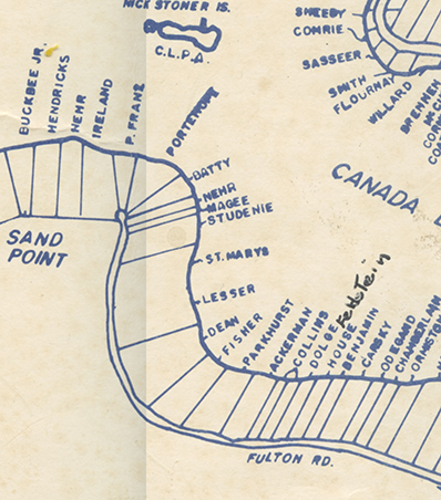 Section 7:
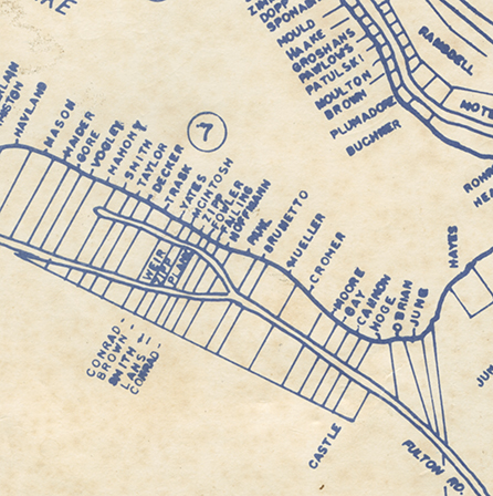 Section 8:
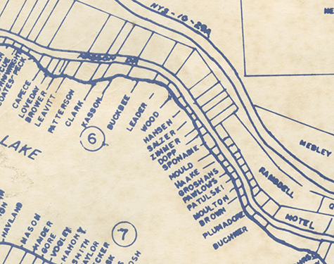 Section 9:
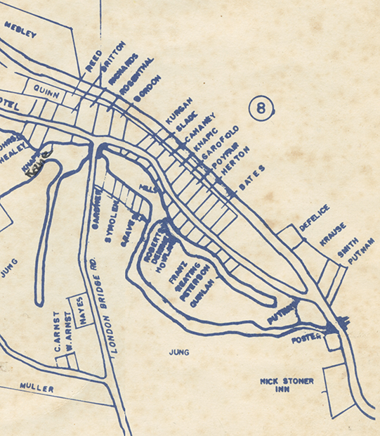
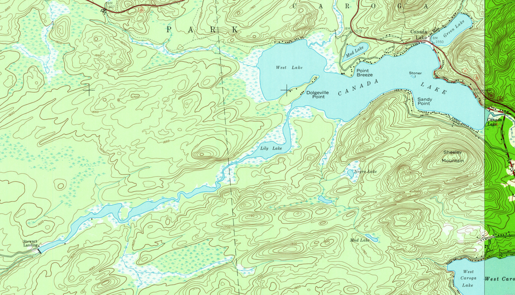
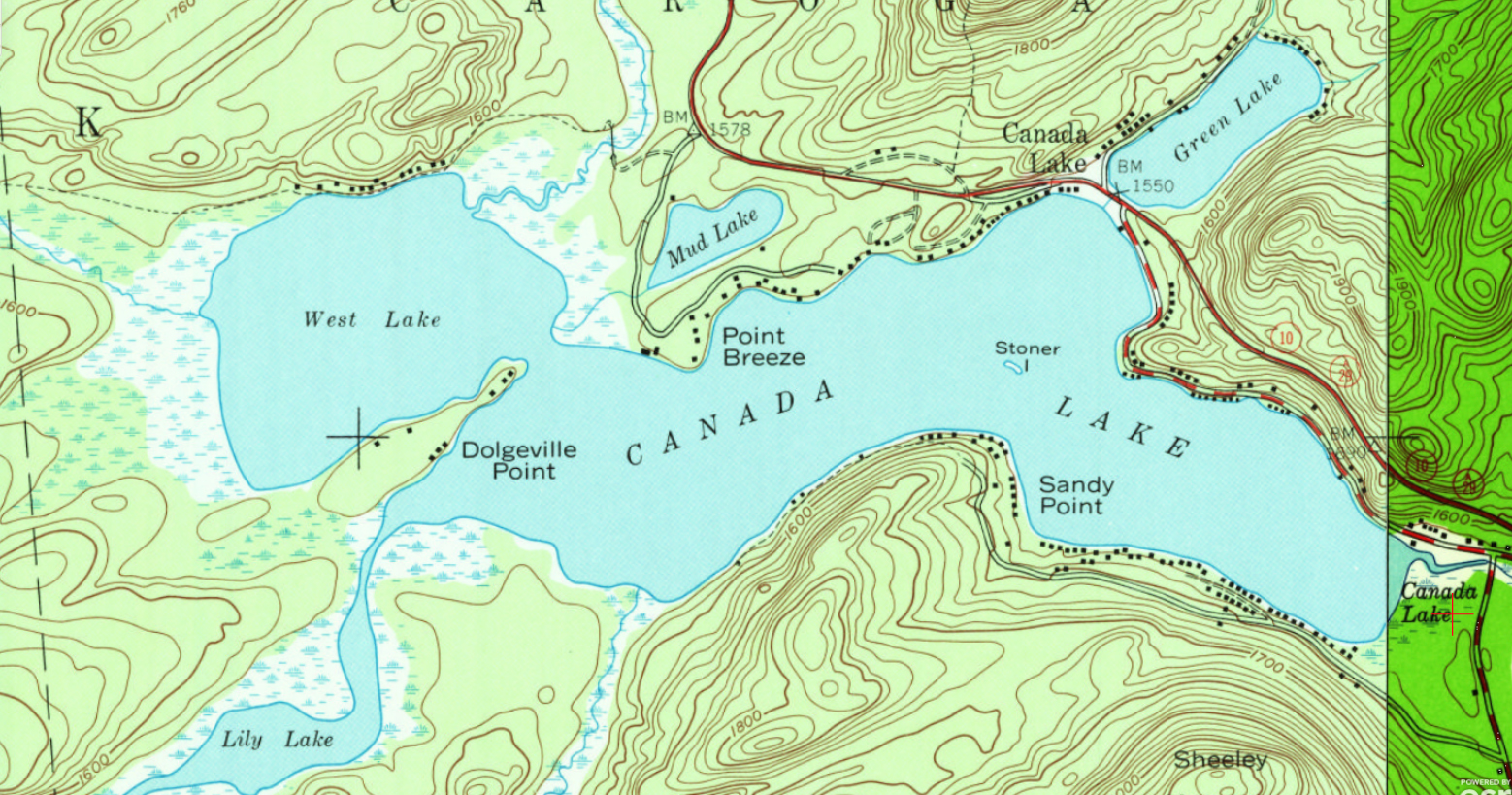
1997 USGS Map
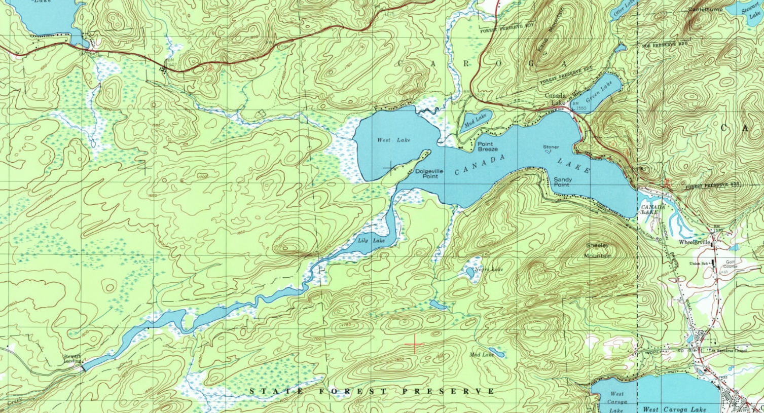
The 1997 map is largely a reissue of the 1945 map. Although the 1997 has added trails on the north and south side of the channel, none of the camps along the channel have been documented, likewise none of the development along the South Shore Trail.
Google Earth Satellite View of the Lake and Channel
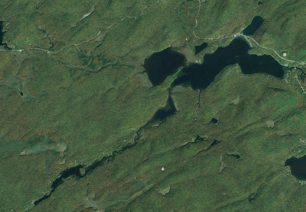
A comparison of this Google Earth Satellite view to the earlier USGS maps shows the changes in the Lake and Channel over the years. This is especially evident in Lily Lake. What were weed beds are now submerged with the lighter coloration reminding us of their earlier existence. What residents on the Channel call Turtle Island just before you reach the dam is barely a peninsula in the 1903 USGS map.