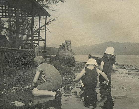
 Many thanks to Randy Fredlund, Nick Gale, and Bill Fielding for sharing their pictures and videos.
Readers are encouraged to read Randy Fredlund’s February, 2021 article in Adirondack Almanack entitled “Stewarts Landing: Long dammed but still special.”
After the weather, the most frequent topic of conversations among lake residents is the water level. Everyone has an opinion. This webpage is devoted to a history of the dams that have controlled the water level since the middle of the nineteenth century. The historical narrative is linked to pdfs of the documents connected to the dams and water level.
Detail of 1856 and 1868 Maps of Fulton County:
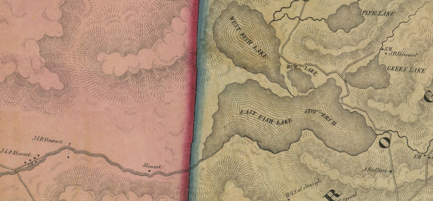
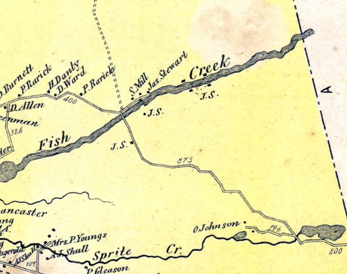
The first European settlements in western Fulton County were around rivers and streams. The settlers depended on water power for their saw and grist mills. Towns like Newkirk Mills, which is today a short bypass off of Route 10 as you approach Caroga from the south, were the center of the economic life of the period. This detail of a map from 1856 documents the existence of sawmills owned by James and Daniel Stewart along the channel leading out of what was then known as East Fish Lake. The Stewarts also owned a sawmill in the stream feeding Green Lake. A 1868 map of Stratford shows a sawmill owned by James Stewart that despite the topographic inaccuracies of the map likely is close to the site of the later dam.
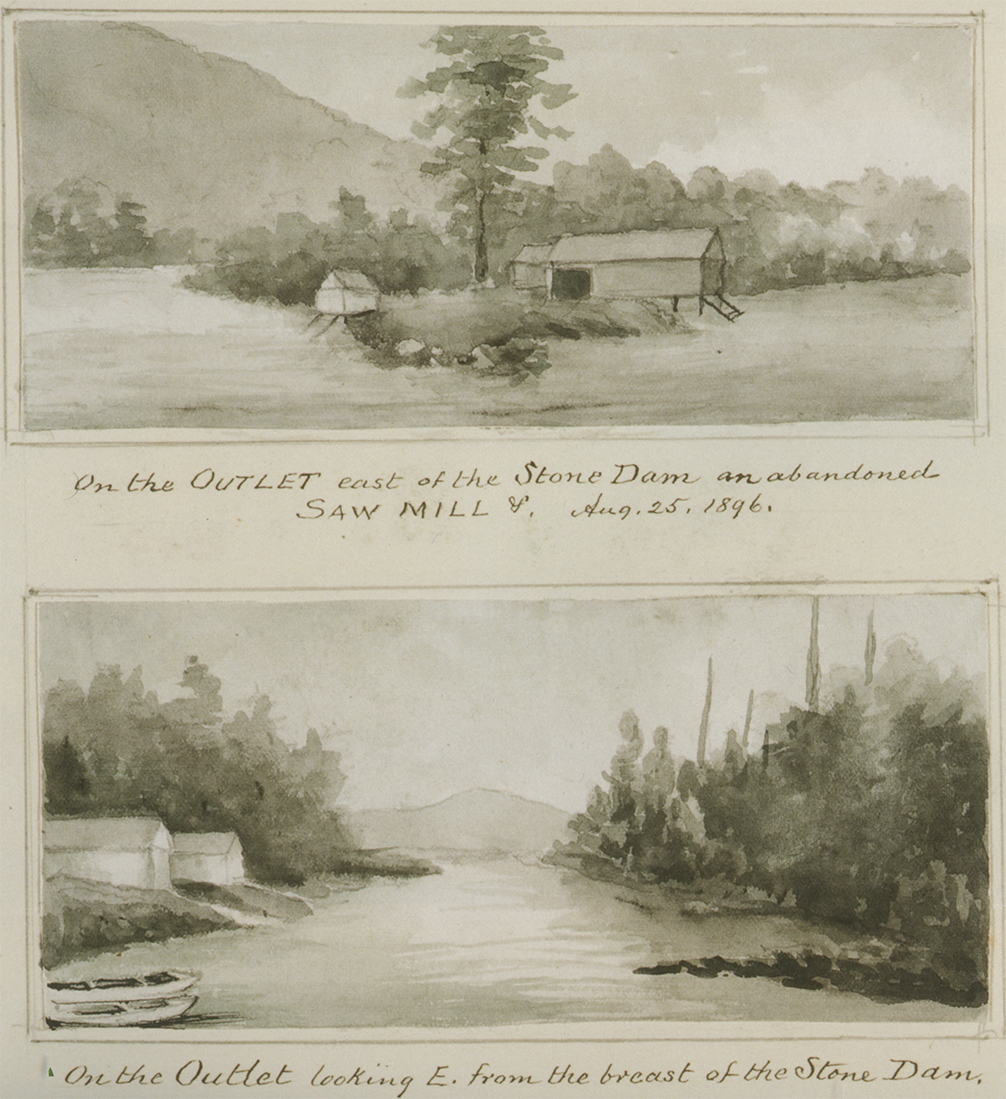
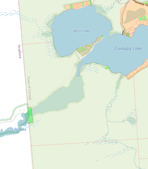
The map also records land owned by Stewart upstream where an early dam was constructed near another sawmill. Rufus Grider in his Canada Lake album includes two sketches from 1896 of the abandoned sawmill east of the stone dam. In the lower sketch can be seen the silhouette of what is likely Kane Mountain in the distance. As suggested by George Dieffenbacher in his history of the Stewart’s Landing Dam , this dam was likely located at the west end of Lily Lake at the beginning of the channel leading down to Stewart’s Landing. Later documents locate the stone dam at Lot 75 of the Stewart’s Landing Development, 1168 Stewart’s Landing Road.
Even today this nineteenth century dam has an impact on the lake. The remains of this stone dam create a restriction in the water level on Canada Lake. Below the level of this dam, the Stewart’s Landing Dam has no impact. Effectively the remains of this stone dam determines what might be considered the “natural” level of the upstream lakes. The lowest the lake got in the 2020 Leap Year early draw down was about 1540.36 feet, while the water level at the Stewart’s Landing dam was drawn down below 1536.41, the level of the tainter gate, to facilitate the replacement of the sill.
1897: Alfred Dolge Dam:
In 1897, Alfred Dolge built a larger dam. This new dam was used to power a saw mill and to improve navigation on the channel to enhance travel to the lakes from the west. In a deed dated May 1, 1897, Dolge grants to Caroga Land Company:
“The right to raise the water in the lake known as the East Canada Lake and the other lakes, bodies and streams of water connected therewith and adjacent thereto, not to exceed six feet perpendicularly above the present average high water mark, and to flow such part of the lands above conveyed as may be necessary for that purpose, and to build, erect and maintain all necessary dams, embankments and other erections, constructions and appliances as may be necessary for that purpose and to maintain the water at such height above the present average high water mark of said lake as the parties of the first part [Dolge], their heirs and assigns may see fit, and to flow such part of the land above conveyed, at all times….
“It is further understood, covenanted and agreed that Alfred Dolge, one of the parties of the first part, will within three months from the date of this instrument, locate permanently the proposed dam or dams and determine the flow line of the lands, the right to flow, which is reserved in and by this instrument above mentioned and referred to, and to cause to be made maps and profiles thereof…to make and execute in due and legal form an instrument in writing locating said dams and defining said flow lines, which instrument may be filed and recorded….”
As a fulfillment of this agreement, the surveyor George Seidl together with J.W. Miller produced for Alfred Dolge in 1897 a map of the lake documenting the so-called “flow line” around the lake. This line drawn in red demarcated the elevation 1545′ which marks the high water mark on the cottage lots around the lake. Dolge and the Caroga Lumber Co. agree to keep the water level below this line. This agreement will be continued when Cyrus Durey and the Durey Land & Lumber Company succeed. References to this Seidl map with a “red line” will be found in many of the deeds of lake properties.
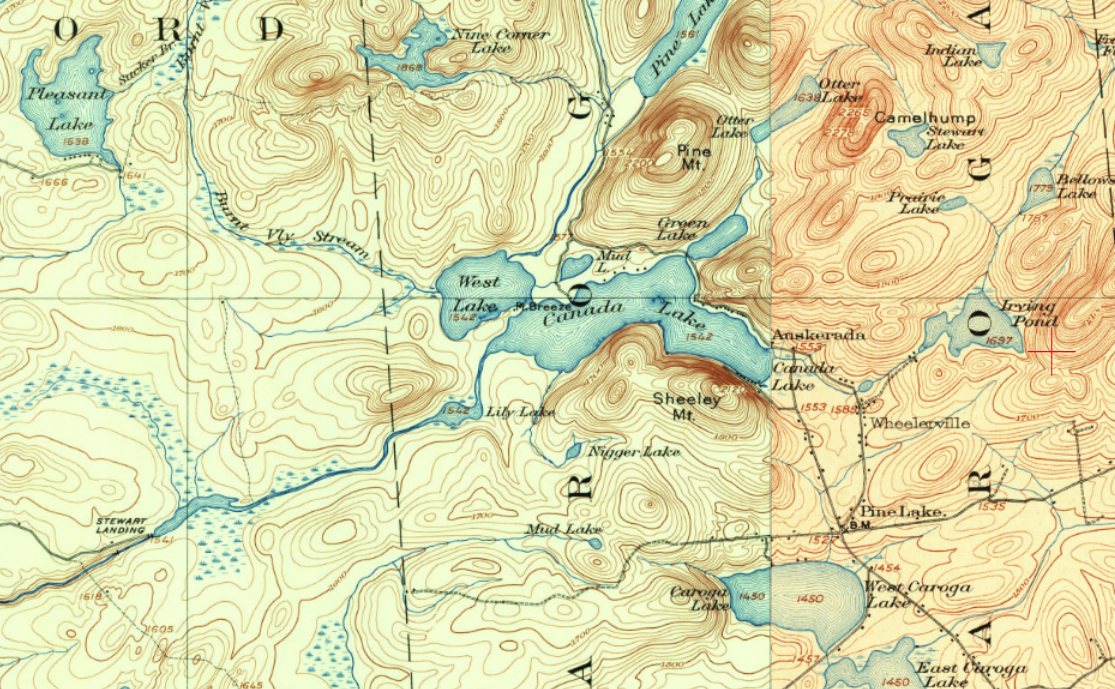
Navigation was a central concern for Dolge. In 1897, Dolge incorporated the “Auskerada Park Club.” His ambition was to develop the land he had acquired around the Canada Lakes into cottage lots. So access to Canada Lake was critical for the success of his project. While road access from Johnstown and Gloversville as well as from the Mohawk Valley towns to the south had already been opened up, there was no easy access from the west including Dolgeville. As documented by the 1901 USGS map, the road from the west ended at Pleasant Lake and only a trail leading from there to Pine Lake. At the August 1903 meeting of the East Canada Lake Protective Association, a special committee was formed to work on getting a road to connect Stewart’s Landing with the road in Stratford. The creation of a dam at Stewart’s Landing and raising the water level to allow for better navigation of the narrow and at places shallow channel was critical. As recounted by Margaret Vosburgh:
Everything came up from Stewart’s Landing, even building materials. Once a rowboat loaded with brick sank in the channel. Wagons loaded with people and supplies left Dolgeville in the early morning, and four to six hours later they arrived at the Landing. The rest of the day was consumed in the long, hard row up the channel. (McMartin, Caroga, p. 98)
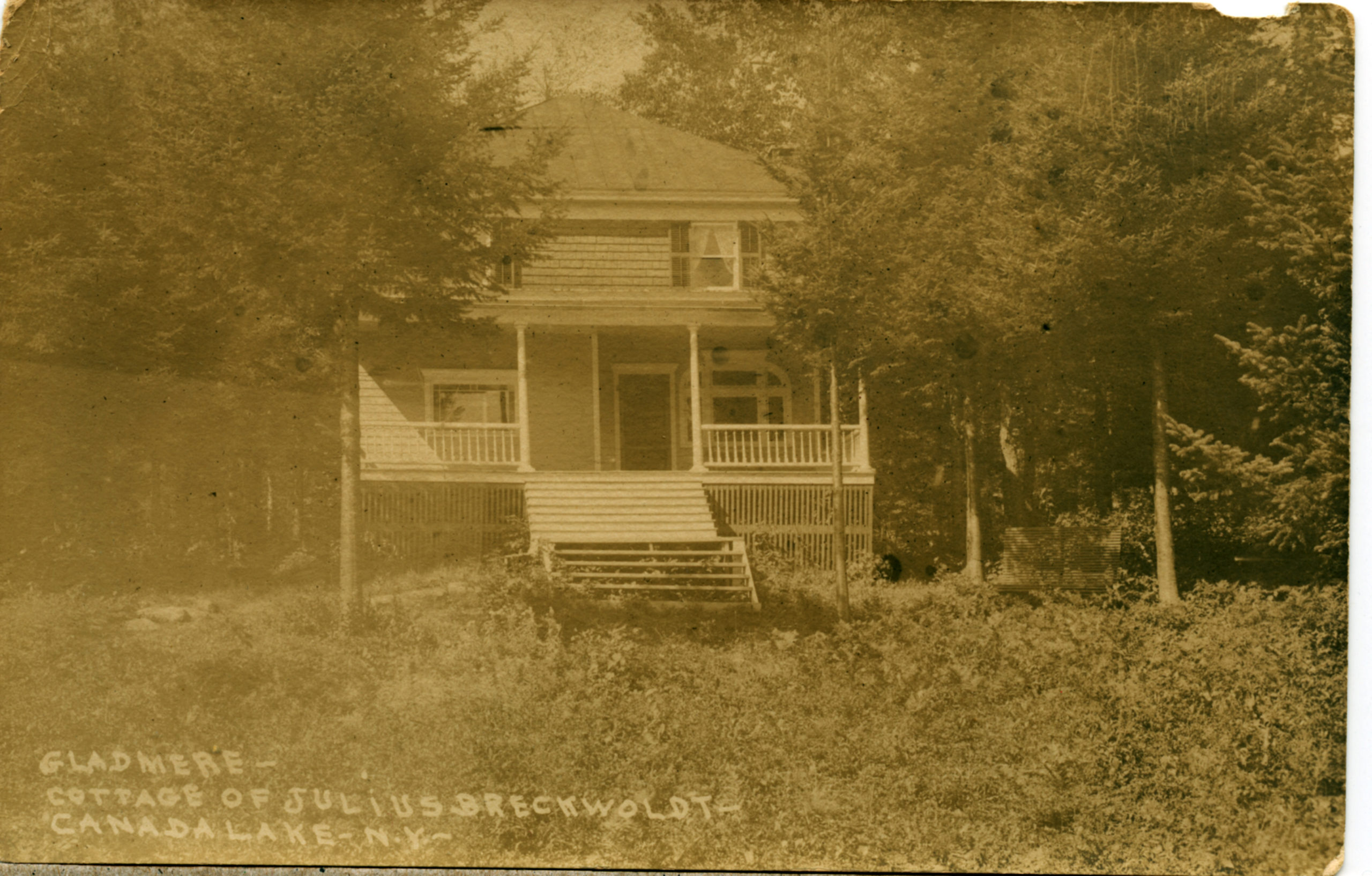
This access up the channel to the lake helps to explain how even today many of the owners of properties on Dolgeville Point have ancestral ties back to families rooted in Dolgeville. For example, Margaret Vosburgh was granddaughter of Julius Breckwoldt, a prominent businessman and banker from Dolgeville. Margaret’s family still owns the Dolgeville Point camp built by Julius.
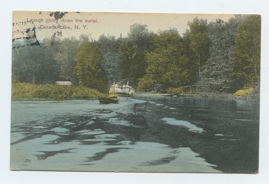
The 1890s and the first decades of the 20th century was the era of the steamer throughout the Adirondacks. Steamer rides from the hotels on Canada Lake to Stewart’s Landing were a very popular excursion. Descriptions of steamer rides were included in local articles touting the glories of a visit to Canada Lake: “A steamer ride down to ‘Stewart’s dam’ and back will leave a photograph on your memory that will never fade and as you can never see this particular place again, go now. It is only twelve away. ” But the steamers were clearly valued in improving travel to the lake from Dolgeville. The Johnstown Daily Republican for June 30, 1897 includes the following notice:
The Auskerada Park club of Dolgeville, writes a correspondent in that village, have made arrangements whereby the steamers will come from Canada Lake to the Stewart mill and thereby avoid the long row formerly necessary to get to the lakes. The Dolgeville telephone company have strung wires all the way up to the Auskerada hotel, and communication can be had by this means between Dolgeville and the lakes.
The 1890s witnessed the creation of local power companies. On May 1, 1897, Alfred Dolge along with his wife executed a lease with the Dolgeville Electric Light and Power Company to construct a dam across the East Canada Creek at High Falls., and a power house. A December 22, 1897 article in the Johnstown Daily Republican heralds the completion of the so-called High Falls dam and power plant on the East Canada Creek in Dolgeville. The article identifies Alfred Dolge as “the pioneer in the movement of transferring water power into electric power in distant places…, and for many years he has been using electrical power to run his factories in the village of Dolgeville.” The April 1898 issue of the American Electrician provides a detailed account of this dam and power house. An article recounting the sudden bankruptcy of Dolge from the April 15, 1898 issue of the The Otsego Farmer gives an overview of Dolge’s business ventures. The article recounts Dolge’s acquisition of “over 40,000 acres, on which are hundreds of lakes, all available to be used as storage reservoirs” to power the High Falls dam. “One of the largest purchases was the land surrounding the Auskerada lakes [Dolge’s name for the Canada Lakes]. This chain of lakes is one of the beauty spots of the Adirondacks and forms the headwaters of the east branch of the East creek. The lakes so situated that the water covering several thousand acres could be raised several feet and thus form a storage reservoir for his Dolgeville water supply.” It is not clear how many of these storage reservoirs were actually constructed before Dolge’s financial collapse. An application for the “Voluntary Dissolution of the Dolgeville Electric Light & Power Co.” was filed with the New York Court of Appeals on November 21, 1899. The High Falls plant would be taken over by the Utica Gas and Electric Company which in turn became part of Central New York Power and Light.
1901 USGS Map:
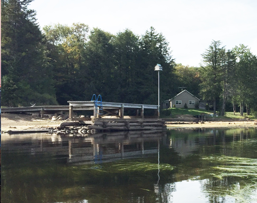
The 1901 USGS includes the “Stewart Landing” dam and records the elevation as 1541 while Canada Lake’s water level is listed as 1542. Judging by the relationship of the dam to the topographic features on either side, the dam in 1901 appears to be further upstream from the current dam. An article dedicated to the later 1924 dam records the earlier dam as being a “timber-crib rock filled dam,” 1,600 feet upstream of the new dam. The likely remains of the cribbing of this earlier dam are still visible today as the foundations of a modern dock:
A photograph of the late 19th century “timber-crib rock filled dam” at Irving Pond perhaps gives us a sense of what the earlier dam at Stewart’s Landing might have looked like.
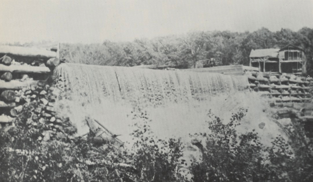
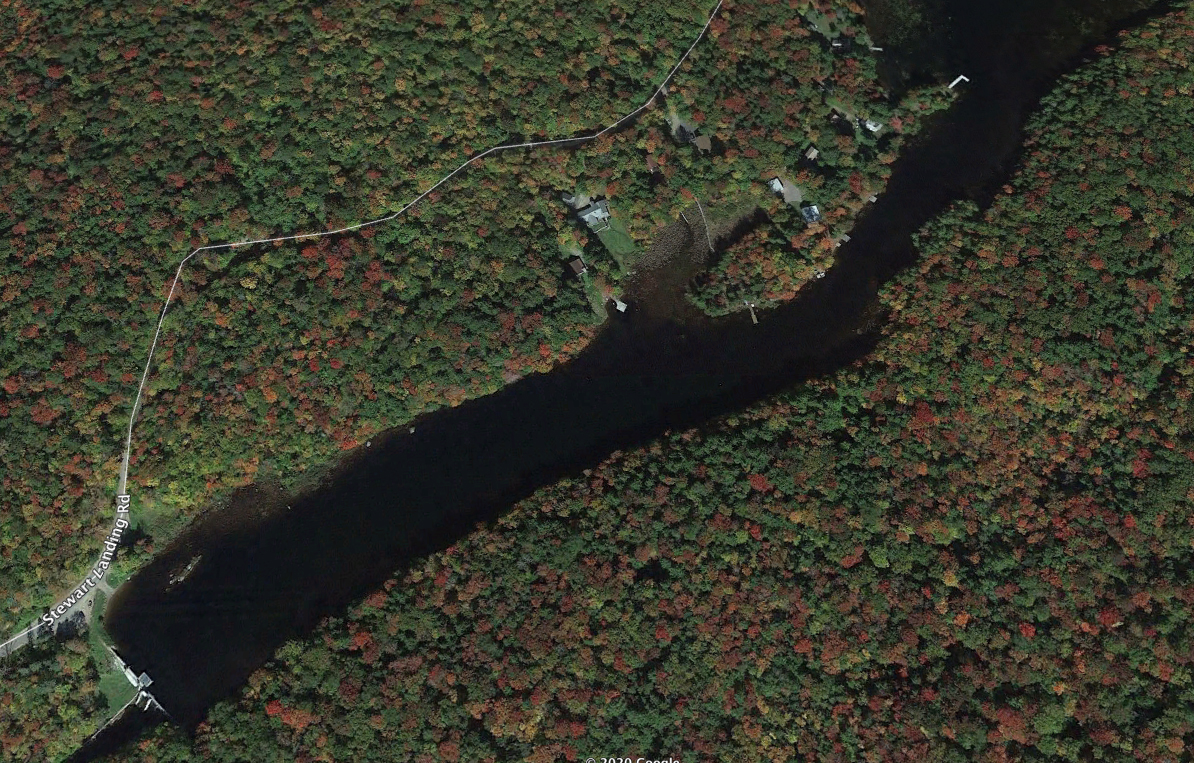
A Google Earth view of the area around the current dam shows the location of this earlier dam in the upper right corner of the photograph. The “L” shaped modern dock at the eastern, upstream end of a narrows leading to the current dam marks the likely location of the Durey dam. This appears to be at least close to the location of the Stewart Landing dam recorded on the 1901 USGS map.
1902-1907: James C. Livingston owned “Stewart mill property”:
Johnstown Daily Republican for September 25, 1902, reports the acquisition by James C. Livingston of the large tract of land formerly owned by Alfred Dolge known as the “Stewart mill property” at auction for $20,030. Livingston was bidding against Cy Durey. As early as 1897, Livingston had been acquiring land in Stratford. By 1904, Livingston had erected a sawmill on the outlet of Canada Lake, near Stewart’s Landing. In April 1904, the J.C. Livingston Company of Utica, the maker of parts of musical instruments and other woodworking business, was incorporated with capital stock of $100,000. A 1906 article identifies James Livingston as a “manufacturer of piano sounding boards and a dealer in lumber…probably the largest business of the kind in the country.”
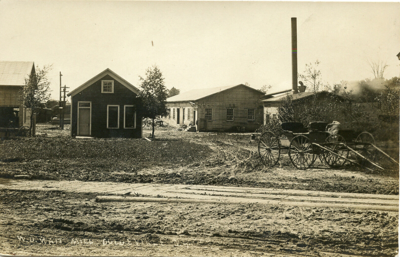
1907: W. D. Watt company acquires Stewart’s Landing:
The March 15, 1907 issue of the Utica Herald-Dispatch, announces the formation of the Watt Lumber Company: “The new company will take over the holdings of J. C. Livingston at Stewarts Landing near Canada Lake, and will continue the lumbering operations as now conducted there, including the running of the sawmill.” The Johnstown Daily Republican, for March 21, 1907, records the sale of land in Stratford by James C. Livingston to W. D. Watt Manufacturing company of Little Falls.

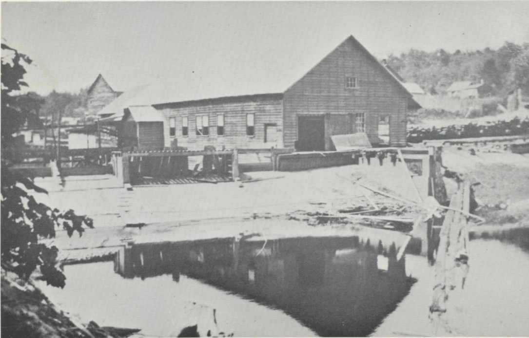
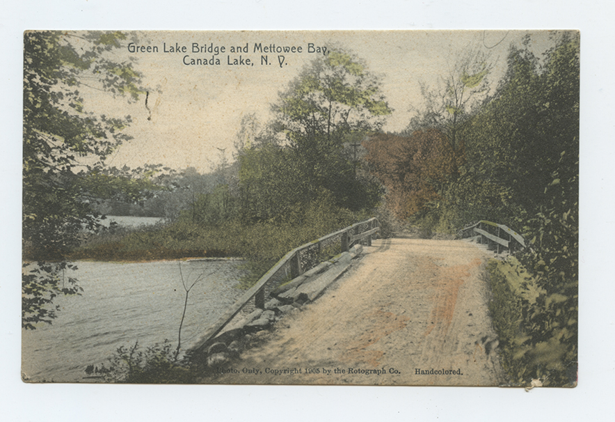
A postcard from 1907 shows “The W.D. Watt Lumber Co., Stewerts [sic] Landing, Stratford, N.Y.,” and documents the viability of the lumber industry in the first decade of the 20th Century. The Utica Herald-Dispatch article also announces the intention by the Watt Lumber Company to build a sawmill and lumber yard in Dolgeville. This “W.D. Wait [sic] Mill, Dolgeville, N.Y.” shown in a real photo postcard:
A May 24, 1915 article reports that the W. D. Watt Manufacturing company in Dolgeville was sold at auction. It is noted that the factory had been “idle lately.” There is no word about the Stewart’s Landing sawmill.
1912 & 1913: Cy Durey Constructs New Dam (?) and East Creek Light and Power Company:
In October, 1904, Cy Durey and the Caroga Land and Lumber Company acquired at a bankruptcy sale the Canada Lake property of Alfred Dolge. In 1912, the Caroga Land and Lumber Company became the Durey Land and Lumber Company. Durey, while continuing the lumber business, became engaged in the development of Canada Lake with the sale of cottage lots. As part of the development, he was particularly interested in developing the roads. Another concern was water level. James Y. Fulton, the owner of the Canada Lake House and who was involved in the steamer business, complained that the lakes became “unnaturally low in the summer season to the injury and annoyance” of summer residents. A postcard from 1905 of Fulton’s Canada Lake House documents the low water at this time:
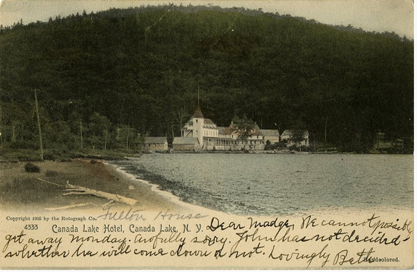
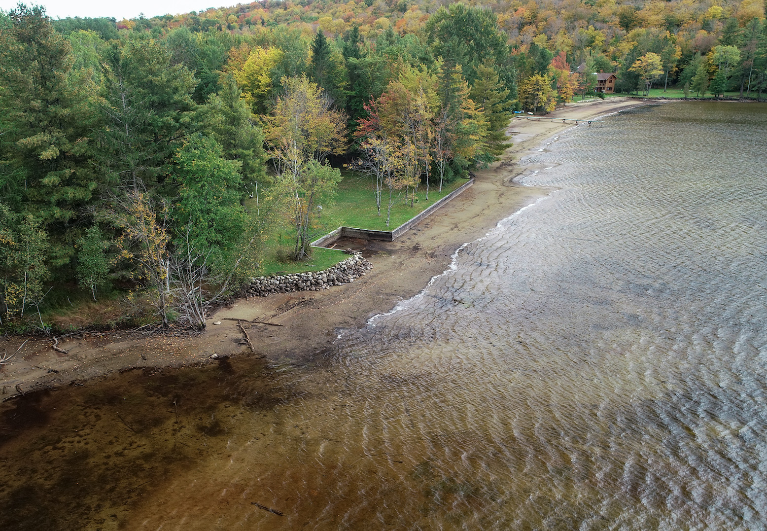
An aerial view of the same beach taken in the fall of 2020 when the lake was drawn down closer to its natural level documents the dramatic impact of the elevated water level due to the dam. The log in the foreground of the postcard can possibly be still identified in the 2020 drone view. It could be one of the many well-preserved logs lying at the bottom of the lake that are reminders of the tanning and lumber industries of the past. When the lake is at today’s normal summer level, it laps against the timbers and riprap added to protect the vulnerable shoreline from erosion.
A postcard from before 1913 of the island shows a rock that is today usually submerged just off the current dock:
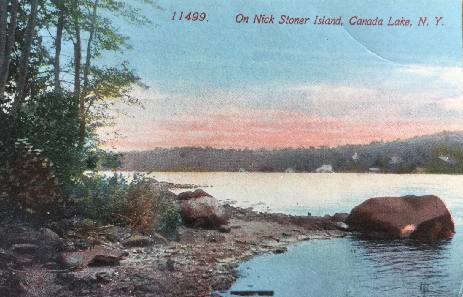
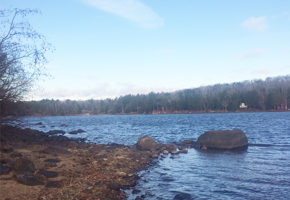
For comparison, the photo above was taken on November 21,2020 when the water level at the Green Lake Bridge was measured at 1540.38′, or 2.72′ below the current accepted summer level of 1543.1′. The photo documents how much erosion has occurred over the last hundred years. A medium size rock that appears in the postcard to mark the edge of the beach is today detached from the shoreline. When the lake is down to winter level which is close to the natural level without the dam, the lake is ringed by beaches. These beaches play an important role in dissipating the erosive force of the wave action.
An article in the Fulton County Republican, August 8, 1907, entitled “Low Water at East Canada Lake Worries” documents the regular concerns of low water:
The members of the East Canada Lake Protective Association held a special meeting at the Auskerada Lake hotel at Canada Lake Saturday afternoon. Among the matters that were taken up for consideration was the low water condition of the lake, it being alleged that the water at Stewart’s Landing, the outlet is allowed to flow off for the purpose of floating logs of such an extent that it leaves the boat houses high and dry along the shore and the boats beached in the mud. A committee was appointed at the meeting Saturday to look into the matter and some action will probably be taken shortly.
Just as there were concerns about low water, there were also concerns about high water. An article dated June 13, 1907 entitled “Canada Lake Notes” in The Broadalbin Herald reports that “mill owners on the outlet have raised the dam some 12 inches. If so, they will probably find an injunction asked for.” A legal decision from the 1850s was seen as “a precedent that the Canada Lake association relies on to keep the lake from being flooded, to the detriment of cottagers and landowners on its shores.” It is interesting to observe that these articles both from 1907 and only two months apart document the extremes of water level conditions during this period. The mills would want to maintain high water levels in the spring and early summer to insure that they will have the flow for floating logs during the dry period in late summer.
On August 2, 1912, Cy Durey signed an agreement with Nelson H. Anibal, a prominent Gloversville lawyer and owner of the Auskerada, and 62 cottage owners on Canada Lake granting:
“…unto the said Durey Land and Lumber Company, its successors and assigns, the right to erect and maintain a dam over and across the said outlet of said lakes and the right to raise the water in said lakes as necessitated by said dam up to the high water mark on the property owned by us and each of us respectively as shown by a red mark, or line, upon a map of cottage lots filed in the county Clerk’s Office by the Caroga Lumber Company made by J. W. Miller, C.E. from the maps and survey made by one Seidl for Alfred Dolge and the Caroga Land Company and to maintain the water at said height and draw down the same without any claim or claims or damages against said Durey Land and Lumber Company by us or any of us. It being agreed by said Durey Land and Lumber Company that the water of said lakes shall be kept at least one foot higher than the present low water mark.”
This agreement is written into many of the deeds for properties around the lake as for example the Paul and Janice Corr deed:
Grants to Durey Land and Lumber Company, its successors and assigns, the right to erect and maintain a dam over and across the ***outlets of *** (Auskerada or Canada Lake, West Canada Lake, and Green Lake), and the right to raise the water in said lakes as necessitated by said dam up to the high water mark on the property owned by each respectively as shown by a red mark, or line, upon a map of cottage lots filed in the County Clerk’s Office by the Caroga Lumber Co., made by J.W. Miller, C.E., from the maps and survey made by one, Seidl for Alfred Dolge and Caroga Lumber Co. and to maintain the water at said height and draw down the same without any claim or claims or damages against Durey Land and Lumber Co. by us or any of us. It being agreed by said Durey Land and Lumber Co. that the water of said lake shall be kept at least one foot higher than the present low water mark.
This agreement documents how Cy Durey and his Durey Land & Lumber Company continued the easement granted to Alfred Dolge and his Caroga Lumber Co. to control the water level.

Cy Durey’s desire for a more stable water level coincided with the needs of the growing hydroelectric power industry. Among the local power companies was the East Creek Electric Light and Power Co. which owed its origins to Guy Beardslee who originally wanted to build a hydroelectric power plant on the East Canada Creek to power his family farm. In March of 1898 switches were thrown at Beardslee Falls Hydroelectric Plant to energize the line to St. Johnsville. A post card documents the Beardslee Falls Plant as it was rebuilt in 1903. This dam would be replaced in 1923 by a new hydroelectric plant on the west side of the creek. A December 12, 1923 article in the Schenectady Gazette describes the construction of this new dam.
An article in The Johnstown Daily Republican dated March 16, 1911 describes in great detail the creation of a new dam constructed by the East Creek Electric Light and Power Co. at Ingham’s Mills. Clearly this was seen as a testament to the advances of technology. The article goes on to say, “The physical features of the development are very favorable for the generation of cheap and reliable power, which should prove a great stimulus to the industrial activity of the towns through which the East Creek transmissions lines will pass.” While not referring specifically to Stewart’s Landing, the article mentions the ambition of East Creek Electric Light and Power Co. to meet the steadily growing demand for electric power “to acquire land and water rights for the construction of additional hydro-electric plants.” A 1909 article focusing on the start of the Ingham’s Mills project mentions Guy Beardslee’s ambitions of acquiring land along the East Canada Creek for power plants.
By at least 1913, Durey and Beardslee had reached an agreement to create storage dams in the Canada Lake watershed. An article in the St. Johnsville Enterprise, dated May 7, 1913, is entitled “Storage Dams on Lakes Emptying into Canada Lake: East Creek Light and Power Company Arranges for a Water Supply in Dry Season” The article states:
on good authority that the Durey Land & Lumber Company has disposed of a large share of water rights on the streams and lakes in its holding of many thousands of acres to East Creek Light & Power company, and this company proposed converting a number of smaller lakes into reservoirs to hold water and insure sufficient flow during the dry weather to successfully operate its plant at High Falls, south of Dolgeville.
The article states that there were already contracts with the Durey Land & Lumber Company for construction of dams at the outlets of “Nine Cornered lake, Otter Lake, Stink [Stoner], and Bellows Lake.” The article does mention how James Y. Fulton is counting on the storage dams to help maintain the lake at a more uniform depth “that will make less difficult the operating his steamer from the hotel to Stewart’s Landing and back.”
This agreement between Durey and East Creek Electric Light company is reported in a Gloversville Morning Herald article of June 13, 1913:
The Durey Land and Lumber company, of which Cyrus Durey, collector of Internal Revenue, is president, has commenced the construction of four dams at the outlets of as many lakes north of Canada Lake and contracts for five or six more will be awarded this summer. The dams are being built by the East Creek Electric Light company and are to regulate the flow of water into Canada Lake to High Falls where the power plant is located. This company has purchased from the Durey company the water rights on all of the thirteen lakes lying north of and emptying into Canada Lake as well as the water rights along contributary streams.
For years there has been low water during the summer at High Falls and difficulty was experienced in getting out sufficient power to meet the demands on the company. With these new dams in operation, an even flow of water will be assured, even during the time of greatest drouth. The dams under construction at present are at Stink Lake, Nine Cornered Lake, Middle Lake, and Otter Lake.
The Morning Herald article goes on to say how “many residents of the Glove cities” who are summer residents of Canada Lake “…will be benefited by the higher water in this lake during the dry summer months. The increased flow during the hot weather will also make sure that the daily trip of the steamer to Stewart’s Landing and return.”
A deed dated December 31, 1920 between Durey Land and Lumber Co. and Adirondack Power and Light Corporation which had succeeded East Creek Electric and Light Corporation confirms the earlier agreement between Durey Land and Lumber and East Creek. The agreement allows the power company to build and maintain dams “for the generation of electricity, either upon the lands described, or by storing up of water and releasing the same to be used elsewhere by the Power Company.” Durey Land and Lumber retains the rights “to use the same for lumbering purposes, including the piling of logs, manufacture and storing of lumber, and the right of maintaining and removing any and all buildings or mills that may now or hereafter be located on …[the] land.” The deed specifies dams on Lily Lake, Nine Cornered Lake, Bellows Lake, Fry’s Flow, Pine Lake, Irving Pond, and the outlet and stream from the Stoner Lakes.

The attached property map for the Town of Caroga shows a property at the east end of Lily Lake highlighted in bright green that is connected to the 1920 deed. The search packet identifies this property as “Beardslee & Inghams Developments East Canada Creek Project.” Durey and East Creek Electric Light and Power Company had apparently agreed that this would be the site of a new dam. There is no evidence that this dam was ever constructed. In a 1947 lawsuit there is the following testimony of Jacob Unger:
Q. Do you know there was a dam at Lily Lake, was that right. A. At Lily Lake a dam.
Q. Yes. A. No, sir, I never knew there was no dam upon Lily Lake or anybody else.
Q. You are not familiar with the dam that was built there by the East Creek Electric Light and Power Company. A. Yes, I know where that is.
Q. That dam raised and lowered the waters of the lake. A. Yes.
Q. Was that right. A. Yes
Q. When the level was at its lowest point that is down to the regular level of the lake. A. There was no dam in Lily Lake, that I ever saw down there.
Q. Where is the dam. A. There was a dam down below, a stone dam down below, that was built before, I was a child.
This stone dam that Jacob Unger refers to is probably the 19th century dam a little further downstream at Lot 75 of the Stewart’s Landing Development, 1168 Stewart’s Landing Road.
Interestingly neither the 1913 articles nor the 1920 deed make mention of the construction of a dam at Stewart’s Landing. Beardslee’s plan to build a dam at Stewart’s Landing is suggested by the listing in the 1966 deed marking the sale of Stewart’s Landing dam to the Oregon Mountain Corporation of three properties in the area of Stewart’s Landing acquired by Guy Beardslee in 1913. An article in the St. Johnsville Enterprise dated September 20, 1914 is entitled “Improvements at Stewart’s Landing: New Dam Has Been Built on Durey Lumber Co.’s Property. Other Improvements.” The article reports that “a new dam has been built on the site of the old with bulkheads four feet higher and a much longer spillway.” This suggests that the Durey / East Creek dam was built on the site of the Dolge dam. The article goes on: “The water under the new arrangement will be two feet higher than it was before and the channel will be deepened to such an extent as to afford a much easier passage to the main part of the lake. Five of the chain of lakes to which Canada Lake belongs have now been equipped with dams which makes power conditions better at point below the lakes on the East Canada Creek. ” In 1914 there is also reference to the construction of a dam at Pine Lake.
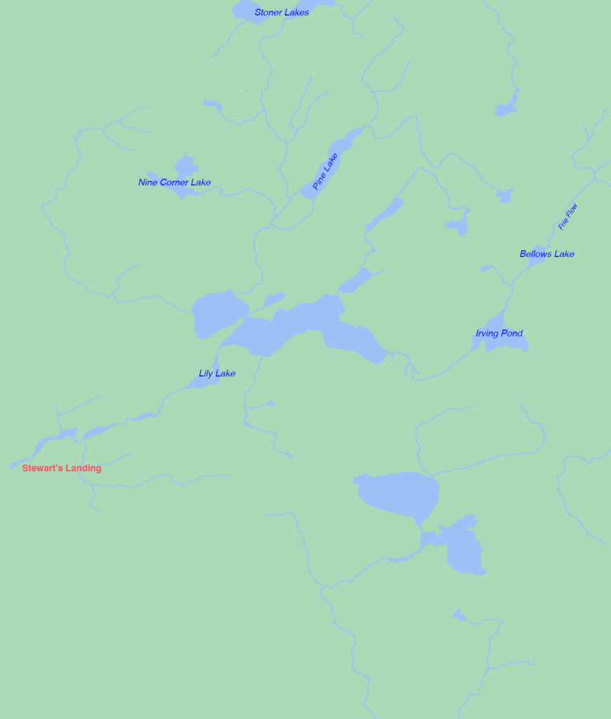
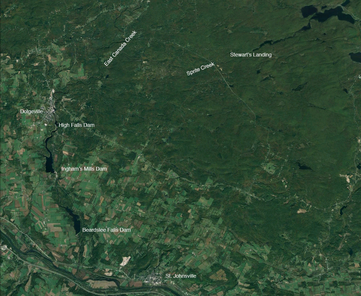
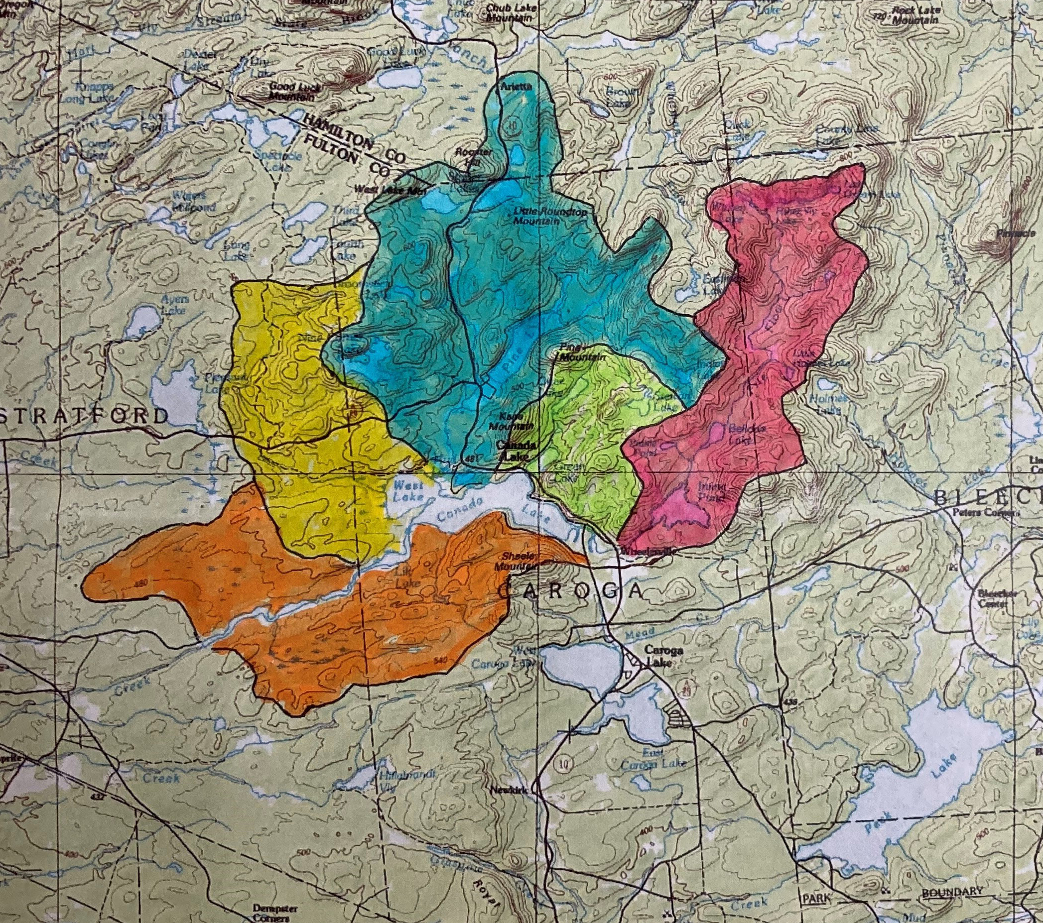
The map above identifies the different storage dams referred to in the 1920 deed which confirmed the earlier agreement between Durey and East Creek. The construction of these dams was intended to control the Canada Lake watershed.
1914: Eberly Hutchinson rebuilds lake road:
Long time Canada Lake resident and civil engineer, Eberly Hutchinson along with Burt Kasson was hired to construct “the macadam highway along the old road on the shore of Green Lake from Stony Point to the sawmill.” A 1947 lawsuit concerning the ownership of properties at the Green Lake end of what is now Kasson Drive includes testimony by Eberly Hutchinson which provides valuable information about the water level in 1914. Hutchinson described the old road that they replaced as a causeway “built up of cribbing, corduroy and with stringers.” The land around it was swamp with hummocks and the greater part of the area had standing water. The remains of this 1914 macadam road are perhaps still visible at the end of Kasson Drive and across the channel. The remains of the earlier Green Lake Bridge, which would connect these two roads, can still be seen. The still existing wetlands on the north side of the channel give us a sense of what the land at the northern end of Kasson Drive would have looked like in 1914.
Hutchinson had recorded different water levels in his field book while surveying the road in August, 1914. He listed the water level as 1541.35′ on the day he took the survey. The old corduroy road at its highest was 1543.30.’ In planning the new road he made the level of the pavement 1544.75.’ Even with the water level at 1541.35′ the causeway was surrounded by standing water (pp. 257-258). Later in his testimony, he is asked about the current water level. Eberly Hutchinson testifies that on October 2, 1943, the previous Saturday from his testimony, “the marks on my dock and the gauge at the bridge [were] showing 1540.4.” He acknowledged it was “very much” lower than usual (pp. 277-78). Testimony in the lawsuit repeatedly makes the point that the accepted water level on Canada Lake since the USGS Survey of 1901 is 1,542′ (p. 44).
1918: Cy Durey sells Forest Lands to the State of New York:
Cy Durey sold to the State of New York for $4.00 per acre undeveloped land “for state park purposes.” Included in the agreement is an easement for “the East Creek Electric Light and Power Company to construct, maintain, and operate, and from time to time as may be necessary to rebuild a dam across the outlet of Lily Lake, so called, and to raise thereby the waters in East Canada Lake, West Canada Lake, Lily Lake and Green Lake….” The terms of the 1912 agreement between Durey Land and Lumber Company and Nelson H. Anibal are included in the easement.
The deed also acknowledges:
“…the right of the East Creek Electric Light and Power Co. to construct, maintain, and operate a hydroelectric plant for the generation of electricity at the dam site above excepted, and build, maintain, repair, enlarge or modify any or all structures, fixtures or appliances in connection therewith, and to erect poles, wires and transmission lines for the transmission of electricity from or to any of its dams or works across and over the lands above conveyed….”
This is the first explicit reference in the known record to the construction of a hydroelectric plant at Stewart’s Landing. The earlier dams built by Durey and East Creek Light and Power including the Stewart’s Landing dam of 1914 were designed to impound and regulate water in the watershed to help power the hydroelectric plants downstream. This 1918 deed speaks of a more ambitious plan to build a hydroelectric plant.
1920: Deed between Durey Land & Lumber and Adirondack Power & Light Corporation:
In a deed dated December 31, 1920, Durey Land & Lumber: “conveys right to build dams and to flow lands at East Canada Lake as per agreement with Nelson H. Anibal, et al., dated Aug 2. 1912….” The deed acknowledges that Adirondack Power and Light Corporation is the “successor upon merger” of the East Creek Light and Power Corporation.
1922: Formation of the First Canada Lakes Protective Association:
An article in the September 26, 1922 edition of the Little Falls Journal and Courier records the activities of the Adirondack Power and Light Corporation to acquire land along the Big Sprite creek in preparation for the construction of storage dams to feed its dam in Inghams Mills. The 1966 Oregon Mountain Deed records the purchase by Adirondack Power and Light Corporation of these properties along the creek in 1923 and 1924. These properties would be the basis of the Stewart’s Landing development by the Oregon Mountain Corporation.
The Journal and Courier article goes on to mention the action of “cottage” owners on Canada Lake in forming the Canada Lakes Protective Association. Lake residents were concerned that the construction of the new dam would lead to higher water levels. They contended that the flow lines established in the 1897 Dolge agreement had already been reached. The power company had sent surveyors to establish the flow lines. An article in the September 6, 1922 edition of the Gloversville Morning Herald, which gives a valuable list of original members of the CLPA, talks about the natural beauty of the lakes being marred by “a fringe of unsightly dead trees” caused by flooding. “The protection of shores and timber from erosion by high water and resulting disfigurement of shore line is one of the chief purposes of the association.” 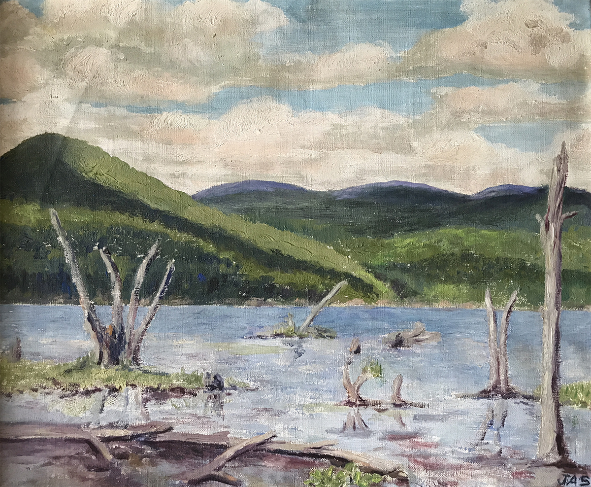 A painting by Julia Allen Streeter from this period shows this “fringe of dead trees” at the western end of the lake. “Cottagers” complained also about the extreme fluctuation of the water level of as much as four or five feet during the summer. As an article in the Fort Plain Standard in 1923 put it: “They say the water line goes up and down as much as the waist line in women’s fashions….[W]hereas a boathouse may be a perfectly good boathouse in the spring, in the summer it could make a good place for storing dynamite or anything else that has to be kept dry.”
It is significant that the establishment of the Canada Lakes Protective Association in 1922 involved a dispute about water level. After the CLPA reached an agreement with the power company, it disbanded until 1952 when residents banded together to acquire the Island from the estate of Cyrus Durey.
1923: Construction begins on new dam:
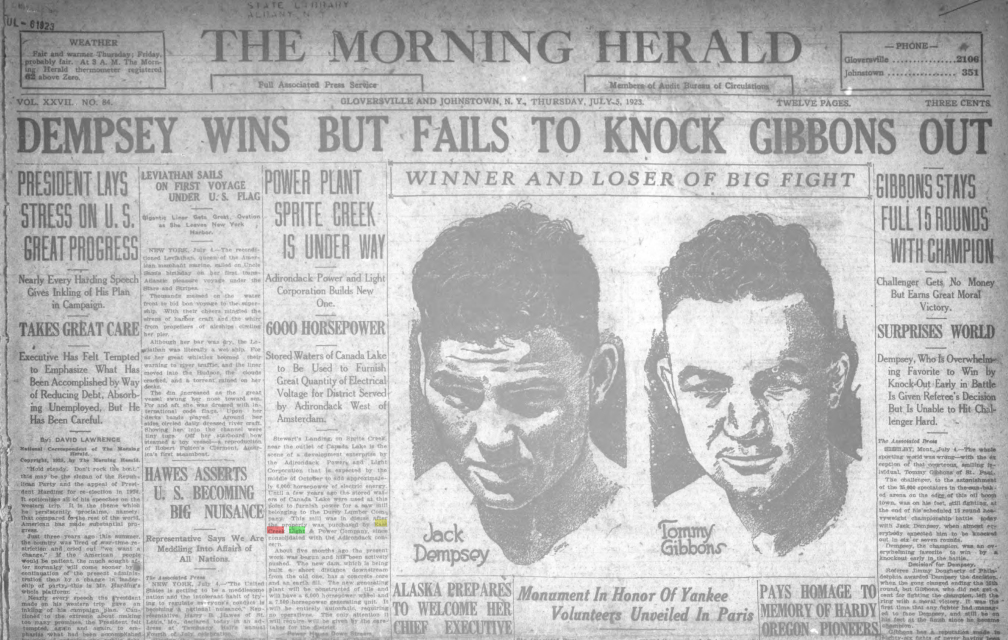
Sharing the front page of the July 5, 1923 edition of the Gloversville Morning Herald with the report of the Jack Dempsey-Tommy Gibbons fight is a story entitled “Power Plant Sprite Creek is Under Way.” In April of 1923, construction work was started on the new dam and was completed in December of that year. The Morning Herald article supplies us with important information. It confirms that the dam was previously run by Durey Lumber Company to power a saw mill. That dam, which was a short distance upstream from the new dam, had fallen into disuse after the property had been purchased by East Creek Light & Power Company which was then consolidated with Adirondack Power & Light Company. We know that Guy Beardslee had acquired land in 1913 at Stewart’s Landing for his East Creek Light & Power Company. Undoubtedly he had plans to build a dam then but as the Morning Herald article indicates that these land “had fallen into disuse.”
![]() The July 23, 1923 edition of Glen Falls’ Post Star included an advertisement by Adirondack Power and Light Corporation touting the construction of the Stewart’s Landing Dam and the Sprite Creek Waterpower plant. Illustrated by a rather fanciful depiction of the power plant and surge tower, the ad states: “Within a few weeks the stored water of Canada Lake, hitherto unused except to turn the wheel of an ancient saw mill will be furnishing six thousand horsepower of electrical energy to the territory served by the Adirondack Power and Light Corporation.” The advertisement promises that acquisition of stock at $100 per share will be “… an investment in which thrift and public spirit join forces to promote the progress and prosperity of a great section of the Empire State.”
The July 23, 1923 edition of Glen Falls’ Post Star included an advertisement by Adirondack Power and Light Corporation touting the construction of the Stewart’s Landing Dam and the Sprite Creek Waterpower plant. Illustrated by a rather fanciful depiction of the power plant and surge tower, the ad states: “Within a few weeks the stored water of Canada Lake, hitherto unused except to turn the wheel of an ancient saw mill will be furnishing six thousand horsepower of electrical energy to the territory served by the Adirondack Power and Light Corporation.” The advertisement promises that acquisition of stock at $100 per share will be “… an investment in which thrift and public spirit join forces to promote the progress and prosperity of a great section of the Empire State.”
The advertisement explicitly states that the new dam and power plant will be the first use of Sprite Creek to produce hydroelectric power.
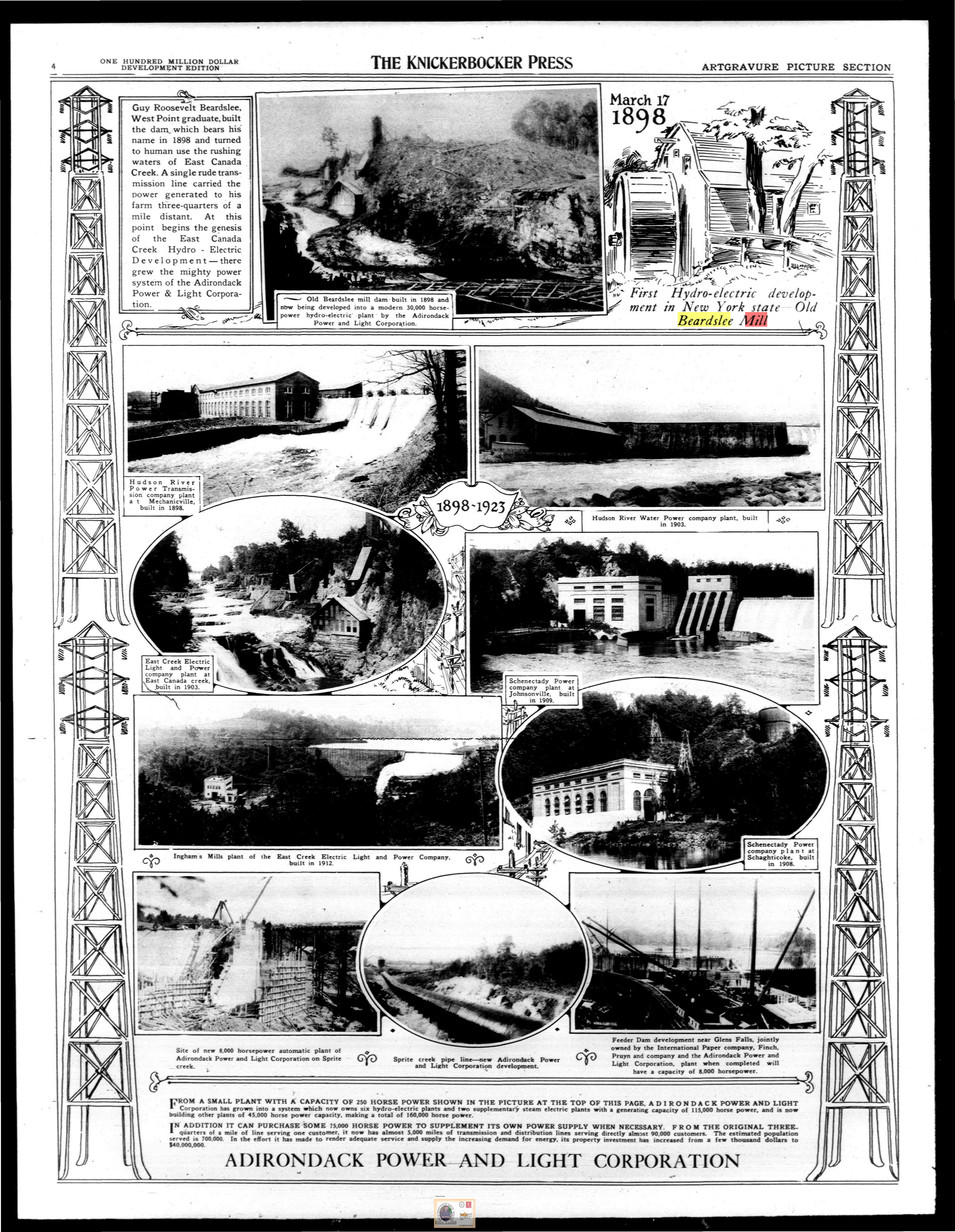
A 1923 advertisement for Adirondack Power and Light Corporation includes a picture of the Sprite Creek Dam under construction and the pipe line leading down to the power plant. The advertisement also includes a picture of the Beardslee Mill and Ingham Mills plants.
![]()
1924 Dam:
![]()
The new dam at Stewart’s Landing and Sprite Creek Power Plant were placed in operation on February 18, 1924. Built by the Adirondack Power and Light Corporation, the dam known also as the Sprite Creek Dam along with the downstream power plant were heralded in trade journals like Power Plant Engineering (August 1, 1923, pp. 802-3) and Electrical World (L. A. Whitsit, “A 7,300-Kva. Automatic Hydro Station-II,” 84, July 19, 1924, pp.111-114). History of the Mohawk Valley: Gateway to the West 1614-1925. edited by Nelson Greene (Chicago, 1925) presents the following description of the 1924 Stewart’s Landing Dam and power plant:
Sprite Creek is the outlet of Canada Lakes and the new concrete dam at Stewarts Landing is the starting point of a wood stave pipe line which winds for nearly four miles to a point where it joins a steel penstock, dipping sharply to the Sprite Creek Power Plant located at an advantageous spot on the stream, and where a net effective head of 370 feet is obtained. This plant enjoys the distinction of being both the first high-powered automatic plant in operation in the State, and the highest head plant and has been a matter of great interest to engineers. The net effective head at Inghams is 127 feet, and the net effective head at Beardslee Falls, when completed, will be 195 feet.
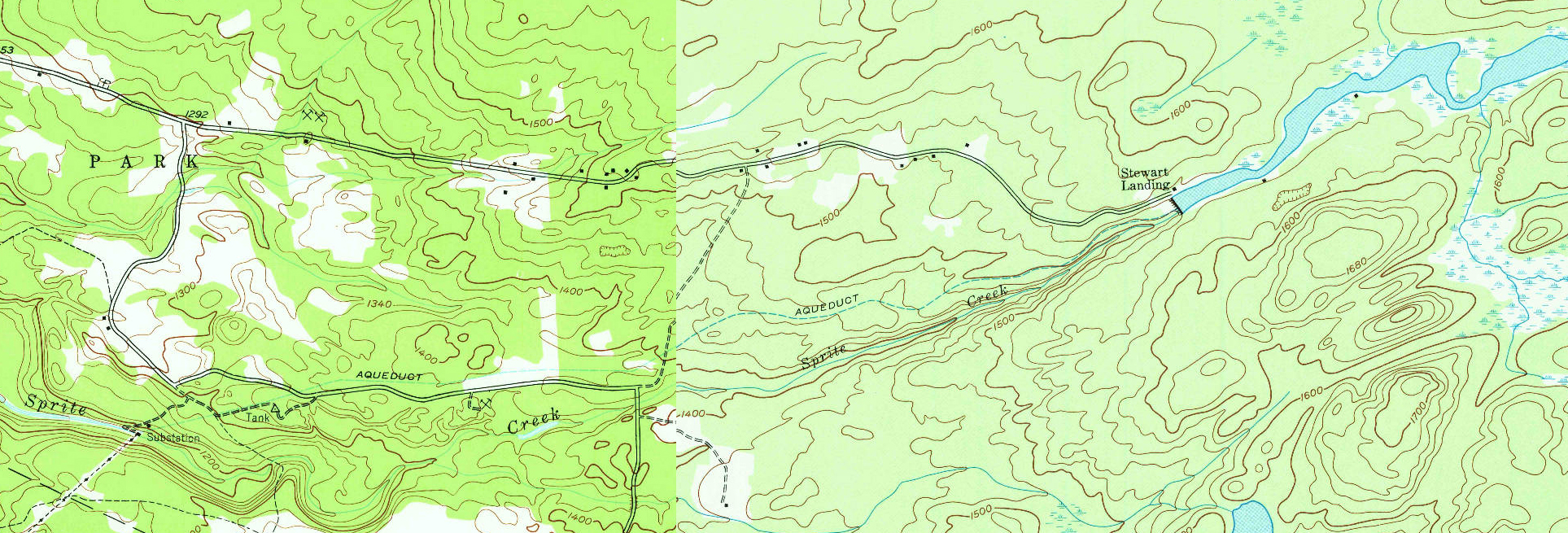
From the Stewart’s Landing Dam, a wood stave pipe line or aqueduct led down four miles to a surge tower. From there a steel pipe or penstock led down to the Sprite Creek Power Plant. The 1945 USGS map shows the aqueduct leading down from Stewart’s Landing to the substation or Sprite Creek Power Plant. The location of the surge tower [tank] is also also marked.
The 7.3 mile transmission line can be seen on the map connecting the power plant to the Ingham’s Mills Dam where an operator could remotely control the power plant. By flipping a switch, the operator could open a water wheel at the Sprite Creek plant to generate power. This made the dam and power plant at the time the largest automatic hydroelectric station and first automatic plant in operation in the State.
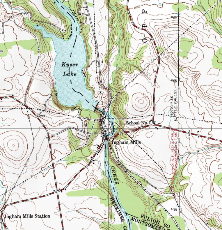
The dotted lines show the power lines converging on the Ingham Mills plant which was planned as the center distribution point for Adirondack Power and Light west of Amsterdam. The line from the Sprite Creek plant can be seen coming down from the northeast.
In likely response to lake property owners’ concerns about flooding, the design of the dam paid attention to ensuring control to avoid damage to lake properties:
In order to be assured of the maximum benefits of reservoir storage in Canada Lake, the discharge capacity of the reservoir dam had to be made such that any sudden increase in water supply from summer rains will not result in damage to private property around the lake and still will permit full utilization of storage capacity. The operation of flashboards will control the variation during the spring flood conditions. In addition to this feature a 9 ft. X 20 ft. Taintor gate is installed which will take care of all normal fluctuations in water level during the summer season (Electrical World)
On April 28, 1924, a deed was recorded for Adirondack Power and Light Corporation in the Fulton County Clerk’s office (Book 174, p. 385) . The power company agrees to respect the “red line” of the Seidel map commissioned by Alfred Dolge and reaffirmed in the 1913 agreement between Durey and Annibal et al.
1931: New York Power & Light Succeeds Adirondack Power and Light:
Deeds record an easement granted to New York Power & Light Corporation dated March 30, 1931. The easement was recorded in the Fulton County Clerk’s Office on June 26, 1931 in Book 207 of deeds at page 136.
1941: Spring Water Level Readings:
As part of the 1947 lawsuit about the properties at the Green Lake Bridge end of what is now Kasson Drive, Albert H. King, a surveyor from Speculator, was asked about the water level records he had taken during the spring of 1941. He recorded daily the levels from the gauge board maintained by the power company on London Bridge. On April 16, the day ice was off the lake, the gauge read 1544.5. The level dropped dramatically after that. On April 29, the lake had dropped to 1542.7. By May 14, the reading was down to 1541.3. This documents the wide range of the water level during this period.
1942: Valentine’s Letter from Paul Bransom to the Douglas Hays Family:
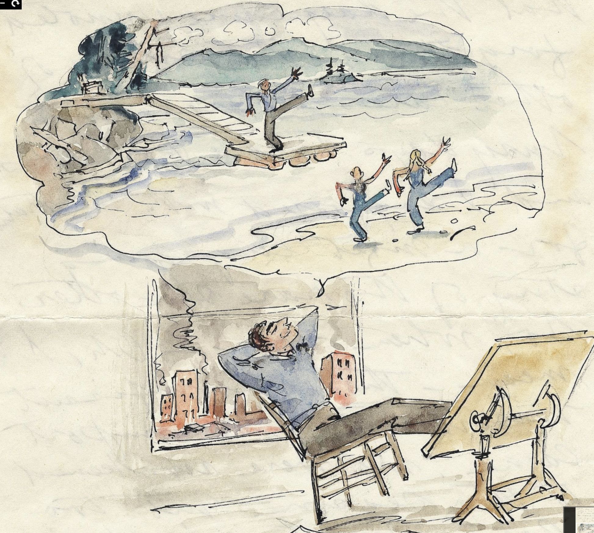
In this delightful sketch, Paul Bransom represents the dramatic drop in water level that occurred during the summer months when the lake was used to generate power. Residents constructed docks like the one shown to adjust to the extreme fluctuations in water level.
1965: Niagara Mohawk decides to abandon the Stewart’s Landing Dam:
The Stewart’s Landing Dam remained in operation producing hydroelectric power until 1960 when it was retired due to plant and equipment obsolescence and it was dismantled. As recounted in an interview with Glenn Voorhees and Willard Harper, the Oregon Mountain Corporation began in 1965 when Harold Voorhees who worked for Niagara Mohawk learned that the power company was selling some of their holdings. Along with his brother Glenn, they put in a bid for approximately 800 acres on Oregon Pond along the Powley Road. Subsequently, they entered into an agreement with Niagara Mohawk to purchase the dam and all the land on both sides of the channel. They laid out building lots. 110 lots were originally surveyed on the north shore. The south shore was left undeveloped because of environmental restrictions. imposed by the Adirondack Park Agency and the 1973 Adirondack Park Land Use and Development plan. Camp owners around Canada Lake were understandably concerned lest the Stewart’s Landing Dam not be maintained by the new owners. In the summer of 1965, Niagara Mohawk agreed to delay the sale of the dam and land to allow the CLPA to work out an agreement with the proposed purchaser.
An article in the September 28, 1965 edition of the Gloversville Leader Herald documents a special meeting of the directors of the Canada Lakes Protective Association. The topic of the meeting was considering the “purchase of a 6 acre tract of land at the outlet of Lily Lake for the construction of a dam to maintain the level of the lakes….” This land had been deeded by Cyrus Durey to the Adirondack Power and Light Corporation for the purpose of a dam. The article speaks of an earlier dam on the spot: “,,,a dirt and rock fill dam at the outlet …given the name of the ‘Indian Dam.’ According to legend, it was reported, the dam was started by Indians in the area.” The plan of the CLPA was to “…construct a 4-foot dam about 1,300 feet long which would maintain the level of the lakes…then [the association] would not have to depend on the Stewart’s Landing 40- foot dam to maintain the water level.” The CLPA never acquired this land. Another resolution at the same meeting was adopted requesting the Niagara Mohawk Corporation to include in any sale agreement of the Stewart’s Landing properties the provision that the Canada Lake water level be maintained: “The resolution asks that from May 15 to Sept. 15 each year, that a maximum of 1545 and a low of 1,541 be maintained and an average of 1543 feet above sea level as the best for the summer season…..”
November, 1965: Agreement between the CLPA and the Oregon Mountain Corporation:
The Oregon Mountain Corporation entered into an agreement with the CLPA in which the Oregon Mountain Corporation agreed to maintain the water level of East Canada, West Canada, and Green Lakes at a winter elevation of a maximum of 1545 feet, significantly this continues the flow line or high water mark of the Dolge and Durey easements. Summer elevations were agreed to be a maximum of 1543.91 feet and a minimum of of 1541. [1543.91 was listed as the crest of the flashboards in the description of the dam in a 1972 CLPA document.] The summer season extended from May 15 to September 15. It was also agreed that in the event the Oregon Mountain Corporation should sell the dam the conveyance would be made subject to all of the terms of the CLPA agreement. It was also agreed that the terms of this agreement be included in the deed from Niagara Mohawk transferring ownership to the Oregon Mountain Corporation.
April 21, 1966: Oregon Mountain Corporation Acquires the Dam:
The deed transferring ownership of the dam from Niagara Mohawk to the Oregon Mountain Corporation stipulates that the latter and its successors will not use the dam for generating power. The deed also incorporates the terms of the CLPA agreement:
Oregon Mountain Corporation agrees to maintain the water level of East Canada, West Canada, and Green Lakes in the Town of Caroga, Fulton County, New York of the winter elevation at a maximum of 1545.00 feet. The summer elevation shall be a maximum of 1543.91 feet and a minimum of 1541.00 feet. The summer season shall be from the period of May 15th to September 15th….
1542.5, the mid point between 1543.91 and 1541, became the target water level.
Fall of 1971: Fulton County takes title to the Dam:
The Oregon Mountain Corporation claimed an inability to pay taxes on the dam. Fulton County took title to the dam for tax arrears.
1972:
To enforce payment of back taxes Fulton County, in the Spring of 1972, refused to close the gates of the dam, resulting in a drop in the water level of the lakes. The County threatened to dismantle the dam. As an emergency measure, the CLPA entered into a temporary agreement with the taxing authorities and the Oregon Mountain Corp. so that the water in the lakes could be restored to its proper level.
CLPA drafts a statement appealing to the State to take over ownership of the dam:
No capital expenditure is needed- the Stewart Landing Dam would be transferred to State ownership for nothing! The only cost would be the satisfaction by the State of a tax lien held by Fulton County in the amount of $25,000. The State would then be responsible for maintenance and supervision of the dam- a relatively minor expense in view of the benefits to a large number of N.Y. State residents.
1973: Acquisition of the Stewart’s Landing Dam by the DEC:
On March 8, there was a meeting of representatives of the CLPA with Glenn H. Harris, the Assembly Majority Whip, along with representatives of the DEC to try to resolve the question of ownership. The CLPA representatives included Jack Ryan, Al White, Harold Egan, and Bernie Caringe. The memorandum from the meeting articulates three alternative solutions:
- Special legislation authorizing the DEC to take over the operation of the dam. “It was …the general opinion of those present while this alternative would be the most desirable from the standpoint of the Canada Lakes Association, it was the solution that offered the least possibility of success.” A CLPA Progress Report sent to the membership includes the assessment: “The [DEC] Commissioner indicated that there were some dozen similar situations throughout the State of New York and the State had no authority nor funds to assume responsibility for and operate any of these various dams. He further stated that he felt it extremely unlikely that any extension of power would be granted to the Department enabling it to assume this function. However, in spite of this almost total rejection, Assemblyman Harris agreed to introduce legislation which would authorize and empower the Department of Environmental Conservation to take over the Dam operation. It is extremely unlikely that this legislation will ever receive the approval of leadership and the Legislature.”
- Special legislation could be introduced to expand the Hudson River-Black River Regulating District to create a subdistrict encompassing the area of Canada Lake and Stewart’s Landing. “Under this alternate proposal, owners within the District would be assessed for the main cost and operation of the Dam. The State being a landowner within the District should provide for paying taxes on its assessment thereby sharing proportionately in the cost for operating the Dam.“
- The third suggestion, according to the memorandum “perhaps the least desirable but the most practical” called for the formation of a new water level district either on a county or bi-town (Caroga and Stratford) level. In the summer of 1972 the CLPA had drafted a proposal for a water district. A tentative agreement had been reached subject of approval by the memberships of the CLPA and Stewart’s Landing Association as well as the approval by Fulton County. The terms of the agreement would call for the district to “levy upon all property surrounding the bodies of water controlled by the dam for the purpose of maintaining and operating the dam, including the payment of taxes to the Town of Stratford….”
At the end of the March 8 meeting, Assemblyman Harris agreed to draft legislation providing for all three options.
On May 22, 1972, the Fulton County Board adopted a resolution calling for the establishment of the Canada Lake Drainage Improvement District “…to operate and maintain the dam and that all expenses for such operation and maintenance shall be charged to the property owners within the suggested Canada Lake Drainage Improvement District. ” This resolution was consistent with the third bill proposed by Assemblyman Harris.
Also on May 22, 1972, Jack Ryan wrote a letter to Governor Rockefeller acknowledging the passing through both houses of the State Legislature of the three bills pertaining to the dam. Ryan appealed to the Governor to sign the bill authorizing the DEC takeover of the dam.
On June 1, Assemblyman Harris announced a $50,000 appropriation included in the state supplemental budget in connection with the proposed state takeover of the dam. These funds were contingent on the Governor approving the state takeover.
On June 11, 1972, Governor Rockefeller signed the legislation calling for the DEC takeover:
Laws of the State of New York, 1973 v. 2 Chapter 619:
The decision for the State to take over ownership of the dam was undoubtedly due to the efforts of Assemblyman Glenn Harris, a Johnstown and Canada Lake resident and majority whip. The DEC in the March 8 meeting had made it clear that it did not want to take on the responsibility. At the annual banquet of the CLPA board of directors, Harris was presented a plaque in appreciation for the assistance he rendered.
The acquisition of the dam by the State marked a critical turning point in the management of the dam. The former president of the Stewart’s Landing Association, George Dieffenbacher, in his history of the dam writes: “The control of the water level and the time schedule for raising and lowering has been a cooperative agreement between the Stewart’s Landing Association, the Canada Lake Protective Association and the Department of Environmental Conservation. This continued cooperation is essential to maintain the lakes for everyone to enjoy.” Much of the later history of the dam involves the working out of this cooperative arrangement.
This also marked a critical change in the approach to water level. Before this point, water level was approached as a range from high to low. In Oregon Mountain’s 1965 agreement with the CLPA the summer level is defined as a range between 1541 and 1543.91. Agreements with the Durey Land and Lumber Company and then the power companies written into deeds also specify the range of water level. The following agreement is typical:
Grants to Durey Land and Lumber Company, its successors and assigns, the right to erect and maintain a dam over and across the ***outlets of *** (Auskerada or Canada Lake, West Canada Lake, and Green Lake), and the right to raise the water in said lakes as necessitated by said dam up to the high water mark on the property owned by each respectively as shown by a red mark, or line, upon a map of cottage lots filed in the County Clerk’s Office by the Caroga Lumber Co., made by J.W. Miller, C.E., from the maps and survey made by one, Seidl for Alfred Dolge and Caroga Lumber Co. and to maintain the water at said height and draw down the same without any claim or claims or damages against Durey Land and Lumber Co. by us or any of us. It being agreed by said Durey Land and Lumber Co. that the water of said lake shall be kept at least one foot higher than the present low water mark.
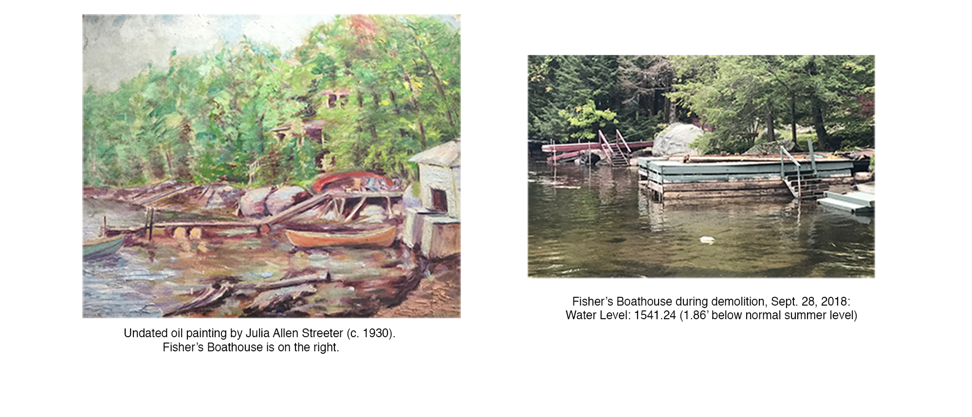
This range of levels was critical when the dam was used to power the sawmill or the hydroelectric plant. Both industries wanted high water in the spring to insure an adequate flow throughout the summer. Residents could expect this range. Many docks from this period were floating so that they could adjust to the changing levels. For older residents, there are memories of beaches along the north end of Kasson Drive and around the lake. A painting by Julia Allen Streeter from about 1930 documents the dramatic drop in the water level, especially when it is compared to a photo of the same view taken in September, 2018 when the Lake was 1.81′ below today’s accepted summer level of 1543.1′.
Since the acquisition of the dam by the DEC, water level has been approached as a target number. The first recorded level 1542.5 was reached by splitting the difference between the high and low of the earlier range, 1543.91-1541. Approaching water level as a target number has led to the ongoing debate as to what that number should be, and also the expectation of a more consistent level. Residents have become less tolerant of the range of levels that were accepted before the DEC acquisition. This is reflected today by the decision of owners to set their docks at a fixed level.
1975, Water Level Raised to 1542.83 from 1542.5:
In a letter dated July 24, 1975, George Dieffenbacher, the President of the Stewart’s Landing Association, requested Thomas Shearer of the DEC to increase the level to 1542.85 from 1542.5 feet. Doug Leaf, the CLPA President, in a letter to Thomas Shearer, informed him of the CLPA’s request “…that the state hold the median level of the lake at 1542.83 above mean sea level. This is within the deed terms and was voted on at our meeting as being the best possible compromise.” In a letter dated July 28, 1975 to Doug Leaf, Thomas Shearer informs the CLPA of his request to have Bruce Busch, Stewart’s Landing Dam operator, maintain the water level at 1542.83′
A document dated July 1, 1975 in the DEC files records the level of the concrete spillway as 1542.41.’ The flashboards are said to be 9″ which means they would be 1543.16 feet. Does this height explain why 1543.1′ would become today’s accepted water level?
1976:
In September, “Stuart’s [sic] Landing” property owners submitted a petition to Thomas Shearer requesting the installation of “an automatic level control system at the dam. This would insure efficient, day-to-day regulation of water level avoiding the 6″ – 9″ variations which often occur now.”
DEC files have a document dated October 18, 1976 which presents their evaluation of automatic level control gates. DEC engineers determine they would be too expensive and not suitable. Setting flashboards is considered to be the more preferred means for controlling water level.
In October, George Dieffenbacher sent a letter to Bernie Caringe, the CLPA President, with five requests (see 1976-78 documents):
- Changing the date for raising the water level from May 15 to May 22
- Changing the date for lowering the water level from October 1 to December 1.
- Curtailing ice fishing on Lily Lake.
- Clearing major obstruction to water flow from Canada Lake to Stewart’s Landing.
- Raising the winter water level in the channel.
The reasons for these requests were to improve fishing, allow longer use of boats in the fall, and provide more time in the spring for waterfront work.
In November, Dieffenbacher sent a letter to Thomas Shearer making the above requests (see 1976-78 documents). He repeated his request for an electronic water level control which would “be more economical for the state to maintain the level of the water at 1542.83′.”
1977:
A meeting of members of the Stewart’s Landing Association, CLPA, and the DEC was held in Northville on May 16, 1977 to discuss the operation of the Stewart’s Landing dam (see 1976-78 documents). The proposed schedule was to close the gates annually on May 15 with the goal of raising the water level to 1542.83, the agreed summer level. On October 15, the level would be dropped three feet to 1539.83′ and kept at that level until December 1 when the level would be dropped to the winter level of 1536.41′. Final acceptance of the proposal waited for approval by the two associations.
The Stewart’s Landing proposal for an electronic water level control system was discussed. Shearer again reported that DEC engineers determined that system “may not effect desirable control and installation probably too expensive.” George Dieffenbacher introduced information that such a device might cost about $15,000 and “can be installed with a minimum of difficulty and work accurately.” Shearer agreed to explore the option further.
A letter dated June 6, 1977 from George Dieffenbacher to Thomas Shearer records the Stewart’s Landing Association’s approval of the proposed water level schedule. A July 26 letter from Bernie Caringe reports the CLPA’s approval of the proposal.
1978:
On May 16, the DEC conducted an inspection of Canada Lake (see 1976-78 documents). Concerns were expressed about sewage systems being compromised and erosion occurring due to the higher water level.
On June 6, a meeting composed of representatives from the CLPA, SLA, and the DEC was held at Northville (see 1976-78 documents). The CLPA was represented by John Kasson, Mert Lesser, and Bill Fielding. Canada Lake residents Barbara McMartin, Bruce Berlind, and Jim McClelland also attended. The central issue was a review of the proposed future water level operating schedule. The most significant change from the previous schedule was that instead of waiting until May 15, the dam would be closed promptly after the ice is off the lakes. 1542.83′ as summer level, drawing down the lake beginning on October 15 to 1539.83, and the final drawdown on December 1 to 1536.41′ that were a part of the 1977 agreement were continued.
It was suggested that the height of the flashboards which were recorded at 1543.16 be reduced to 1542.83′, consistent with the summer level. After discussion it was decided to keep the flashboards at 1543.16. This height of 1543.16 for the flashboards perhaps explains the later decision to later raise the water level to 1543.1. A part of the discussion was the necessity to draw the water level down in the Fall. A number of attendees advocated for maintaining a consistent water level throughout the year. This would minimize the loss of spawned fish eggs. The DEC dam operators countered arguing “the water must be dropped to 1536.41 feet by December 1, to prevent dam damage.”
In a letter dated July 6, Thomas Shearer informed Dennis DeLorier, the CLPA president, of the “Proposed Water Level Operating Schedule” (see 1976-78 documents):
“The gates at Stewart’s Landing Dam will be closed annually immediately when ice is off the subject lakes promptly (within one week) raising the water level to 1542.83 feet. This water level will be maintained until October 1. On October 1 the water level will be promptly (one week) dropped to 1540.83 feet and will remain at this level until about December 1. On December 1 the water level will be dropped to and maintained at the winter level of 1536.41 feet. Periodic dam maintenance by DEC is required and will be accomplished when necessary between May 20-June 25 and / or Labor Day-October 25. During the period of dam maintenance the water level will not be dropped below 1541.00 feet.
In September 28 letters to John Kasson and Mert Lesser, Thomas Shearer sent copies of the water level operating schedule and reports: “As you know, our water level objective between ice out in the spring to October 1 is 1542.82 feet. We have been monitoring the 1977 and 1978 water level readings as influenced by our dam operating procedures. We plan to adjust our procedures, including the modification of the height of the splash boards as may be necessary to assist us in maintaining the objective level.” The schedule that Shearer submitted is consistent with the one he sent to Dennis DeLorier in July. The schedule concludes with the following statement: “The presidents of either association acting under authority of their membership may request the Department to consider changes in the above schedule.”
In a letter dated October 3, 1978, Thomas Shearer notified the associations of repairs on the spillway and the necessity of lowering the water level: “It will be necessary to lower the water level to one foot below the bottom of the tainter gate (1535.41 feet) in order to complete the concrete work and install a timber sill prior to freezing weather….”:
We wish to advise you that the water level at the dam will be lowered to 1535.41 feet beginning October 16 and reaching this level by October 19. For your information the 1535.41 feet level is 7.42 feet below the agreed summer level, 5.42 feet below the agreed October 1-December 1 level, and 1.00 foot below the agreed winter level. As you know drawdown will not affect water level below 1540 feet in the upper lakes due to channel obstructions near Lot 75, Old Stone Dam.
Lot 75 of the Stewart’s Landing Development is 1168 Stewart’s Landing Road.
DEC Files list a directive dated December 1, 1978 from the DEC Regional Operations Supervisor to reduce the flashboard height from 9″ to 6 1/2″. This after a review of recorded water levels were averaging somewhat high. A note in the DEC files dated April 27, 1979 records that the flashboard had been cut and lowered 2 1/2″ to 6 1/2″.
1981
July 18, 1981: Stewart’s Landing Association sent a proposal to DEC requesting that the water level stay at what they refer to as “natural level” until December 1. Their rationale was to provide a resting and feeding place for migrating birds.
September 17, 1981: Howard Fiedler, President of the CLPA, wrote a letter to Thomas Monroe of the DEC requesting the continuation of the 1978 schedule with 1542.8 as the summer level. The lake would be drawn down to 1540.8 on October 1, and drawn down to winter level of 1536.4 December 1. The intermediate drawdown is to accommodate dock and boathouse maintenance.
October 8, 1981: Thomas Monroe, Regional Director- Region 5, responded to CLPA request to continue summer level at 1542.8 and the winter level at 1536.4 with an October 1 drop to 1540.8.
April 28, 1983:
From the DEC Files, simultaneous readings at the dam and at Green Lake indicate a 10.8-12 in difference in elevation. There was no record on how this was accomplished. A 4-7″ differential was accepted by the Stewart’s Landing Association. The discrepancy is likely explained by the head of water flowing from the lakes to the dam. It would increase in a rainstorm, and likely decrease during dryer periods.
Sprite Creek Power Project Proposal:
An article in the Schenectady Gazette dated August 30, 1983 announced that Raymond Gload, an electrical enigineer, sought the support of property owners along Sprite Creek for a proposed hydroelectric power project. Tim Mitchell, CLPA president, wrote letters to legislators and to Gload questioning the project and its impact on the CLPA community. Dieffenbacher’s history of Stewart’s Landing Dam records that the proposal was not deemed to be economically feasible. Also the 1965 Niagara Mohawk Deed with Oregon Mountain Corporation specifically stipulated that the dam could not be used in the generation of power.
1985: CLPA and SLA proposed changes:
In a letter to the Stewart’s Landing Association, Emily Langworthy, CLPA President, reported on a motion made at the CLPA’s annual meeting: “to leave the water level up until November 15, weather permitting, on a rotating schedule.” Langworthy proposed a “draw down to the lowest scheduled level at the beginning of October one year out of every four or five.”
DEC Files: Henry Eifert, presented a Stewart’s Landing proposal: Gates should be closed at ice-out; 1542.83′ is accepted as the summer level; level should be controlled by the natural flow over the dam; periodic opening and closing of the gates should occur only in extreme emergencies; 1542.83′ should be maintained until November 15; final drawdown on November 15 to 1536.41.’ Intermediate drawdown every four years (leap years) when level is drawn down to 1539.81′ on October 15 and the final drawdown occurs on December 1.
Most of Eifert’s proposed schedule is consistent with the September 13, 1978 plan. The major difference is the pushing back of the annual drawdown to November 15 from October 1. The Langworthy and Eifert statements mark the first appearance in the records to the Leap Year drawdown. This was probably a compromise to allow for the later annual drawdown. Significantly, Eifert’s schedule continues to keep the summer level at 1542.83′.
1986: Revised Schedule:
February 19, 1986: General Meeting and revised Water Level Control Schedule:
In a letter dated July 16, 1986 to Henry Eifert and Emily Langworthy, William White of the DEC submitted a “proposed water level regime.” This revised schedule incorporated a number of Henry Eifert’s suggestions. The most significant difference is the identification of 1543.1 feet as the summer water level. As the DEC Files acknowledge “background leading to change not recorded to file.” While Eifert accepted 1542.83′ as the summer level the previous year, there is no explanation in the record for the change to 1543.1.’ A handwritten draft of the water level agreement perhaps written by Emily Langworthy mentioned that 1543.1′ would “be maintained by the installation of adequate splashboard on the top of the dam spillway.” This decision is perhaps made to allow the level to be controlled by the natural flow over the dam including the flashboards. The schedule makes it clear that the “gates will be opened in cases of extreme emergency.” The written draft states the “opening & subsequent closing of the gates will be used only in extreme emergencies. Normally expected summer rain showers will not be considered an emergency.”
Like Eifert’s 1985 proposal, the revised proposal calls for the November 15 drawdown to 1536.41, the bottom of the tainter gate. Presumably the tainter gate would be left open while the sluice gate would remain closed as is the current practice.
The revised schedule also incorporated Eifert’s proposal for a leap year drawdown: “Every four years, beginning in 1988, the gates will be opened for an intermediate drawdown in the fall on October 15. Water will be lowered to the 1539.83 level to facilitate dock and shorefront maintenance. On November 15 the water level will be lowered to 1536.41, unless weather conditions mandate an earlier lowering.”
An aspect of this revised schedule is the DEC appeared to assert much more control of the dam: 1) “Any request to deviate from the proposed water level control schedule must be made in writing to the Regional Supervisor of Operations…”; 2) “The Department of Environmental Conservation retains the right to periodically adjust water levels for maintenance of the Stewart’s Landing Dam…”; 3) “The Department of Environmental Conservation retains the right to draw the water levels down whenever, in their judgement, an emergency conditions exists….” This is in contrast to the 1977 Agreement which “…was confirmed by respective Association meetings and letters to Thomas D. Shearer….”
December 30, 1987: Bruce Busch, Dam Operator, Retires:
DEC Files: The DEC did not replace Busch so that there has not been a Dam Operator since.
November, 1988: Engineering Evaluation:
DEC Files: It is determined the whole upstream side of dam is pitted and in need of resurfacing.
November, 1989: Dam repairs begin:
DEC Files: refacing of dam to be carried out during the winter months. Anticipate that the gates will be closed by June 1, 1990.
Summer of 1990: Completion of Dam Repairs Delayed:
DEC Files : the gates were closed toward the end of June. There was little rain that summer so that the water level was well below normal levels for most of the summer.
2003: Lawsuit
On April 23, Canada Lake residents, David Jung, John Robinson, and Jim Hays filed a suit against the Department of Environmental Conservation. They argued that the DEC “in an arbitrary, capricious and unlawful manner [failed to maintain] the Canada Lake summer water level at 1542.87 feet above sea level as reflected in the Water Level Agreement [the 1978 agreement which called for the summer level to be maintained at 1542.82] or, alternatively, the level of 1543.1 above sea level as reflected in the Amended Water Level [the 1986 agreement].” The 1986 agreement is referred to as “purported amendment to the Water Level Agreement (p, 2, paragraph 9). Page 3, paragraph 10 states that “the Amended Water Level Agreement was not agreed to by all the parties and interests upon whose behalf the Water Level Agreement was initially made and thus may be null and void.” There is merit to this claim. While the documents pertaining to the earlier agreements include the approval of the different associations, there is no evidence of an approval process for this 1986 Agreement. 1543.1 has become the accepted summer water level, but there is no evidence that it was ever formally agreed upon.
The suit also claimed (p. 3, paragraph 11) that the gauge on Green Lake Bridge, used to measure the water level, was in error. Modern GPS instrumentation, the plaintiffs asserted, demonstrates that the dam and gauge may be eight inches higher than was claimed when the dam was constructed in 1923-24. Scott Orr, an official surveyor for the DEC, in a letter dated January 7, 2003, showed that the gauge at the Green Lake Bridge, is 1543.77 feet above sea level instead of 1543.1 feet. Thus the gauge is off by .67 feet.
Independent of the trial, David Doyle of NOAA in an email dated October 21, 2004 to Tim Mitchell, demonstrated that this discrepancy can be explained by the different vertical datum used in measuring height when the dam was built than today. The datum used when the dam was built was so-called 1912 Fourth General Adjustment while the later measurements would have been based on NGVD 29 (National Geodetic Vertical Datum of 1929). While there is no bench mark associated directly with Stewart’s Landing to compare, Doyle did find four benchmarks in the region that had information for both the 1912 Fourth General Adjustment and NGVD 29. The average height difference from 1912 to NGVD 29 is +0.82 feet. So the discrepancy in height can be explained by different datums used rather than faulty measurements. 1543.1 of the 1912 Fourth General Adjustment is likely equivalent to 1543.77 of NGVD 29.
Justice Bernard J. Malone issued on June 16, 2003 a ruling against the plaintiffs. At the core of the Judge’s ruling was that the deed conveying the dam to the DEC granted the DEC the “discretion to maintain the water levels between 1,541 feet and 1543.91 feet above sea level.” The judge also ruled that the 1978 and 1986 Schedules are not contracts. He observed that the 1986 Schedule which superseded the 1978 Schedule was not even signed, a necessary element of a binding contract. Even the two Schedules “reserved to DEC the right to change the water levels at the Dam.”
Conclusion or another Goldilocks Story:
In his letter dated July 16, 1986 to the presidents of the CLPA and SLA announcing “proposed water level regime”, William White, Senior Aquatic Biologist for the DEC, wrote:
As we are all aware, water level control is not an exact science. Every action has an equal reaction, and the proposed schedule is an attempt to blend many expressed concerns into a regime which will give partial satisfaction to lake residents, water level managers, and the natural resources of the area.
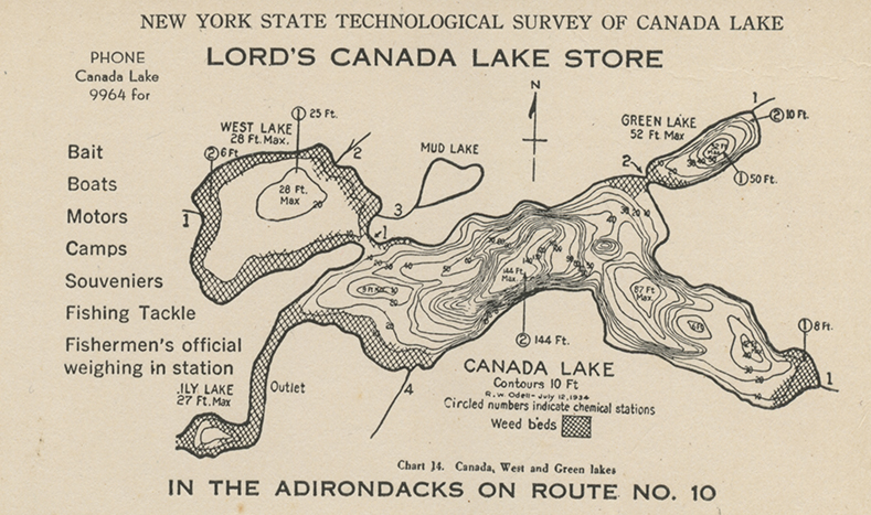
This makes clear that the management of water level necessitates compromises between competing interests. The higher water levels that have opened up new lands for development especially along the channel have meant the loss of wetlands and natural shorelines around portions of the lakes. A 1934 Technological Survey of Canada Lake documents the existence of weed beds at the western portion of the lake, around West Lake, and into Lily Lake:
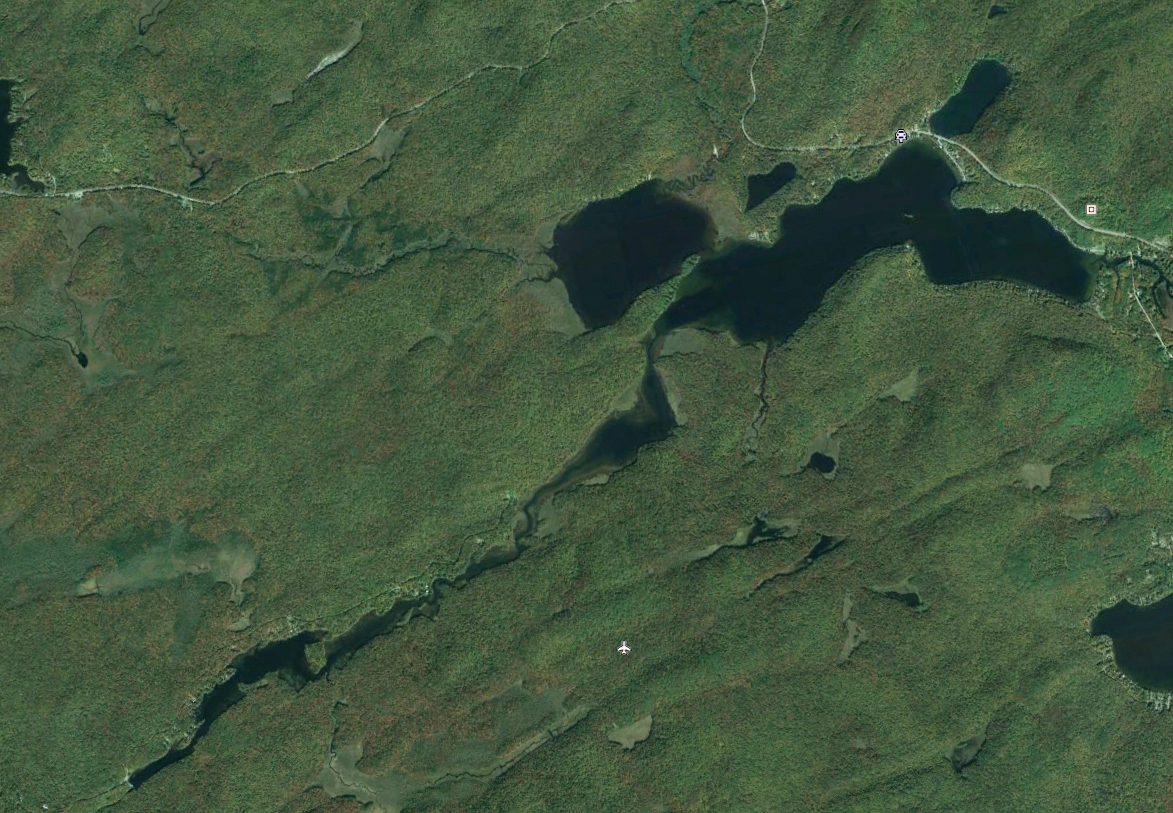
A Google Earth view of the Lake shows these now submerged weed beds:
These wetlands play an important role in the ecosystem: habitat for fish and wildlife, protection of water quality, erosion prevention, and flood control. The wetlands filter and collect sediment from runoff and act as a sponge absorbing excess water during a flood.
The higher water levels have submerged the natural beaches that used to ring the lake. The beaches at Sand Point and Point Breeze are now submerged when the lake is at today’s accepted level.
Beaches play an important role in protecting the shoreline from erosion by dissipating the power of waves.  Where there was a natural beach around the island as seen in the early postcard, with today’s higher water level riprap had to be added to protect the shoreline from further erosion. Some property owners around the lake have had to add riprap to protect their shorelines from erosion.
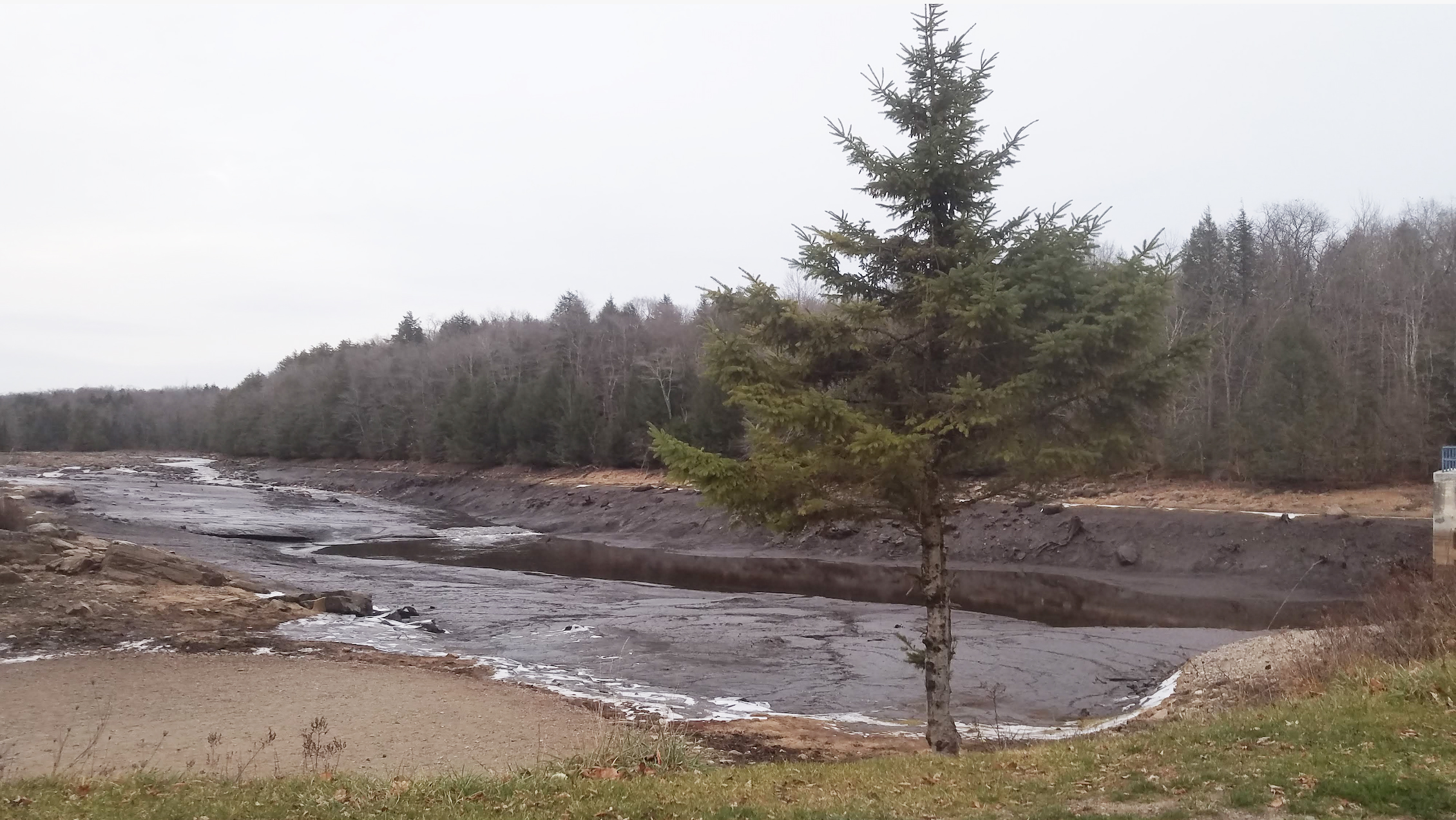
The pictures above taken in October and November of 2020 starkly demonstrate how essential the dam has been for developing the properties along the channel. The first picture was taken on October 8, 2020 when the water level at the Green Lake Bridge was at the accepted summer level of 1543.1. The second picture was taken on November 25, 2020 when the water level was drawn down below the tainter gate to facilitate repairs. Without the dam the channel would be a meandering stream bordered by weed beds. The development of the channel properties was only feasible when the water level was relatively stabilized at a higher level with the Oregon Mountain Company acquisition of the dam. When the dam was being used for hydroelectric power, there was no development along the channel. The wide range of water level necessitated to maintain an adequate flow to power the hydroelectric plant made the land unattractive as water front properties. Canoeing down the channel before the mid 1960s one would come upon only a few isolated hunting camps.
The DEC which has controlled the dam since 1973 has had to balance competing concerns. This has become more of a challenge due to climate change. In recent years we have had more extreme storms which have led to major flooding. The DEC has had to take into consideration both upstream and downstream conditions during these floods.
A challenge for the DEC is the nature of the watershed. The fairly large catchment area needs to be drained through a narrow channel. This has been likened to trying to drain a bathtub with a straw. 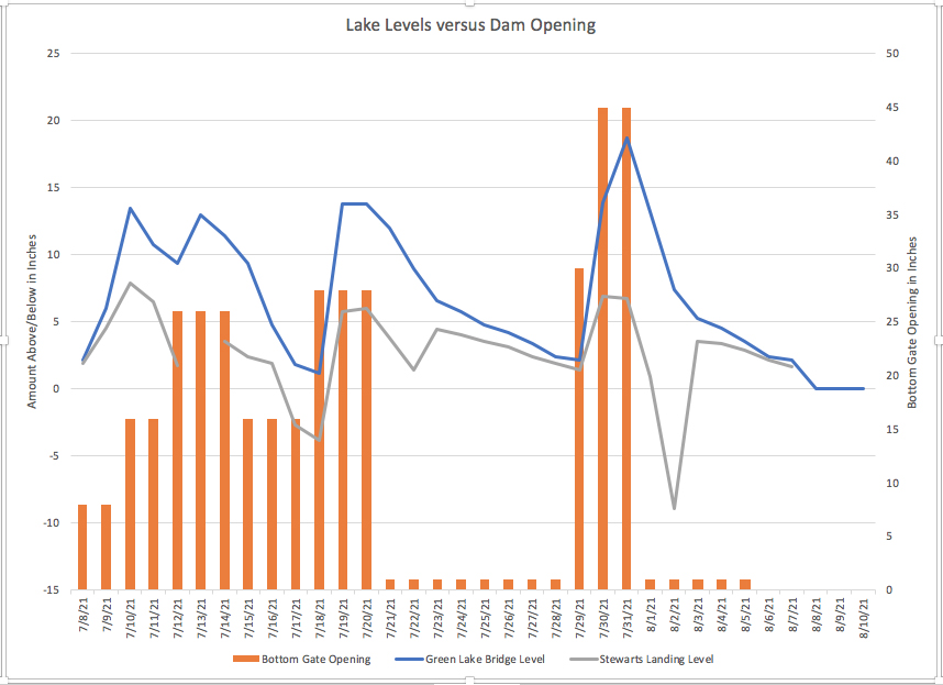 The accompanying chart documents storms during July 2021, and shows the disparity between the level on lake at the Green Lake Bridge and the level at the dam in response to adjustments of the sluice or lower gate of the dam. While the lake can be well above the accepted level, boats near the dam can be mired in mud.
The climate instability has meant that we have had extended dry spells. While lake and channel residents would like to close the dam as much as possible to maintain the water level, the DEC needs to insure an adequate flow to sustain the ecology downstream especially for fish habitat. As suggested by William White’s statement that began this section, the competing concerns have meant that decisions that are made “give partial satisfaction to lake residents, water level managers, and the natural resources of the area.” One thing is certain, debates over the water level will continue into the future.
A Picture Album
Drone Views of the Channel:
Randy Fredlund has created the following drone views of parts of the channel leading to Stewart’s Landing. These composite photos are intended to document the channel, and should be used with caution. The photographs record the water level on the days that they were taken. The level can change dramatically due to the channel’s topography. Hazards can change relative to the water level. Obstacles can also move. The CLCA should not be held liable or responsible if these photographs are used for navigational purposes
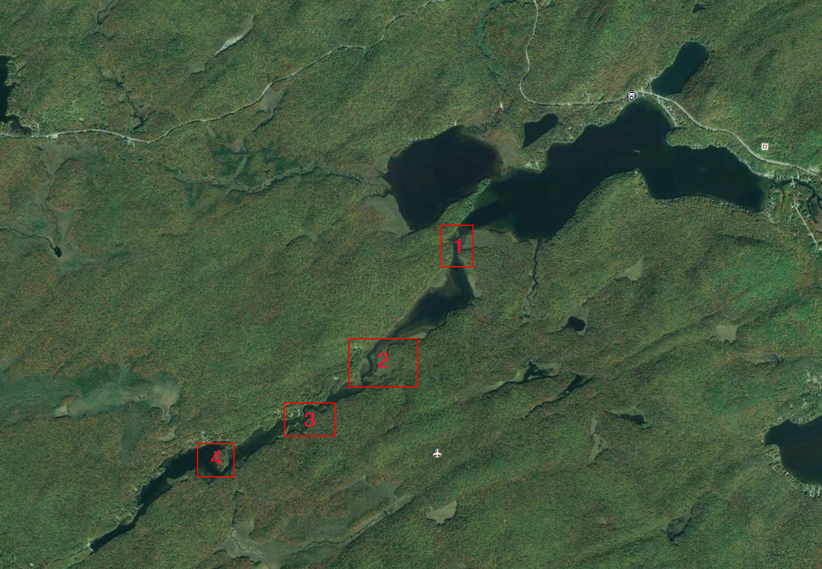
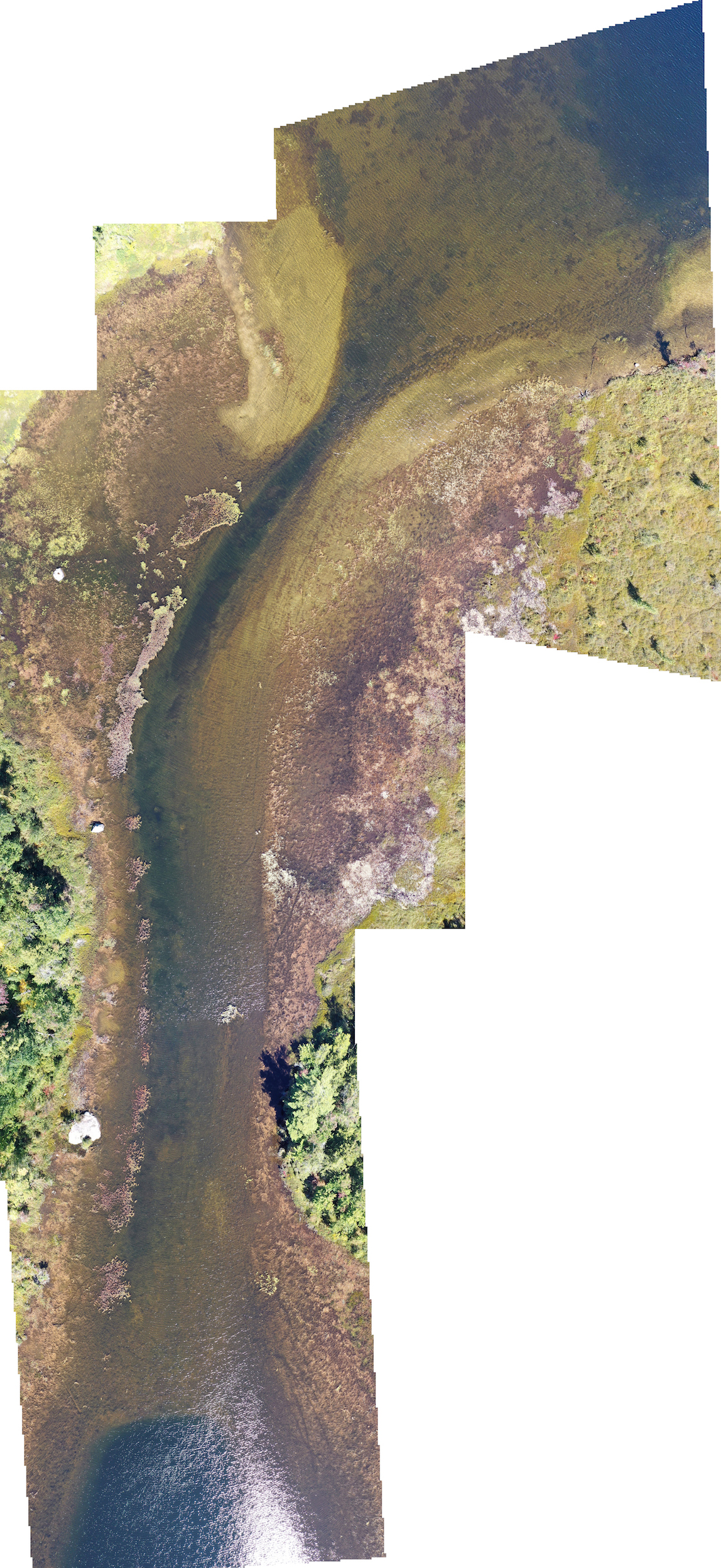
- Entrance to Lily Lake from Canada Lake; Photograph taken from 400′ on September 18, 2020: Water level: 1542.86 or 2.88″ low
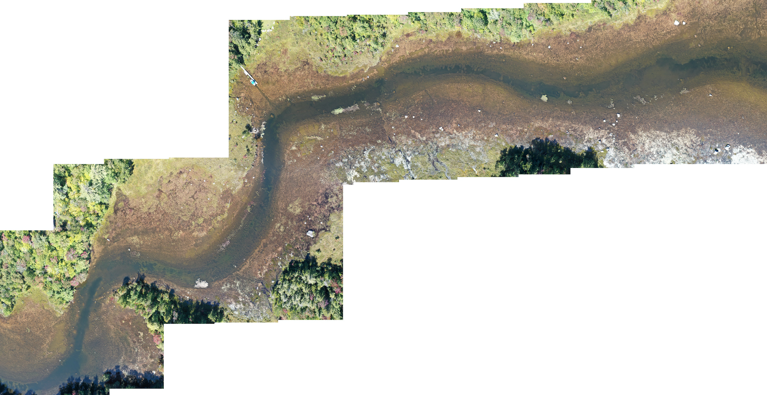
2. Lily Lake to Rock Dam: Photograph taken from 400′ on September 18, 2020; Water level: 1542.86 or 2.88″ low
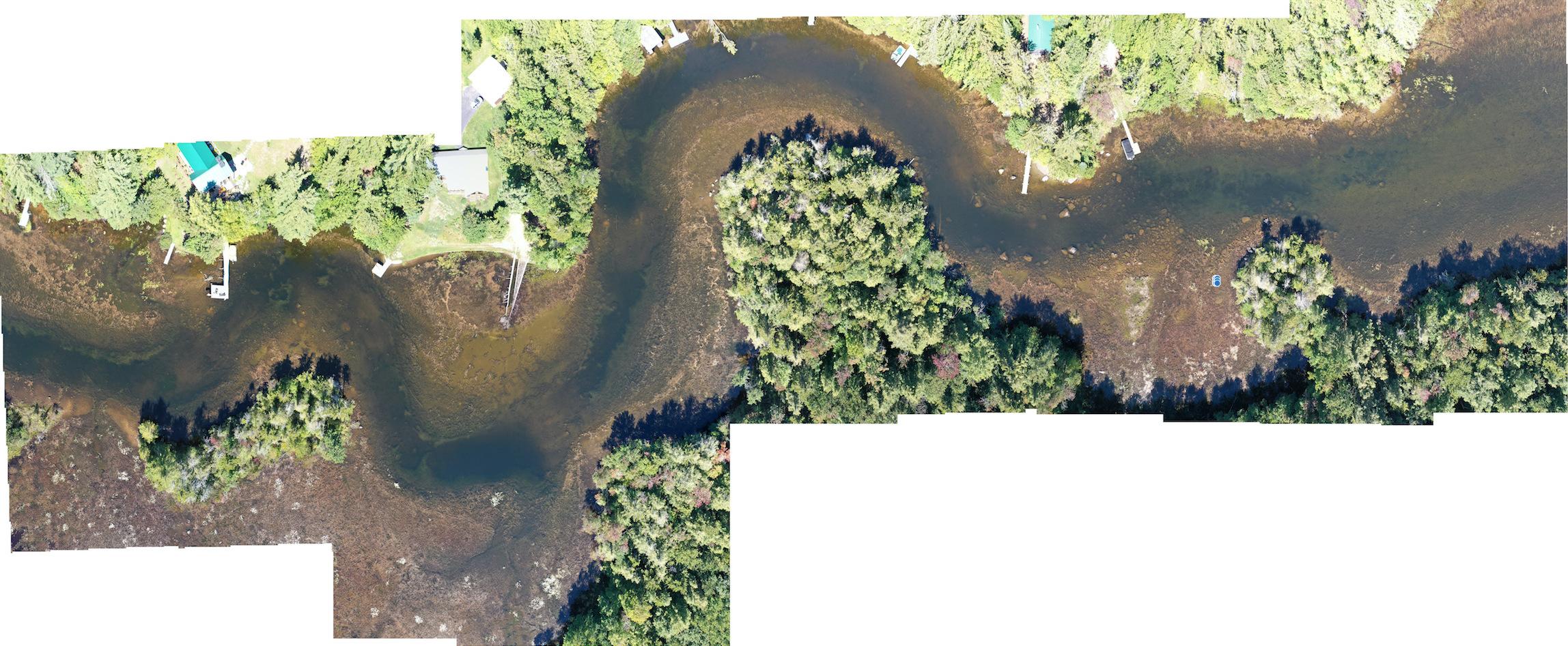
3. W Channel: Photograph taken from 400′ on September 11, 2020: Water Level: 1542.92 or 2.16″ low
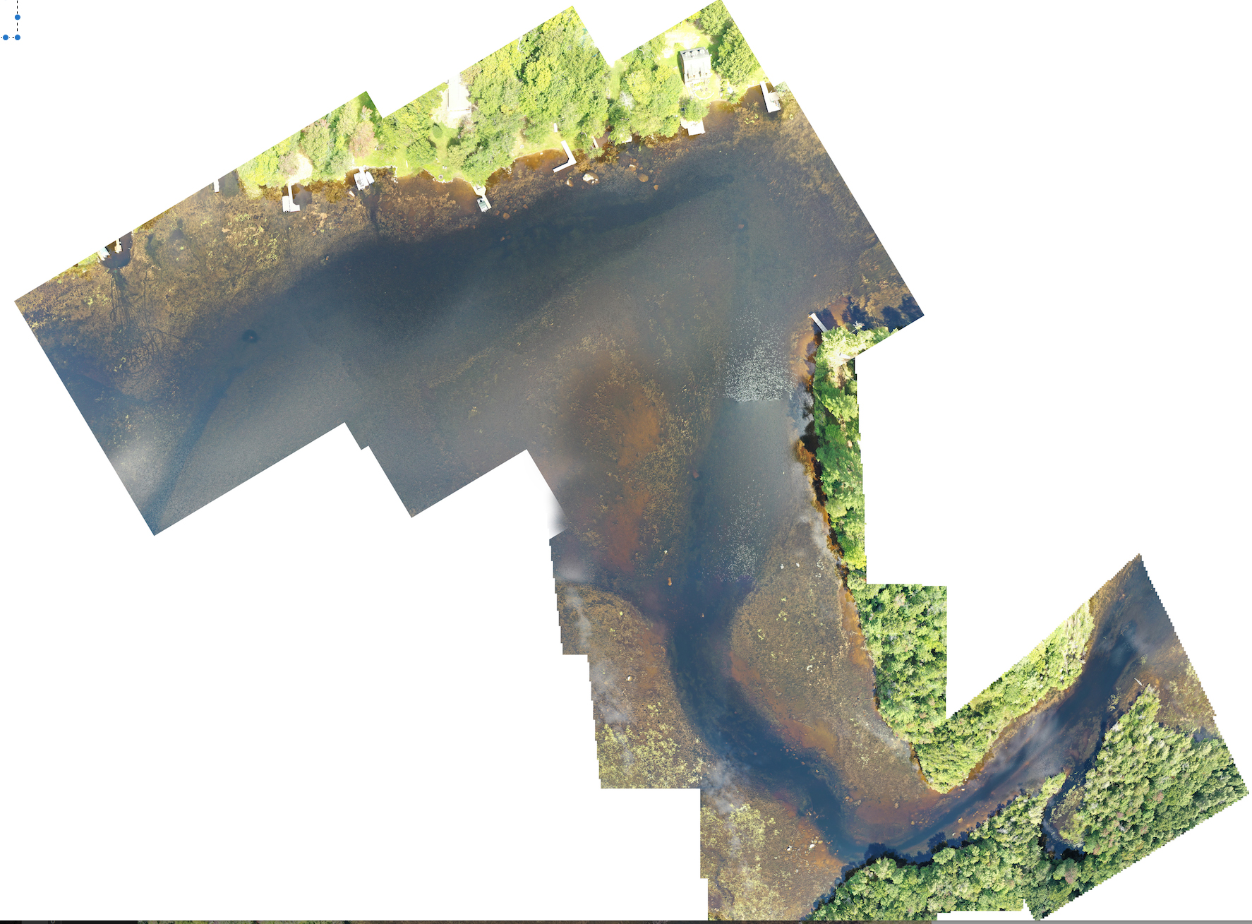
4. Pine Island: Photograph taken from 400′ on September 3, 2020. Water level: 1543.02 or 3/4″ low.
Views of the Dam:
June 28, 2021:
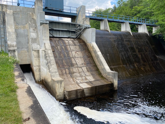 The lower, sluice gate is open 1″; the upper, tainter gate is closed with no leaking; no water running over the spillway. The water level at the Green Lake Bridge was 1543.02′, or 1″ below summer level.
July 12, 2020:
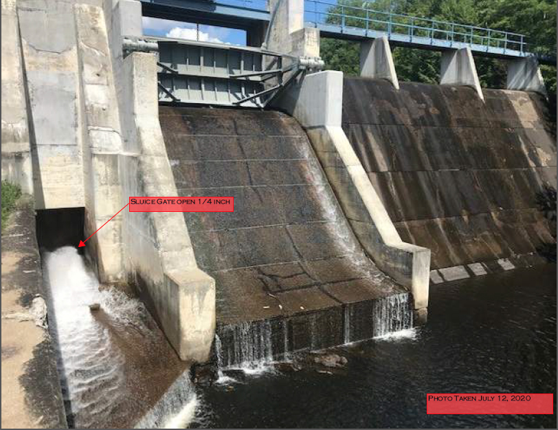
The lower, sluice gate is open 1/4″; tainter gate is leaking; spillway is dry. Water level at Green Lake Bridge was 1542.56′, 6 /1/2″ below summer level.
![]()
Sprite Creek on July 12, 2020 showing minimal flow downstream.
October 30, 2019:
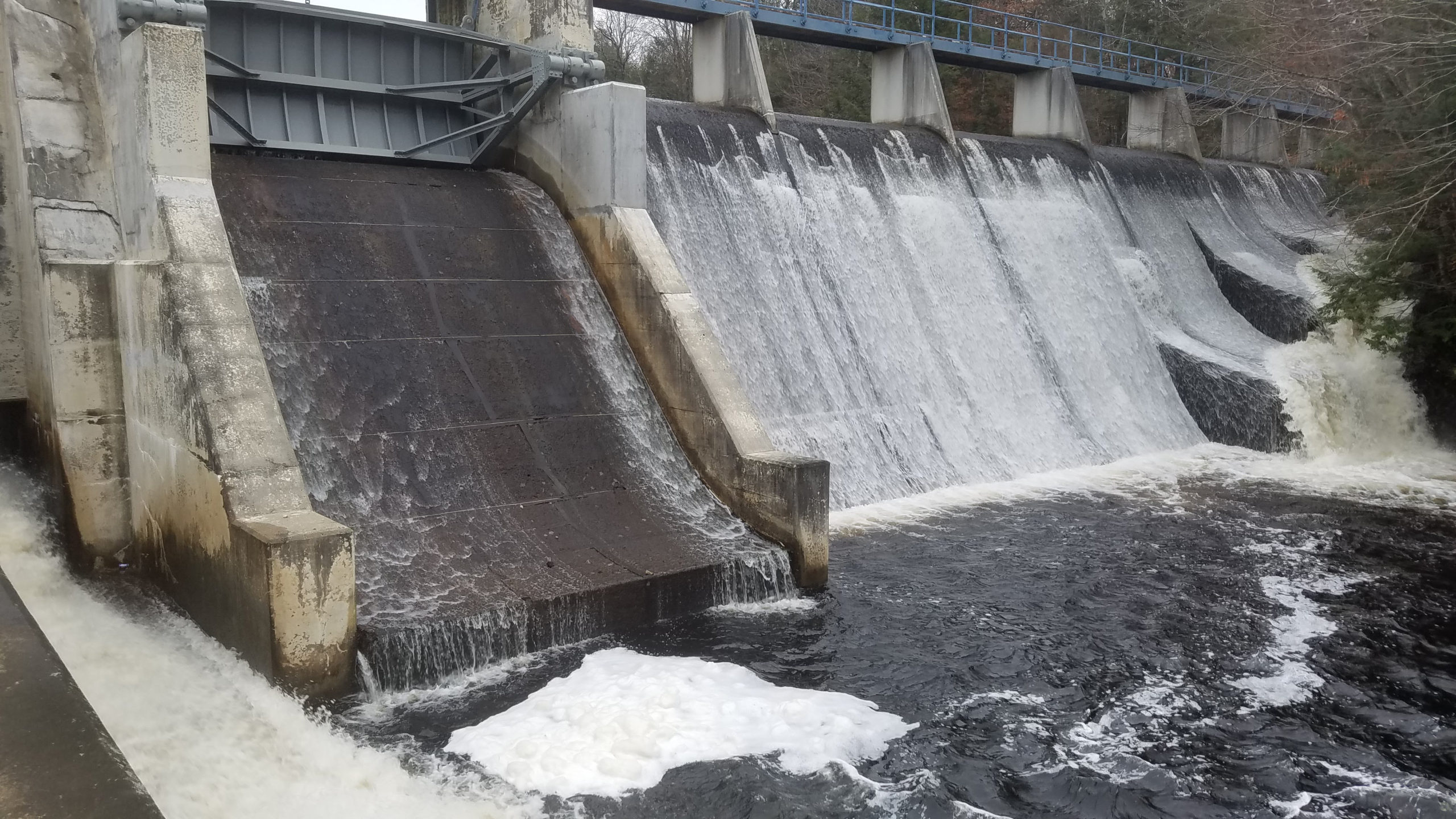
The lower, sluice gate is open 6″; the upper, tainter gate is closed with leaking; water running over the spillway. The water level at Green Lake Bridge was 1543.36, 3″ above summer level.
October 25, 2020
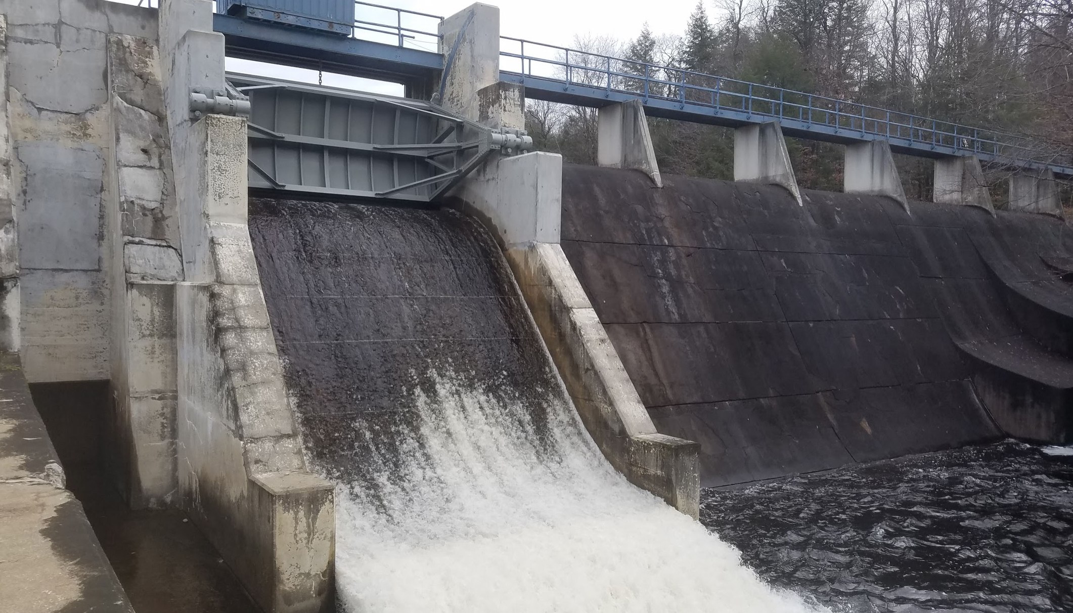
The lower, sluice gate is closed; the upper, tainter gate is open 3 or 4″; spillway is dry. The water level at Green Lake Bridge was 1540.94, 26″ below summer level.
November 17, 2020
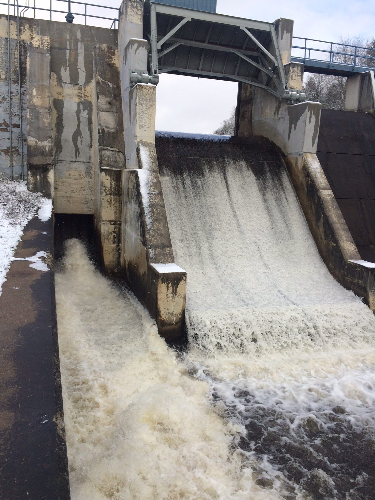
The upper, tainter gate is open, and the sluice gate is open about 5″. The sluice gate is open to lower the water level below the sill of the tainter gate to allow for replacement of the sill.
September 15, 2018
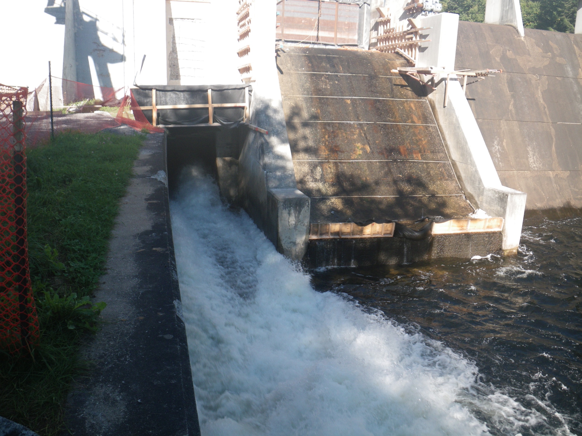
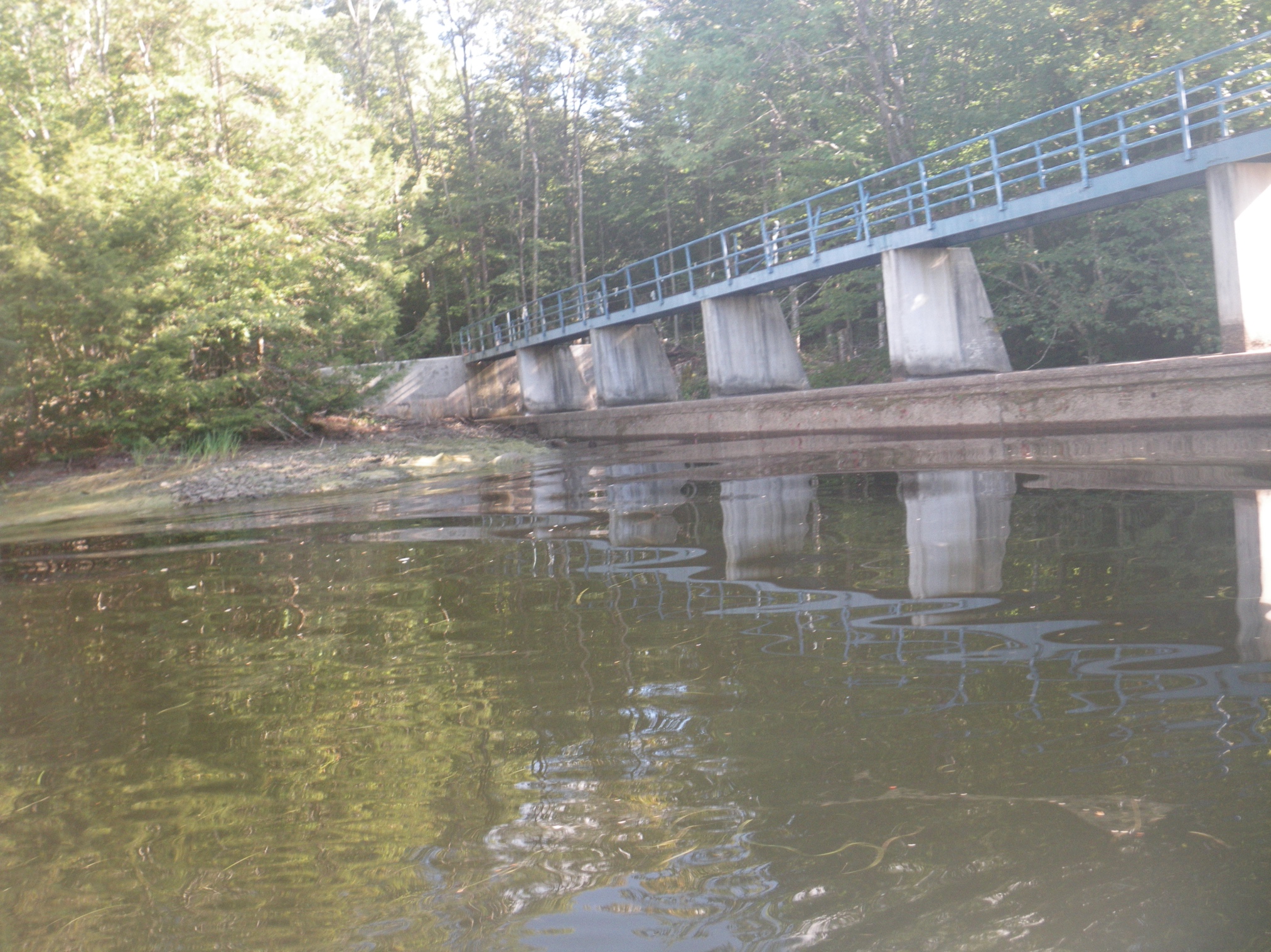
Dam while under repair in the fall of 2018. The lower, sluice was open 12.5″; the upper, tainter gate is closed under repair. No water running over the spillway. The water level at Green Lake Bridge was 1541.64, 18″ below summer level. At the dam the level was 39″ low.
September 23, 2018:
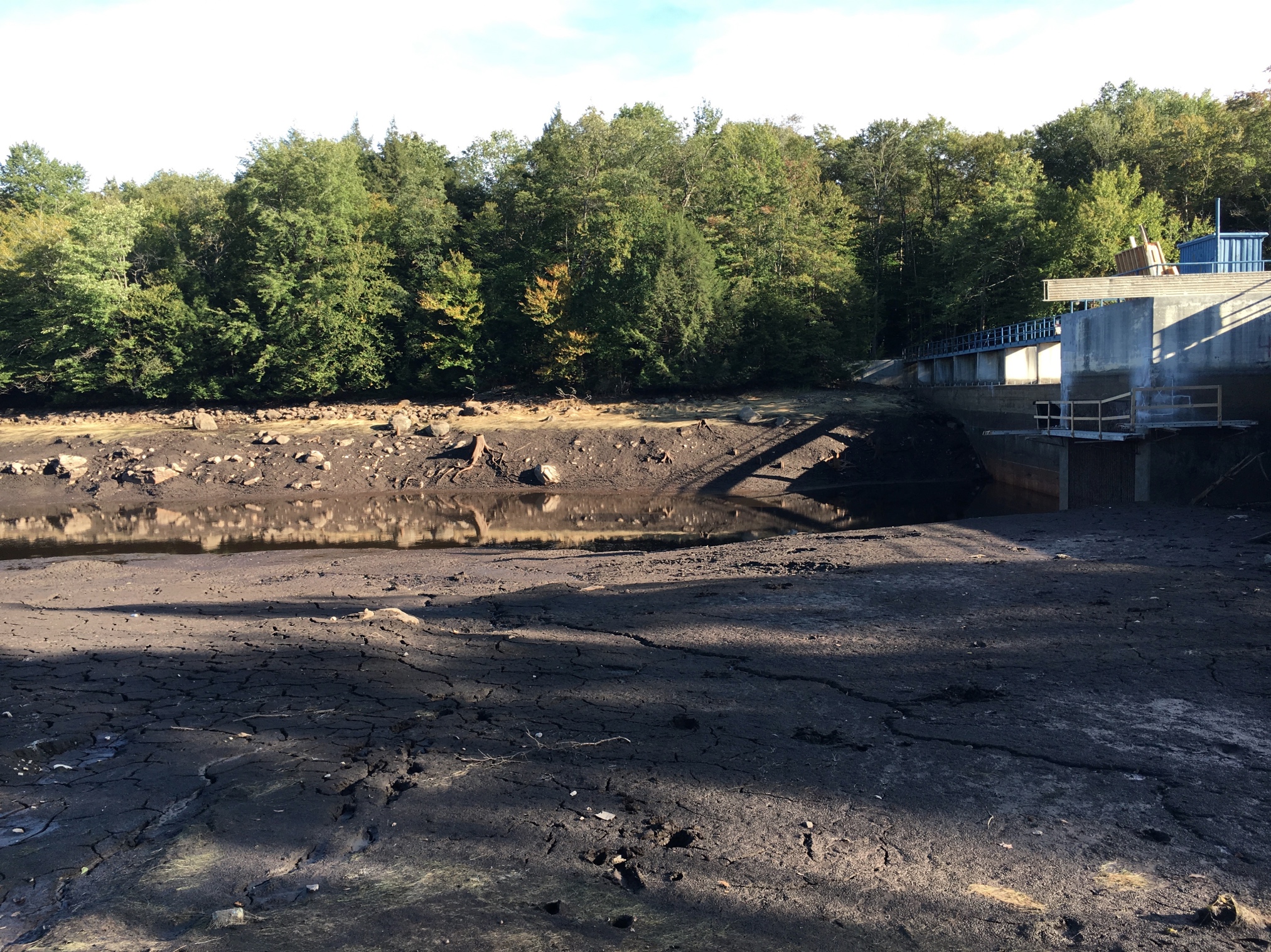
The dam during the repairs made in the fall of 2018. The water level at Green Lake Bridge was 1540.29, 34″ below summer level.